<< Our Photo Pages >> Pendinas Lochtyn - Hillfort in Wales in Ceredigion
Submitted by pab on Sunday, 16 September 2007 Page Views: 9403
Iron Age and Later PrehistorySite Name: Pendinas Lochtyn Alternative Name: Pen Dinas LochdynCountry: Wales County: Ceredigion Type: Hillfort
Nearest Town: Aberporth Nearest Village: Llangranog
Map Ref: SN31565486
Latitude: 52.166232N Longitude: 4.46425W
Condition:
| 5 | Perfect |
| 4 | Almost Perfect |
| 3 | Reasonable but with some damage |
| 2 | Ruined but still recognisable as an ancient site |
| 1 | Pretty much destroyed, possibly visible as crop marks |
| 0 | No data. |
| -1 | Completely destroyed |
| 5 | Superb |
| 4 | Good |
| 3 | Ordinary |
| 2 | Not Good |
| 1 | Awful |
| 0 | No data. |
| 5 | Can be driven to, probably with disabled access |
| 4 | Short walk on a footpath |
| 3 | Requiring a bit more of a walk |
| 2 | A long walk |
| 1 | In the middle of nowhere, a nightmare to find |
| 0 | No data. |
| 5 | co-ordinates taken by GPS or official recorded co-ordinates |
| 4 | co-ordinates scaled from a detailed map |
| 3 | co-ordinates scaled from a bad map |
| 2 | co-ordinates of the nearest village |
| 1 | co-ordinates of the nearest town |
| 0 | no data |
Internal Links:
External Links:
I have visited· I would like to visit
SolarMegalith would like to visit
SandyG visited on 13th Sep 2022 - their rating: Cond: 2 Amb: 5 Access: 3
PAB have visited here
")
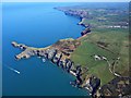
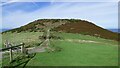
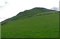
Pendinas means 'Fortified headland', a name found elsewhere in Wales, and also in Cornwall (eg St Ives). This is a wonderful example, with the enclosure itself being a very large 160m by 100m.
In fact, the hilltop enclosure is so large that modern buildings on its summit (whoever allowed that!) are fortunately not really visible except in the aerial shots linked to below.
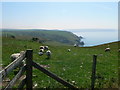
The RCAHMW entry records that several structures have been identified, including Roman with radio-carbon range from 85-420AD. It commands magnifiecent views, including those right round Cardigan Bay to Snowdonia and the Lleyn Peninsular in North Wales.
Two of my pictures are taken from the Ynys Lochtyn islet which is cut off at high tide - and which is a truly wonderful place to watch the dolphins heading for Newquay - not a bad way to have spent the weekend really!
The alternative name is really just a variation of spelling, included to help those searching from names sometimes used on OS maps. For aerial pictures, certainly worth visiting the Coflen site.
You may be viewing yesterday's version of this page. To see the most up to date information please register for a free account.
")
")
")
Do not use the above information on other web sites or publications without permission of the contributor.
Nearby Images from Geograph Britain and Ireland:
©2013(licence)
©2022(licence)

©2019(licence)
©2008(licence)
©2019(licence)
The above images may not be of the site on this page, they are loaded from Geograph.
Please Submit an Image of this site or go out and take one for us!
Click here to see more info for this site
Nearby sites
Key: Red: member's photo, Blue: 3rd party photo, Yellow: other image, Green: no photo - please go there and take one, Grey: site destroyed
Download sites to:
KML (Google Earth)
GPX (GPS waypoints)
CSV (Garmin/Navman)
CSV (Excel)
To unlock full downloads you need to sign up as a Contributory Member. Otherwise downloads are limited to 50 sites.
Turn off the page maps and other distractions
Nearby sites listing. In the following links * = Image available
666m N 350° Ynys Lochtyn* Ancient Village or Settlement (SN31475552)
2.1km SSW 211° Garreg Standing Stones Standing Stones (SN304531)
2.8km SSW 208° Gaer Lwyd Hillfort (SN30145240)
3.4km ENE 63° Gaer Wen Hillfort (SN34635630)
4.3km ESE 116° Castell Crugiau Ancient Village or Settlement (SN35395285)
4.4km SW 215° Corbalengi Stone* Sculptured Stone (SN2890151375)
4.8km SSW 199° Castell Nadolig Hillfort (SN29855040)
5.1km E 81° Felin Llwyn-Dafydd Promontory Fort / Cliff Castle (SN36685553)
5.5km NE 52° Castell Bach (Pen y Graig)* Ancient Village or Settlement (SN36045809)
6.0km SSW 201° Caer Pwntan Hillfort (SN29164933)
7.1km SE 139° Caerau Promontory Fort / Cliff Castle (SN36054940)
7.2km ESE 103° Ffynnon Dewi (Plwmp)* Holy Well or Sacred Spring (SN3854452988)
7.7km SE 127° Crug-Bach Barrow Round Barrow(s) (SN37554995)
7.8km SSE 155° Pensarngerrig* Standing Stones (SN346477)
7.9km ESE 123° Crug Du* Ring Cairn (SN38075039)
7.9km ESE 113° Crug Las Round Cairn (SN38805154)
9.0km ESE 111° Blaengowonfawr Round Barrow(s) (SN39905142)
9.6km ESE 104° Mynachlog-Uchaf Misc. Earthwork (SN40795215)
9.6km E 100° Crug Cou Round Barrow(s) (SN40975284)
9.8km E 98° Llwyn Crwn Barrow Round Barrow(s) (SN41275311)
10.3km SSW 197° Pant-Llech-Clawdd Burnt Mound Artificial Mound (SN28264505)
11.1km ENE 73° Cross of Gurhirt (Llanarth)* Early Christian Sculptured Stone (SN42295775)
11.8km SW 235° Llech Yr Ast Standing Stone (Menhir) (SN216485)
12.0km E 92° Banc Rhosgoch Fach* Stone Row / Alignment (SN43625409)
12.6km WSW 255° Foel y Mwnt* Promontory Fort / Cliff Castle (SN193520)
View more nearby sites and additional images


 We would like to know more about this location. Please feel free to add a brief description and any relevant information in your own language.
 Wir möchten mehr über diese Stätte erfahren. Bitte zögern Sie nicht, eine kurze Beschreibung und relevante Informationen in Deutsch hinzuzufügen.
 Nous aimerions en savoir encore un peu sur les lieux. S'il vous plaît n'hesitez pas à ajouter une courte description et tous les renseignements pertinents dans votre propre langue.
 Quisieramos informarnos un poco más de las lugares. No dude en añadir una breve descripción y otros datos relevantes en su propio idioma.