<< Our Photo Pages >> Cairn Buy - Cairn in Scotland in Dumfries and Galloway
Submitted by markj99 on Saturday, 03 October 2020 Page Views: 513
Neolithic and Bronze AgeSite Name: Cairn Buy Alternative Name: Cairn Buy, GarheughCountry: Scotland County: Dumfries and Galloway Type: Cairn
Map Ref: NX26835094
Latitude: 54.823288N Longitude: 4.697059W
Condition:
| 5 | Perfect |
| 4 | Almost Perfect |
| 3 | Reasonable but with some damage |
| 2 | Ruined but still recognisable as an ancient site |
| 1 | Pretty much destroyed, possibly visible as crop marks |
| 0 | No data. |
| -1 | Completely destroyed |
| 5 | Superb |
| 4 | Good |
| 3 | Ordinary |
| 2 | Not Good |
| 1 | Awful |
| 0 | No data. |
| 5 | Can be driven to, probably with disabled access |
| 4 | Short walk on a footpath |
| 3 | Requiring a bit more of a walk |
| 2 | A long walk |
| 1 | In the middle of nowhere, a nightmare to find |
| 0 | No data. |
| 5 | co-ordinates taken by GPS or official recorded co-ordinates |
| 4 | co-ordinates scaled from a detailed map |
| 3 | co-ordinates scaled from a bad map |
| 2 | co-ordinates of the nearest village |
| 1 | co-ordinates of the nearest town |
| 0 | no data |
Internal Links:
External Links:
I have visited· I would like to visit
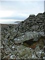
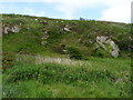
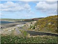
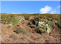
markj99 visited on 26th Sep 2020 - their rating: Cond: 3 Amb: 5 Access: 3 Despite its proximity to the coast Cairn Buy has a sense of isolation, on a patch of moorland with a sea view.
")
There is a thick moss carpet on the cairn lending it a patina of antiquity. Cairn Buy is listed under Canmore ID 62202.
Directions: At the top of the A75 Glenluce Bypass take the A747 Port William road. After 3.5 miles pass through Auchenmalg continuing along the coast to the Rocks of Garheugh, a series of sharp corners uphill. Park in the lay-by on the L 100 yards around the first corner. Walk back W for c. 300 yards to reach a gateway into a narrow field. Head E over stepping stones in a stream near the gate and keep E up a rough slope. After a few minutes the ground flattens into extensive moorland and Green House Bridge cairn should be visible ahead. Around 20 yards W of Green House Bridge Cairn there is a fork in the path at a boulder. Take the fainter L track heading W to Cairn Buy on the horizon.
You may be viewing yesterday's version of this page. To see the most up to date information please register for a free account.
")
")
")
Do not use the above information on other web sites or publications without permission of the contributor.
Nearby Images from Geograph Britain and Ireland:
©2007(licence)

©2009(licence)
©2012(licence)
©2010(licence)
©2018(licence)
The above images may not be of the site on this page, they are loaded from Geograph.
Please Submit an Image of this site or go out and take one for us!
Click here to see more info for this site
Nearby sites
Key: Red: member's photo, Blue: 3rd party photo, Yellow: other image, Green: no photo - please go there and take one, Grey: site destroyed
Download sites to:
KML (Google Earth)
GPX (GPS waypoints)
CSV (Garmin/Navman)
CSV (Excel)
To unlock full downloads you need to sign up as a Contributory Member. Otherwise downloads are limited to 50 sites.
Turn off the page maps and other distractions
Nearby sites listing. In the following links * = Image available
366m WNW 285° Green House Bridge Cairn* Cairn (NX26485105)
858m NW 325° Craignarget Hill* Cairn (NX26365166)
2.0km NW 317° High Gillespie* Passage Grave (NX25525245)
2.3km SSE 152° Chapel Finian Well* Holy Well or Sacred Spring (NX27834892)
2.7km SE 132° Corwall S* Cairn (NX28774905)
2.7km ESE 103° High Moor Hut Circle* Misc. Earthwork (NX29485024)
2.7km ESE 119° Corwall E* Cairn (NX29204953)
2.8km E 99° Brae Moor Cairn* Cairn (NX29595041)
2.9km NW 305° Steeps Park Stone Circle (NX245527)
3.0km NW 306° Gillespie Stone Standing Stone (Menhir) (NX245528)
3.2km E 83° Lang Riggs (The May) Cairn (NX29995119)
3.2km E 90° Brae Farm SW* Cairn (NX30035079)
3.2km E 89° Brae Farm Central* Cairn (NX30065088)
3.3km NW 310° Culquhasen-SE* Cairn (NX24435315)
3.3km E 80° The May Cairn* Cairn (NX30095141)
3.3km NNW 328° Culroy Farm Cairn* Cairn (NX25165383)
3.4km E 87° Brae Farm NE* Cairn (NX30225098)
3.5km E 79° Court Cairn, The May* Cairn (NX30265144)
3.7km ESE 102° Mochrum Fell (Elrig)* Cairn (NX30435004)
3.7km NNW 333° Culroy White Cairn* Cairn (NX25285435)
3.9km WNW 286° Mull of Sinniness* Standing Stone (Menhir) (NX23095220)
3.9km NNW 329° Culroy Cairn 1* Cairn (NX24905438)
4.1km NW 326° Machermore Cairns* Cairn (NX247544)
4.1km NW 307° Culquhasen* Cairn (NX23655350)
4.1km NNE 25° Castle Loch* Cairn (NX28695460)
View more nearby sites and additional images
Hut Enclosure and Early Field System South of Mynydd Graigwen >>


 We would like to know more about this location. Please feel free to add a brief description and any relevant information in your own language.
 Wir möchten mehr über diese Stätte erfahren. Bitte zögern Sie nicht, eine kurze Beschreibung und relevante Informationen in Deutsch hinzuzufügen.
 Nous aimerions en savoir encore un peu sur les lieux. S'il vous plaît n'hesitez pas à ajouter une courte description et tous les renseignements pertinents dans votre propre langue.
 Quisieramos informarnos un poco más de las lugares. No dude en añadir una breve descripción y otros datos relevantes en su propio idioma.