

<< Our Photo Pages >> Red Post Barrows - Barrow Cemetery in England in Cornwall
Submitted by dooclay on Wednesday, 03 September 2025 Page Views: 377
Neolithic and Bronze AgeSite Name: Red Post BarrowsCountry: England
NOTE: This site is 0.9 km away from the location you searched for.
County: Cornwall Type: Barrow Cemetery
Nearest Town: Stratton Nearest Village: Pancrasweek
Map Ref: SS26330547
Latitude: 50.822658N Longitude: 4.467066W
Condition:
| 5 | Perfect |
| 4 | Almost Perfect |
| 3 | Reasonable but with some damage |
| 2 | Ruined but still recognisable as an ancient site |
| 1 | Pretty much destroyed, possibly visible as crop marks |
| 0 | No data. |
| -1 | Completely destroyed |
| 5 | Superb |
| 4 | Good |
| 3 | Ordinary |
| 2 | Not Good |
| 1 | Awful |
| 0 | No data. |
| 5 | Can be driven to, probably with disabled access |
| 4 | Short walk on a footpath |
| 3 | Requiring a bit more of a walk |
| 2 | A long walk |
| 1 | In the middle of nowhere, a nightmare to find |
| 0 | No data. |
| 5 | co-ordinates taken by GPS or official recorded co-ordinates |
| 4 | co-ordinates scaled from a detailed map |
| 3 | co-ordinates scaled from a bad map |
| 2 | co-ordinates of the nearest village |
| 1 | co-ordinates of the nearest town |
| 0 | no data |
Internal Links:
External Links:
")
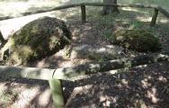
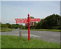
Three Barrows north of Red Post Crossroads, Source Cornwall HER:
HER 443 A grass covered bowl barrow 24m in diameter and 1.0m high, with no visible ditch.
HER 443.10 A grass covered bowl barrow 28m in diameter and 1.3m high, with no visible ditch.
HER 443.20 A bowl barrow approx 30m by 40m in diameter and 1.0m high.
You may be viewing yesterday's version of this page. To see the most up to date information please register for a free account.
")
")
")
Do not use the above information on other web sites or publications without permission of the contributor.
Nearby Images from Geograph Britain and Ireland:
©2014(licence)
©2017(licence)
©2017(licence)
©2019(licence)

©2025(licence)
The above images may not be of the site on this page, they are loaded from Geograph.
Please Submit an Image of this site or go out and take one for us!
Click here to see more info for this site
Nearby sites
Key: Red: member's photo, Blue: 3rd party photo, Yellow: other image, Green: no photo - please go there and take one, Grey: site destroyed
Download sites to:
KML (Google Earth)
GPX (GPS waypoints)
CSV (Garmin/Navman)
CSV (Excel)
To unlock full downloads you need to sign up as a Contributory Member. Otherwise downloads are limited to 50 sites.
Turn off the page maps and other distractions
Nearby sites listing. In the following links * = Image available
1.9km W 275° St Swithin's Well (Launcells)* Holy Well or Sacred Spring (SS244057)
3.9km WNW 292° Stamford Hill settlement* Ancient Village or Settlement (SS22750705)
4.4km WSW 244° Marhamchurch Medieval cross* Ancient Cross (SS22300369)
4.7km WNW 297° Earthquake Cist* Cist (SS22250773)
5.0km W 260° Neet Valley stone, Bude Standing Stone (Menhir) (SS21320474)
5.4km NNW 339° Brentspool Barrows* Round Barrow(s) (SS24561057)
5.7km WSW 245° Whalesborough Barrows* Round Barrow(s) (SS21020323)
5.8km S 187° Froxton Wood Castle* Hillfort (SX2543099705)
5.9km S 189° Hilton Wood Castle* Hillfort (SX25229969)
6.1km W 281° Summerleaze Barrows* Barrow Cemetery (SS2038106810)
6.2km ENE 69° Ugworthy Beacon Barrows* Round Barrow(s) (SS3217607440)
6.2km NNW 344° Ladywell (Kilkhampton) Holy Well or Sacred Spring (SS2485111487)
6.3km W 276° Compass Point Barrow* Round Barrow(s) (SS20040635)
6.6km WSW 254° Higher Longbeak Barrow* Round Barrow(s) (SS19950389)
6.6km WNW 292° Northcott Mouth Tumuli* Barrow Cemetery (SS203081)
6.8km WSW 249° Widemouth Bay tumulus* Round Barrow(s) (SS19870323)
7.0km S 178° St Anne's Well (Whitstone)* Holy Well or Sacred Spring (SX263985)
7.1km N 1° Taylors Cross Tumuli* Round Barrow(s) (SS2669012535)
7.4km S 189° Swannacott Round Ancient Village or Settlement (SX24989817)
7.7km SE 131° Affaland Moor Bowl Barrow* Round Barrow(s) (SS3196200184)
8.1km SW 227° St Neot's Well (Poundstock)* Holy Well or Sacred Spring (SS2018800184)
8.3km E 100° Holsworthy St Peter’s Well Holy Well or Sacred Spring (SS345038)
8.7km SSW 202° Ashbury hillfort* Hillfort (SX228975)
8.7km S 173° Dilland Barrow* Round Barrow(s) (SX27109679)
8.8km N 351° Wrasford Moor Barrow Cemetary* Barrow Cemetery (SS2529114170)
View more nearby sites and additional images


 We would like to know more about this location. Please feel free to add a brief description and any relevant information in your own language.
 Wir möchten mehr über diese Stätte erfahren. Bitte zögern Sie nicht, eine kurze Beschreibung und relevante Informationen in Deutsch hinzuzufügen.
 Nous aimerions en savoir encore un peu sur les lieux. S'il vous plaît n'hesitez pas à ajouter une courte description et tous les renseignements pertinents dans votre propre langue.
 Quisieramos informarnos un poco más de las lugares. No dude en añadir una breve descripción y otros datos relevantes en su propio idioma.