<< Image Pages >> Maxwelstone Camp - Hillfort in Scotland in South Ayrshire
Submitted by durhamnature on Tuesday, 30 October 2012 Page Views: 2272
Iron Age and Later PrehistorySite Name: Maxwelstone CampCountry: Scotland
NOTE: This site is 1.7 km away from the location you searched for.
County: South Ayrshire Type: Hillfort
Map Ref: NX25959895
Latitude: 55.253917N Longitude: 4.740017W
Condition:
| 5 | Perfect |
| 4 | Almost Perfect |
| 3 | Reasonable but with some damage |
| 2 | Ruined but still recognisable as an ancient site |
| 1 | Pretty much destroyed, possibly visible as crop marks |
| 0 | No data. |
| -1 | Completely destroyed |
| 5 | Superb |
| 4 | Good |
| 3 | Ordinary |
| 2 | Not Good |
| 1 | Awful |
| 0 | No data. |
| 5 | Can be driven to, probably with disabled access |
| 4 | Short walk on a footpath |
| 3 | Requiring a bit more of a walk |
| 2 | A long walk |
| 1 | In the middle of nowhere, a nightmare to find |
| 0 | No data. |
| 5 | co-ordinates taken by GPS or official recorded co-ordinates |
| 4 | co-ordinates scaled from a detailed map |
| 3 | co-ordinates scaled from a bad map |
| 2 | co-ordinates of the nearest village |
| 1 | co-ordinates of the nearest town |
| 0 | no data |
Be the first person to rate this site - see the 'Contribute!' box in the right hand menu.
Internal Links:
External Links:
")
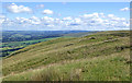
An oval fort, possibly unfinished, consisting of two earthen ramparts, which are presumably contemporary although not concentric, with external quarry ditches. The interior measures 87 by 62m and there are entrances on the west and ENE respectively.
The defences can be traced round the summit of the hill except on the steep NW side, where the abrupt and well defined terminals of the ditches suggest that they have not continued round this side.
The ramparts are still well defined on the east where they measure 7.3m in maximum width, 1m externally and 0.3m internally in maximum height. Elsewhere they exist only as crest lines. Both ramparts and ditches have an unfinished look, the ditch being perfunctory in some places as though it were simply a marking-out trench. There is a staggered causewayed entrance on the east with the break in the inner rampart 7m wide and the outer 5m.
Text updated and adapted from Canmore.
Canmore ID 62566
You may be viewing yesterday's version of this page. To see the most up to date information please register for a free account.
Do not use the above information on other web sites or publications without permission of the contributor.
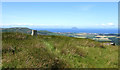
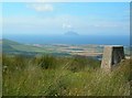
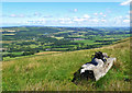
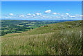
Nearby Images from Geograph Britain and Ireland:
©2020(licence)
©2007(licence)
©2020(licence)
©2020(licence)
©2020(licence)
The above images may not be of the site on this page, they are loaded from Geograph.
Please Submit an Image of this site or go out and take one for us!
Click here to see more info for this site
Nearby sites
Key: Red: member's photo, Blue: 3rd party photo, Yellow: other image, Green: no photo - please go there and take one, Grey: site destroyed
Download sites to:
KML (Google Earth)
GPX (GPS waypoints)
CSV (Garmin/Navman)
CSV (Excel)
To unlock full downloads you need to sign up as a Contributory Member. Otherwise downloads are limited to 50 sites.
Turn off the page maps and other distractions
Nearby sites listing. In the following links * = Image available
3.3km N 11° Cairn Hill (Dalquharran)* Cairn (NS26690219)
5.2km N 357° East Threave* Cairn (NS25870411)
5.2km NNE 27° Captain's Bridge (Drummochreen) SE* Stone Fort or Dun (NS28530351)
5.3km NNE 27° Captain's Bridge (Drummochreen) W* Hillfort (NS28510356)
8.3km SW 223° Dinvin Earthworks* Misc. Earthwork (NX2002993173)
8.4km ENE 77° Knockinculloch* Ancient Village or Settlement (NS34200050)
9.0km ESE 118° Bencallen Hill* Chambered Cairn (NX33779440)
9.3km NNE 23° Kildoon Hillfort* Hillfort (NS29860738)
9.3km NNW 332° Shanter Knowe* Artificial Mound (NS21890738)
10.2km NNW 327° Bains Hill* Standing Stone (Menhir) (NS20750773)
11.8km SSW 199° Glake Stone* Standing Stone (Menhir) (NX21678790)
12.2km N 357° Balchriston* Stone Fort or Dun (NS2572911176)
12.5km NNE 21° Lyonston Stone* Standing Stone (Menhir) (NS30991039)
13.0km N 6° Howmoor* Stone Fort or Dun (NS2770711809)
14.4km S 176° Balmalloch Chambered Cairn* Chambered Cairn (NX2638784532)
14.4km E 92° Cairnwhapple Stone* Natural Stone / Erratic / Other Natural Feature (NX40399796)
14.6km S 176° Balmalloch Cairnfield* Barrow Cemetery (NX26488439)
15.2km SE 139° Cairnfore* Cairn (NX35548707)
16.0km S 180° Laggan Cairn (Barrhill)* Cairn (NX25358297)
17.0km SSE 150° Sheuchan's Cairn* Chambered Cairn (NX33798387)
17.0km SSW 192° Barrhill White Cairn* Cairn (NX21898244)
17.3km ESE 108° Moss Knowes* Natural Stone / Erratic / Other Natural Feature (NX42239281)
17.9km SE 137° Kirriemore* Chambered Cairn (NX37738544)
18.6km SSW 204° Arecleoch Standing Stone* Standing Stone (Menhir) (NX178822)
18.6km NNE 33° Barbieston Farm cist* Cist (NS36751417)
View more nearby sites and additional images


 We would like to know more about this location. Please feel free to add a brief description and any relevant information in your own language.
 Wir möchten mehr über diese Stätte erfahren. Bitte zögern Sie nicht, eine kurze Beschreibung und relevante Informationen in Deutsch hinzuzufügen.
 Nous aimerions en savoir encore un peu sur les lieux. S'il vous plaît n'hesitez pas à ajouter une courte description et tous les renseignements pertinents dans votre propre langue.
 Quisieramos informarnos un poco más de las lugares. No dude en añadir una breve descripción y otros datos relevantes en su propio idioma.