<< Our Photo Pages >> Knock Hill Fort - Hillfort in Scotland in Dumfries and Galloway
Submitted by cosmic on Saturday, 09 October 2004 Page Views: 8159
Iron Age and Later PrehistorySite Name: Knock Hill FortCountry: Scotland County: Dumfries and Galloway Type: Hillfort
Nearest Town: Stranraer
Map Ref: NX25505577
Latitude: 54.866182N Longitude: 4.720654W
Condition:
| 5 | Perfect |
| 4 | Almost Perfect |
| 3 | Reasonable but with some damage |
| 2 | Ruined but still recognisable as an ancient site |
| 1 | Pretty much destroyed, possibly visible as crop marks |
| 0 | No data. |
| -1 | Completely destroyed |
| 5 | Superb |
| 4 | Good |
| 3 | Ordinary |
| 2 | Not Good |
| 1 | Awful |
| 0 | No data. |
| 5 | Can be driven to, probably with disabled access |
| 4 | Short walk on a footpath |
| 3 | Requiring a bit more of a walk |
| 2 | A long walk |
| 1 | In the middle of nowhere, a nightmare to find |
| 0 | No data. |
| 5 | co-ordinates taken by GPS or official recorded co-ordinates |
| 4 | co-ordinates scaled from a detailed map |
| 3 | co-ordinates scaled from a bad map |
| 2 | co-ordinates of the nearest village |
| 1 | co-ordinates of the nearest town |
| 0 | no data |
Internal Links:
External Links:
I have visited· I would like to visit
SumDoood would like to visit
")
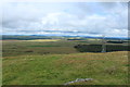
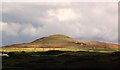
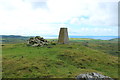
This hill dominates the NW corner of the Machars. There is very little evidence left of the actual hill fort.
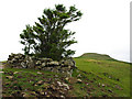
For futher information see Canmore ID 62146 which describes this as "oval stone walled fort measuring internally 160.0m NE-SW by 85.0m transversely. The walling remains for the most part as a 2.5m spread of stones reduced almost to ground level but can be seen for a short stretch on both the E and W sides where it is spread to a width of about 10.0m. On the NW the wall has been almost destroyed. There is an apparent entrance 5.0m wide in the SW and another gap in the ENE appearing more as a later mutilation than an original entrance. A short length of a ruined outer wall 2.5m wide is visible on the W side about 20.0m distant from the main enclosure. The rock outcrop and walling running across the enclosed area is as described but is of uncertain age and purpose. There is no trace of hut circles either within or near this fort."
You may be viewing yesterday's version of this page. To see the most up to date information please register for a free account.
")
Do not use the above information on other web sites or publications without permission of the contributor.
Nearby Images from Geograph Britain and Ireland:
©2015(licence)
©2007(licence)
©2015(licence)
©2008(licence)
©2015(licence)
The above images may not be of the site on this page, they are loaded from Geograph.
Please Submit an Image of this site or go out and take one for us!
Click here to see more info for this site
Nearby sites
Key: Red: member's photo, Blue: 3rd party photo, Yellow: other image, Green: no photo - please go there and take one, Grey: site destroyed
Download sites to:
KML (Google Earth)
GPX (GPS waypoints)
CSV (Garmin/Navman)
CSV (Excel)
To unlock full downloads you need to sign up as a Contributory Member. Otherwise downloads are limited to 50 sites.
Turn off the page maps and other distractions
Nearby sites listing. In the following links * = Image available
1.4km S 187° Culroy White Cairn* Cairn (NX25285435)
1.5km SSW 201° Culroy Cairn 1* Cairn (NX24905438)
1.6km SSW 208° Machermore Cairns* Cairn (NX247544)
2.0km S 188° Culroy Farm Cairn* Cairn (NX25165383)
2.1km WSW 244° Whitefield Loch Crannog* Crannog (NX23555493)
2.2km WSW 257° Barnsallie Fell* Cairn (NX23355535)
2.9km SW 217° Culquhasen* Cairn (NX23655350)
3.1km SSW 196° Gillespie Stone Standing Stone (Menhir) (NX245528)
3.2km SSW 196° Steeps Park Stone Circle (NX245527)
3.3km S 177° High Gillespie* Passage Grave (NX25525245)
3.4km ESE 108° Castle Loch* Cairn (NX28695460)
3.4km N 5° Barhapple Crannogs* Crannog (NX25955915)
4.2km SSE 166° Craignarget Hill* Cairn (NX26365166)
4.3km SSW 212° Mull of Sinniness* Standing Stone (Menhir) (NX23095220)
4.4km WNW 302° Coffin Stone (Glenluce)* Natural Stone / Erratic / Other Natural Feature (NX2183158227)
4.5km WSW 252° Chapel Well (St Fillan's) Holy Well or Sacred Spring (NX21195457)
4.8km SSE 166° Green House Bridge Cairn* Cairn (NX26485105)
5.0km SSE 162° Cairn Buy* Cairn (NX26835094)
5.0km WNW 290° Lady Well (Glenluce) Holy Well or Sacred Spring (NX20845768)
5.2km WSW 240° Stairhaven Broch* Broch or Nuraghe (NX2090353351)
5.3km SW 225° Laigh Sinniness* Promontory Fort / Cliff Castle (NX21575219)
6.0km WNW 285° St John's Well (Glenluce) Holy Well or Sacred Spring (NX19705752)
6.2km NW 320° Ballach-a-Heathry* Cairn (NX21656065)
6.3km SE 131° The May Cairn* Cairn (NX30095141)
6.4km SE 133° Lang Riggs (The May) Cairn (NX29995119)
View more nearby sites and additional images


 We would like to know more about this location. Please feel free to add a brief description and any relevant information in your own language.
 Wir möchten mehr über diese Stätte erfahren. Bitte zögern Sie nicht, eine kurze Beschreibung und relevante Informationen in Deutsch hinzuzufügen.
 Nous aimerions en savoir encore un peu sur les lieux. S'il vous plaît n'hesitez pas à ajouter une courte description et tous les renseignements pertinents dans votre propre langue.
 Quisieramos informarnos un poco más de las lugares. No dude en añadir una breve descripción y otros datos relevantes en su propio idioma.