

<< Our Photo Pages >> Barnsallie Fell - Cairn in Scotland in Dumfries and Galloway
Submitted by markj99 on Sunday, 14 May 2023 Page Views: 333
Neolithic and Bronze AgeSite Name: Barnsallie FellCountry: Scotland County: Dumfries and Galloway Type: Cairn
Nearest Town: Stranraer Nearest Village: Glenluce
Map Ref: NX23355535
Latitude: 54.861657N Longitude: 4.753856W
Condition:
| 5 | Perfect |
| 4 | Almost Perfect |
| 3 | Reasonable but with some damage |
| 2 | Ruined but still recognisable as an ancient site |
| 1 | Pretty much destroyed, possibly visible as crop marks |
| 0 | No data. |
| -1 | Completely destroyed |
| 5 | Superb |
| 4 | Good |
| 3 | Ordinary |
| 2 | Not Good |
| 1 | Awful |
| 0 | No data. |
| 5 | Can be driven to, probably with disabled access |
| 4 | Short walk on a footpath |
| 3 | Requiring a bit more of a walk |
| 2 | A long walk |
| 1 | In the middle of nowhere, a nightmare to find |
| 0 | No data. |
| 5 | co-ordinates taken by GPS or official recorded co-ordinates |
| 4 | co-ordinates scaled from a detailed map |
| 3 | co-ordinates scaled from a bad map |
| 2 | co-ordinates of the nearest village |
| 1 | co-ordinates of the nearest town |
| 0 | no data |
Internal Links:
External Links:
I have visited· I would like to visit
markj99 visited on 9th May 2023 - their rating: Cond: 2 Amb: 4 Access: 3 Take the A747 Portwilliam turn off the A75 at Glenluce. Follow the road for c. 1.8 miles to reach a left turn signed for Whithorn Way. Stay on this single track road for c. 1 mile to reach a left turn signed for Craigenveoch via a forest track. There is a lay-by on the edge of the loch after c. 100 yards if you want to park up. Continue on foot or by car for c. 0.2 miles to reach a parking place at Knock of Luce Wood. Walk c. 200 yards W along a grass track leading to a dead-end. Take the loch side path for on the left for c. 200 yards to reach NSF Scotland Woodland Garden. Take a path NW starting at the NSF Scotland info board. Head W towards an obvious gap in the stone wall. Wellies are required from this point. Cross a stream then head N parallel to the stone wall through boggy shrubby ground for c. 100 yards to reach Barnsallie Fell Cairn, shrouded in small trees.
")
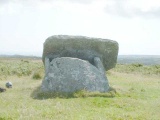
Barnsallie Fell Cairn is a small grassy mound, located c. 130 yards N of Whitefield Loch, in the SE corner of Barnsallie Fell in Dumfries and Galloway. It is in a clearing in scrubland on the W edge of Craigenveoch Wood. A tree growing out of the central hollow of the cairn has all but obscured the ancient remains. Viewed from the S, a tree surrounded by a circle of brushwood can be seen. According to Canmore ID 62154 the mound measured "5.0m in diameter and 0.8m high" in 1976. This was difficult to check accurately due to impenetrable vegetation but it seemed to be a good visual estimate.
You may be viewing yesterday's version of this page. To see the most up to date information please register for a free account.
")
")
")
")
")
Do not use the above information on other web sites or publications without permission of the contributor.
Click here to see more info for this site
Nearby sites
Key: Red: member's photo, Blue: 3rd party photo, Yellow: other image, Green: no photo - please go there and take one, Grey: site destroyed
Download sites to:
KML (Google Earth)
GPX (GPS waypoints)
CSV (Garmin/Navman)
CSV (Excel)
To unlock full downloads you need to sign up as a Contributory Member. Otherwise downloads are limited to 50 sites.
Turn off the page maps and other distractions
Nearby sites listing. In the following links * = Image available
464m SSE 152° Whitefield Loch Crannog* Crannog (NX23555493)
1.6km ESE 123° Machermore Cairns* Cairn (NX247544)
1.8km ESE 120° Culroy Cairn 1* Cairn (NX24905438)
1.9km SSE 169° Culquhasen* Cairn (NX23655350)
2.2km ESE 115° Culroy White Cairn* Cairn (NX25285435)
2.2km ENE 77° Knock Hill Fort* Hillfort (NX25505577)
2.3km WSW 248° Chapel Well (St Fillan's) Holy Well or Sacred Spring (NX21195457)
2.4km SE 128° Culroy Farm Cairn* Cairn (NX25165383)
2.8km SSE 154° Gillespie Stone Standing Stone (Menhir) (NX245528)
2.9km SSE 154° Steeps Park Stone Circle (NX245527)
3.2km SW 228° Stairhaven Broch* Broch or Nuraghe (NX2090353351)
3.2km S 182° Mull of Sinniness* Standing Stone (Menhir) (NX23095220)
3.2km NNW 330° Coffin Stone (Glenluce)* Natural Stone / Erratic / Other Natural Feature (NX2183158227)
3.4km NW 311° Lady Well (Glenluce) Holy Well or Sacred Spring (NX20845768)
3.6km SE 141° High Gillespie* Passage Grave (NX25525245)
3.6km SSW 207° Laigh Sinniness* Promontory Fort / Cliff Castle (NX21575219)
4.2km WNW 299° St John's Well (Glenluce) Holy Well or Sacred Spring (NX19705752)
4.6km NNE 32° Barhapple Crannogs* Crannog (NX25955915)
4.8km SE 139° Craignarget Hill* Cairn (NX26365166)
5.3km SE 142° Green House Bridge Cairn* Cairn (NX26485105)
5.4km E 96° Castle Loch* Cairn (NX28695460)
5.6km NNW 340° Ballach-a-Heathry* Cairn (NX21656065)
5.6km SE 140° Cairn Buy* Cairn (NX26835094)
5.8km WNW 303° St Katherine's Well (Glenluce)* Holy Well or Sacred Spring (NX18605873)
5.8km NNW 337° Benlaight South* Cairn (NX21246078)
View more nearby sites and additional images


 We would like to know more about this location. Please feel free to add a brief description and any relevant information in your own language.
 Wir möchten mehr über diese Stätte erfahren. Bitte zögern Sie nicht, eine kurze Beschreibung und relevante Informationen in Deutsch hinzuzufügen.
 Nous aimerions en savoir encore un peu sur les lieux. S'il vous plaît n'hesitez pas à ajouter une courte description et tous les renseignements pertinents dans votre propre langue.
 Quisieramos informarnos un poco más de las lugares. No dude en añadir una breve descripción y otros datos relevantes en su propio idioma.