


<< Our Photo Pages >> Colquite Menhir - Standing Stone (Menhir) in England in Cornwall
Submitted by TheCaptain on Saturday, 04 December 2010 Page Views: 4949
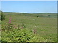
Neolithic and Bronze AgeSite Name: Colquite MenhirCountry: England County: Cornwall Type: Standing Stone (Menhir)
Nearest Town: Launceston Nearest Village: Altarnun
Map Ref: SX22657675
Latitude: 50.563520N Longitude: 4.505467W
Condition:
| 5 | Perfect |
| 4 | Almost Perfect |
| 3 | Reasonable but with some damage |
| 2 | Ruined but still recognisable as an ancient site |
| 1 | Pretty much destroyed, possibly visible as crop marks |
| 0 | No data. |
| -1 | Completely destroyed |
| 5 | Superb |
| 4 | Good |
| 3 | Ordinary |
| 2 | Not Good |
| 1 | Awful |
| 0 | No data. |
| 5 | Can be driven to, probably with disabled access |
| 4 | Short walk on a footpath |
| 3 | Requiring a bit more of a walk |
| 2 | A long walk |
| 1 | In the middle of nowhere, a nightmare to find |
| 0 | No data. |
| 5 | co-ordinates taken by GPS or official recorded co-ordinates |
| 4 | co-ordinates scaled from a detailed map |
| 3 | co-ordinates scaled from a bad map |
| 2 | co-ordinates of the nearest village |
| 1 | co-ordinates of the nearest town |
| 0 | no data |
Internal Links:
External Links:
I have visited· I would like to visit
TheCaptain has visited here
")
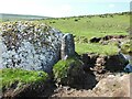
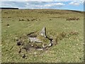
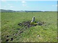
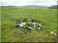
The stone is nearly 6 feet tall in a little enclosure type area where the walls go around it, which would seem unusual for many reasons. It is a slender stone only one and a half feet wide at the bottom. There are no markings which I would expect of a boundary stone, but there is one hole two thirds the way up, which suggests perhaps once it was a gatepost – but why would the walls avoid it?
You may be viewing yesterday's version of this page. To see the most up to date information please register for a free account.
")
")
")
")
Do not use the above information on other web sites or publications without permission of the contributor.
Nearby Images from Geograph Britain and Ireland:
©2021(licence)
©2021(licence)
©2021(licence)
©2021(licence)
©2005(licence)
The above images may not be of the site on this page, they are loaded from Geograph.
Please Submit an Image of this site or go out and take one for us!
Click here to see more info for this site
Nearby sites
Key: Red: member's photo, Blue: 3rd party photo, Yellow: other image, Green: no photo - please go there and take one, Grey: site destroyed
Download sites to:
KML (Google Earth)
GPX (GPS waypoints)
CSV (Garmin/Navman)
CSV (Excel)
To unlock full downloads you need to sign up as a Contributory Member. Otherwise downloads are limited to 50 sites.
Turn off the page maps and other distractions
Nearby sites listing. In the following links * = Image available
474m NNW 340° Greymare Rock* Natural Stone / Erratic / Other Natural Feature (SX225772)
838m NNW 327° East Moor menhir* Standing Stone (Menhir) (SX22227747)
846m NNW 344° East Moor stone C* Standing Stone (Menhir) (SX22447757)
901m NNW 339° East Moor stone B* Standing Stone (Menhir) (SX22357760)
902m NNW 343° East Moor cairn* Round Cairn (SX22417762)
924m NNW 336° East Moor Stone D* Standing Stone (Menhir) (SX2230077606)
946m NE 43° Redmoor Marsh* Misc. Earthwork (SX23327742)
983m NNW 341° East Moor ring cairn* Ring Cairn (SX22367769)
1.0km NNW 340° East Moor Row blocking stone* Standing Stone (Menhir) (SX22327773)
1.1km NNW 340° East Moor Enclosure Ancient Village or Settlement (SX223778)
1.3km N 350° East Moor stone row* Stone Row / Alignment (SX22477803)
1.7km NNE 33° Nine Stones (Altarnun)* Stone Circle (SX23617814)
1.8km SE 126° King Arthur's Bed* Natural Stone / Erratic / Other Natural Feature (SX24057568)
1.9km N 9° Fox Tor stone setting* Standing Stones (SX23027863)
2.0km NE 55° The Ridge Cairn* Cairn (SX24337785)
2.1km NE 44° Clitters Cairn* Cairn (SX24157821)
2.2km ENE 67° Bowda Stone Circle* Stone Circle (SX24757757)
2.4km N 3° Tregune Menhir* Standing Stone (Menhir) (SX2286379095)
2.4km SW 226° Goodaver* Stone Circle (SX20877515)
2.4km SW 224° Goodaver Round Cairn* Cairn (SX20927509)
2.4km W 280° Carneglos Barrow* Ring Cairn (SX20287725)
2.4km ESE 121° Trewortha Cairns* Cairn (SX24697543)
2.6km WSW 241° Smiths Moor Cairn Cairn (SX20367560)
2.6km WSW 242° Smiths Moor Field System and Cairns Cairn (SX20357562)
2.6km SE 131° Trewortha Kerb cairn and cist* Chambered Cairn (SX24527499)
View more nearby sites and additional images


 We would like to know more about this location. Please feel free to add a brief description and any relevant information in your own language.
 Wir möchten mehr über diese Stätte erfahren. Bitte zögern Sie nicht, eine kurze Beschreibung und relevante Informationen in Deutsch hinzuzufügen.
 Nous aimerions en savoir encore un peu sur les lieux. S'il vous plaît n'hesitez pas à ajouter une courte description et tous les renseignements pertinents dans votre propre langue.
 Quisieramos informarnos un poco más de las lugares. No dude en añadir una breve descripción y otros datos relevantes en su propio idioma.