<< Our Photo Pages >> Benlaight North - Cairn in Scotland in Dumfries and Galloway
Submitted by markj99 on Monday, 21 March 2022 Page Views: 320
Neolithic and Bronze AgeSite Name: Benlaight NorthCountry: Scotland
NOTE: This site is 1.6 km away from the location you searched for.
County: Dumfries and Galloway Type: Cairn
Nearest Town: Stranraer Nearest Village: Glenluce
Map Ref: NX21196112
Latitude: 54.912680N Longitude: 4.791047W
Condition:
| 5 | Perfect |
| 4 | Almost Perfect |
| 3 | Reasonable but with some damage |
| 2 | Ruined but still recognisable as an ancient site |
| 1 | Pretty much destroyed, possibly visible as crop marks |
| 0 | No data. |
| -1 | Completely destroyed |
| 5 | Superb |
| 4 | Good |
| 3 | Ordinary |
| 2 | Not Good |
| 1 | Awful |
| 0 | No data. |
| 5 | Can be driven to, probably with disabled access |
| 4 | Short walk on a footpath |
| 3 | Requiring a bit more of a walk |
| 2 | A long walk |
| 1 | In the middle of nowhere, a nightmare to find |
| 0 | No data. |
| 5 | co-ordinates taken by GPS or official recorded co-ordinates |
| 4 | co-ordinates scaled from a detailed map |
| 3 | co-ordinates scaled from a bad map |
| 2 | co-ordinates of the nearest village |
| 1 | co-ordinates of the nearest town |
| 0 | no data |
Internal Links:
External Links:
I have visited· I would like to visit
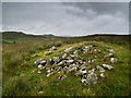
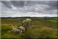
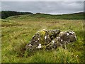
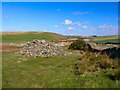
markj99 visited on 20th Mar 2022 - their rating: Cond: 2 Amb: 4 Access: 3 Benlaight North Cairn is a probable small cairn in moorland c. 2 miles N of Glenluce. It is almost entirely robbed out. It is easily visited along with Benlaight South Cairn and Ballach-a-Heathry Cairn. Three for the price of one is always good value!
")
Benlaight North Cairn is an oval green spot in brown moorland at NX 21190 61119. It measures c. 20 feet E-W and 15 feet N-S up to a height of c. 1 foot in the centre. Small earth-set stones protrude from the centre. It is probably a robbed out small cairn.
There is a cairn c. 25 yards W at NX 21170 61117 on a W facing slope. The shape is irregular and there are scattered small stones in the centre indicating that it could be a clearance cairn.
Canmore ID 62411 has an account of some low cairns and hut circles in this area.
You may be viewing yesterday's version of this page. To see the most up to date information please register for a free account.
")
")
")
")
Do not use the above information on other web sites or publications without permission of the contributor.
Nearby Images from Geograph Britain and Ireland:
©2013(licence)
©2013(licence)
©2013(licence)
©2022(licence)
©2011(licence)
The above images may not be of the site on this page, they are loaded from Geograph.
Please Submit an Image of this site or go out and take one for us!
Click here to see more info for this site
Nearby sites
Key: Red: member's photo, Blue: 3rd party photo, Yellow: other image, Green: no photo - please go there and take one, Grey: site destroyed
Download sites to:
KML (Google Earth)
GPX (GPS waypoints)
CSV (Garmin/Navman)
CSV (Excel)
To unlock full downloads you need to sign up as a Contributory Member. Otherwise downloads are limited to 50 sites.
Turn off the page maps and other distractions
Nearby sites listing. In the following links * = Image available
343m S 169° Benlaight South* Cairn (NX21246078)
656m SE 133° Ballach-a-Heathry* Cairn (NX21656065)
1.5km WSW 248° Camrie Fell* Cairn (NX19736060)
2.3km W 265° Mid Gleniron 4* Cairn (NX18856100)
2.4km W 263° Mid Gleniron 2* Chambered Cairn (NX18776093)
2.4km W 263° Mid Gleniron 3* Cairn (NX18766092)
2.5km W 263° Mid Gleniron 5* Cairn (NX1871460929)
2.5km W 260° Mid Gleniron Stony Mounds* Cairn (NX1869460787)
2.5km W 265° Mid Gleniron 1* Chambered Cairn (NX18676100)
3.0km SSE 165° Coffin Stone (Glenluce)* Natural Stone / Erratic / Other Natural Feature (NX2183158227)
3.0km NNW 340° Kilhern SE* Cairn (NX20266396)
3.3km NNW 337° Kilhern Spa Well (New Luce) Holy Well or Sacred Spring (NX20066418)
3.4km WNW 286° Cruise Back Fell* Hillfort (NX17946219)
3.5km S 184° Lady Well (Glenluce) Holy Well or Sacred Spring (NX20845768)
3.5km SW 225° St Katherine's Well (Glenluce)* Holy Well or Sacred Spring (NX18605873)
3.6km NNW 335° Caves of Kilhern* Chambered Cairn (NX19846441)
3.6km WNW 290° Littlepark* Cairn (NX17836250)
3.8km NW 306° Cruise E* Cairn (NX18236348)
3.8km NW 305° Cruise W* Cairn (NX18116342)
3.9km NW 323° Hardcroft* Cairn (NX18996433)
3.9km SSW 200° St John's Well (Glenluce) Holy Well or Sacred Spring (NX19705752)
3.9km NNW 331° Knockcraven Wood* Carving (NX19406464)
4.0km WSW 257° Craig Fell N* Cairn (NX17296039)
4.0km NNW 330° Dranigower Hut Circle E* Ancient Village or Settlement (NX19316468)
4.0km NNW 329° Dranigower Hut Circle W* Ancient Village or Settlement (NX19256468)
View more nearby sites and additional images


 We would like to know more about this location. Please feel free to add a brief description and any relevant information in your own language.
 Wir möchten mehr über diese Stätte erfahren. Bitte zögern Sie nicht, eine kurze Beschreibung und relevante Informationen in Deutsch hinzuzufügen.
 Nous aimerions en savoir encore un peu sur les lieux. S'il vous plaît n'hesitez pas à ajouter une courte description et tous les renseignements pertinents dans votre propre langue.
 Quisieramos informarnos un poco más de las lugares. No dude en añadir una breve descripción y otros datos relevantes en su propio idioma.