<< Our Photo Pages >> Bains Hill - Standing Stone (Menhir) in Scotland in South Ayrshire
Submitted by SHUGS on Wednesday, 10 October 2012 Page Views: 4366
Neolithic and Bronze AgeSite Name: Bains Hill Alternative Name: Maidenhead Bay; Bain's Hill Stinnin Stane; Pan Knowes; Rab's KnoweCountry: Scotland County: South Ayrshire Type: Standing Stone (Menhir)
Nearest Town: Turnberry Nearest Village: Maidens
Map Ref: NS20750773
Latitude: 55.330853N Longitude: 4.827324W
Condition:
| 5 | Perfect |
| 4 | Almost Perfect |
| 3 | Reasonable but with some damage |
| 2 | Ruined but still recognisable as an ancient site |
| 1 | Pretty much destroyed, possibly visible as crop marks |
| 0 | No data. |
| -1 | Completely destroyed |
| 5 | Superb |
| 4 | Good |
| 3 | Ordinary |
| 2 | Not Good |
| 1 | Awful |
| 0 | No data. |
| 5 | Can be driven to, probably with disabled access |
| 4 | Short walk on a footpath |
| 3 | Requiring a bit more of a walk |
| 2 | A long walk |
| 1 | In the middle of nowhere, a nightmare to find |
| 0 | No data. |
| 5 | co-ordinates taken by GPS or official recorded co-ordinates |
| 4 | co-ordinates scaled from a detailed map |
| 3 | co-ordinates scaled from a bad map |
| 2 | co-ordinates of the nearest village |
| 1 | co-ordinates of the nearest town |
| 0 | no data |
Internal Links:
External Links:
I have visited· I would like to visit
matnichol would like to visit
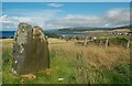
markj99 visited on 20th Jun 2019 - their rating: Cond: 4 Amb: 4 Access: 4 Bain's Hill is easy to visit with a good view over Turnberry Golf Course towards Ailsa Craig. Lunch at the Malin Court is also a good reason to stop.
")
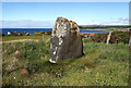
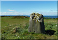
Quote from Canmore Canmore ID 40856: "The 'Stinnin Stane', a dolerite monolith, is situated at the S side of Maidenhead Bay, near Rab's Knowe (Pan Knowes) (J Smith 1895). This stone occupies a prominent position on top of a small hill. It measures 1.7m in height and 1.1m by 0.8m at the base. The name 'Stinnin Stane' is not in local use."
I parked in the grounds of a hotel Malin Court hotel, stone is a short walk from there, at the most northerly point of Turnberry golf course
You may be viewing yesterday's version of this page. To see the most up to date information please register for a free account.
")
")
Do not use the above information on other web sites or publications without permission of the contributor.
Nearby Images from Geograph Britain and Ireland:
©2019(licence)
©2008(licence)
©2019(licence)
©2018(licence)
©2016(licence)
The above images may not be of the site on this page, they are loaded from Geograph.
Please Submit an Image of this site or go out and take one for us!
Click here to see more info for this site
Nearby sites
Key: Red: member's photo, Blue: 3rd party photo, Yellow: other image, Green: no photo - please go there and take one, Grey: site destroyed
Download sites to:
KML (Google Earth)
GPX (GPS waypoints)
CSV (Garmin/Navman)
CSV (Excel)
To unlock full downloads you need to sign up as a Contributory Member. Otherwise downloads are limited to 50 sites.
Turn off the page maps and other distractions
Nearby sites listing. In the following links * = Image available
1.2km ESE 105° Shanter Knowe* Artificial Mound (NS21890738)
6.0km NE 53° Balchriston* Stone Fort or Dun (NS2572911176)
6.3km ESE 123° East Threave* Cairn (NS25870411)
8.0km ENE 57° Howmoor* Stone Fort or Dun (NS2770711809)
8.1km SE 131° Cairn Hill (Dalquharran)* Cairn (NS26690219)
8.8km ESE 116° Captain's Bridge (Drummochreen) W* Hillfort (NS28510356)
8.8km ESE 116° Captain's Bridge (Drummochreen) SE* Stone Fort or Dun (NS28530351)
9.1km E 90° Kildoon Hillfort* Hillfort (NS29860738)
10.2km SSE 147° Maxwelstone Camp* Hillfort (NX25959895)
10.5km ENE 73° Lyonston Stone* Standing Stone (Menhir) (NS30991039)
14.6km S 181° Dinvin Earthworks* Misc. Earthwork (NX2002993173)
15.2km ESE 116° Knockinculloch* Ancient Village or Settlement (NS34200050)
15.2km NE 52° Wallace's Stone (Blairstone Mains)* Early Christian Sculptured Stone (NS3321416579)
15.9km NE 44° Stonefield Park, Ayr* Standing Stone (Menhir) (NS32271869)
17.2km ENE 66° Barbieston Farm cist* Cist (NS36751417)
18.6km SE 133° Bencallen Hill* Chambered Cairn (NX33779440)
19.8km S 175° Glake Stone* Standing Stone (Menhir) (NX21678790)
21.7km NW 305° Kildonan (Arran)* Standing Stone (Menhir) (NS0337220870)
21.9km NW 313° Largybeg Point* Stone Circle (NS0536323338)
21.9km ESE 114° Cairnwhapple Stone* Natural Stone / Erratic / Other Natural Feature (NX40399796)
22.0km NE 37° Bruce's Well (Prestwick)* Holy Well or Sacred Spring (NS3467624801)
22.0km NW 310° Dippen (Arran)* Chambered Cairn (NS044226)
23.6km NW 314° Giant's Graves (Isle of Arran)* Chambered Cairn (NS0430424673)
23.8km SSE 164° Balmalloch Chambered Cairn* Chambered Cairn (NX2638784532)
24.0km SSE 164° Balmalloch Cairnfield* Barrow Cemetery (NX26488439)
View more nearby sites and additional images


 We would like to know more about this location. Please feel free to add a brief description and any relevant information in your own language.
 Wir möchten mehr über diese Stätte erfahren. Bitte zögern Sie nicht, eine kurze Beschreibung und relevante Informationen in Deutsch hinzuzufügen.
 Nous aimerions en savoir encore un peu sur les lieux. S'il vous plaît n'hesitez pas à ajouter une courte description et tous les renseignements pertinents dans votre propre langue.
 Quisieramos informarnos un poco más de las lugares. No dude en añadir una breve descripción y otros datos relevantes en su propio idioma.