


<< Our Photo Pages >> Dinvin Earthworks - Misc. Earthwork in Scotland in South Ayrshire
Submitted by Meglett on Thursday, 23 July 2015 Page Views: 4234
Multi-periodSite Name: Dinvin EarthworksCountry: Scotland
NOTE: This site is 2.1 km away from the location you searched for.
County: South Ayrshire Type: Misc. Earthwork
Nearest Town: Girvan
Map Ref: NX2002993173
Latitude: 55.199944N Longitude: 4.829367W
Condition:
| 5 | Perfect |
| 4 | Almost Perfect |
| 3 | Reasonable but with some damage |
| 2 | Ruined but still recognisable as an ancient site |
| 1 | Pretty much destroyed, possibly visible as crop marks |
| 0 | No data. |
| -1 | Completely destroyed |
| 5 | Superb |
| 4 | Good |
| 3 | Ordinary |
| 2 | Not Good |
| 1 | Awful |
| 0 | No data. |
| 5 | Can be driven to, probably with disabled access |
| 4 | Short walk on a footpath |
| 3 | Requiring a bit more of a walk |
| 2 | A long walk |
| 1 | In the middle of nowhere, a nightmare to find |
| 0 | No data. |
| 5 | co-ordinates taken by GPS or official recorded co-ordinates |
| 4 | co-ordinates scaled from a detailed map |
| 3 | co-ordinates scaled from a bad map |
| 2 | co-ordinates of the nearest village |
| 1 | co-ordinates of the nearest town |
| 0 | no data |
Internal Links:
External Links:
")
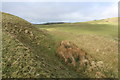
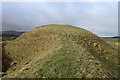
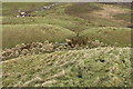
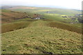
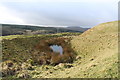
Approx. three miles inland from Girvan on A714 and visible as a strange hump from the road. No real path but access is an easy climb uphill (avoiding livestock if present), and round to far side to cross to top section. The ramparts are steep, up to 15 ft in places.
This is one of the best preserved hillforts in Scotland, and well worth a visit.
Update June 2017: Further information can be found on Canmore site 62643 which describes this as a motte of medieval date, which: "occupies a commanding position on a hilltop 600m SE of Pinmacher and stands to a height of up to 7.5m within double ditches and external banks; a causeway spans the inner ditch on the ESE ... for many years the scale of the defences led scholars to believe that the site was of iron-age date, and such a view was reinforced by the very name Divin, with the Celtic element dun suggesting a fortified site."
You may be viewing yesterday's version of this page. To see the most up to date information please register for a free account.
")
")
")
Do not use the above information on other web sites or publications without permission of the contributor.
Nearby Images from Geograph Britain and Ireland:
©2016(licence)
©2016(licence)
©2016(licence)
©2016(licence)
©2016(licence)
The above images may not be of the site on this page, they are loaded from Geograph.
Please Submit an Image of this site or go out and take one for us!
Click here to see more info for this site
Nearby sites
Key: Red: member's photo, Blue: 3rd party photo, Yellow: other image, Green: no photo - please go there and take one, Grey: site destroyed
Download sites to:
KML (Google Earth)
GPX (GPS waypoints)
CSV (Garmin/Navman)
CSV (Excel)
To unlock full downloads you need to sign up as a Contributory Member. Otherwise downloads are limited to 50 sites.
Turn off the page maps and other distractions
Nearby sites listing. In the following links * = Image available
5.5km SSE 160° Glake Stone* Standing Stone (Menhir) (NX21678790)
6.5km ENE 75° Auchensoul Hill* Cairn (NX26399455)
8.3km NE 43° Maxwelstone Camp* Hillfort (NX25959895)
8.5km N 357° Witching Stone (Dipple)* Standing Stone (Menhir) (NS19920173)
10.7km SE 141° Balmalloch Chambered Cairn* Chambered Cairn (NX2638784532)
10.8km ENE 75° Knockeen Cairn* Cairn (NX30609552)
10.9km SE 141° Balmalloch Cairnfield* Barrow Cemetery (NX26488439)
10.9km SSE 168° Barrhill White Cairn* Cairn (NX21898244)
11.2km S 189° Arecleoch Standing Stone* Standing Stone (Menhir) (NX178822)
11.2km NE 34° Cairn Hill (Dalquharran)* Cairn (NS26690219)
11.5km SSE 150° Laggan Cairn (Barrhill)* Cairn (NX25358297)
11.6km SW 224° Duniewick* Hillfort (NX11628515)
12.0km SW 224° Knockdolian* Cairn (NX1132784805)
12.4km NNE 26° East Threave* Cairn (NS25870411)
13.4km NE 37° Captain's Bridge (Drummochreen) SE* Stone Fort or Dun (NS28530351)
13.4km NE 37° Captain's Bridge (Drummochreen) W* Hillfort (NS28510356)
13.8km E 83° Bencallen Hill* Chambered Cairn (NX33779440)
14.0km S 185° Cave Cairn (Chirmorrie)* Chambered Cairn (NX18317924)
14.3km N 5° Shanter Knowe* Artificial Mound (NS21890738)
14.6km N 1° Bains Hill* Standing Stone (Menhir) (NS20750773)
14.7km E 86° Pinbreck Hill* Cairn (NX34809371)
14.8km SSE 166° Laggish White Cairn* Cairn (NX22987860)
15.1km S 187° Arecleoch Chambered Cairn Chambered Cairn (NX175783)
15.9km ENE 60° Knockinculloch* Ancient Village or Settlement (NS34200050)
16.1km SW 222° Garleffin* Stone Row / Alignment (NX08738172)
View more nearby sites and additional images


 We would like to know more about this location. Please feel free to add a brief description and any relevant information in your own language.
 Wir möchten mehr über diese Stätte erfahren. Bitte zögern Sie nicht, eine kurze Beschreibung und relevante Informationen in Deutsch hinzuzufügen.
 Nous aimerions en savoir encore un peu sur les lieux. S'il vous plaît n'hesitez pas à ajouter une courte description et tous les renseignements pertinents dans votre propre langue.
 Quisieramos informarnos un poco más de las lugares. No dude en añadir una breve descripción y otros datos relevantes en su propio idioma.