<< Our Photo Pages >> The Beacon Cist - Cist in England in Cornwall
Submitted by TheCaptain on Sunday, 10 February 2019 Page Views: 944
Neolithic and Bronze AgeSite Name: The Beacon CistCountry: England
NOTE: This site is 0.3 km away from the location you searched for.
County: Cornwall Type: Cist
Nearest Town: Launceston Nearest Village: Altarnun
Map Ref: SX19667944
Latitude: 50.586771N Longitude: 4.548945W
Condition:
| 5 | Perfect |
| 4 | Almost Perfect |
| 3 | Reasonable but with some damage |
| 2 | Ruined but still recognisable as an ancient site |
| 1 | Pretty much destroyed, possibly visible as crop marks |
| 0 | No data. |
| -1 | Completely destroyed |
| 5 | Superb |
| 4 | Good |
| 3 | Ordinary |
| 2 | Not Good |
| 1 | Awful |
| 0 | No data. |
| 5 | Can be driven to, probably with disabled access |
| 4 | Short walk on a footpath |
| 3 | Requiring a bit more of a walk |
| 2 | A long walk |
| 1 | In the middle of nowhere, a nightmare to find |
| 0 | No data. |
| 5 | co-ordinates taken by GPS or official recorded co-ordinates |
| 4 | co-ordinates scaled from a detailed map |
| 3 | co-ordinates scaled from a bad map |
| 2 | co-ordinates of the nearest village |
| 1 | co-ordinates of the nearest town |
| 0 | no data |
Internal Links:
External Links:
I have visited· I would like to visit
TheCaptain has visited here
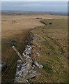
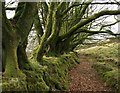
Walking down from the top of The Beacon towards the Black Rock and then on to the moor entrance at Westmoorgate, I notice lots of lumps and bumps in the moorland up here, clearly not natural. I think some of it is possibly the remains of some sort of mining or quarrying activity, but at one point I find what looks like it may be the remains of a cist within a small cairn, but its not a typical place for such a thing to be found.
However, there appear to be remnants of hut circles around here, and the known large cairns up at the top of the hill, and with the fabulous remains all over the nearby Leskernick Hill, I wouldn't be at all surprised if this hill was once as occupied and lived on as that.
You may be viewing yesterday's version of this page. To see the most up to date information please register for a free account.
Do not use the above information on other web sites or publications without permission of the contributor.
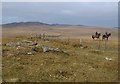
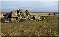
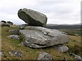
Nearby Images from Geograph Britain and Ireland:
©2008(licence)
©2008(licence)
©2008(licence)
©2008(licence)
©2008(licence)
The above images may not be of the site on this page, they are loaded from Geograph.
Please Submit an Image of this site or go out and take one for us!
Click here to see more info for this site
Nearby sites
Key: Red: member's photo, Blue: 3rd party photo, Yellow: other image, Green: no photo - please go there and take one, Grey: site destroyed
Download sites to:
KML (Google Earth)
GPX (GPS waypoints)
CSV (Garmin/Navman)
CSV (Excel)
To unlock full downloads you need to sign up as a Contributory Member. Otherwise downloads are limited to 50 sites.
Turn off the page maps and other distractions
Nearby sites listing. In the following links * = Image available
160m S 174° The Beacon Cairns* Cairn (SX19677928)
405m SSW 194° Elephant Rock* Natural Stone / Erratic / Other Natural Feature (SX19557905)
861m WNW 281° Leskernick SE* Stone Circle (SX18827964)
923m WNW 297° Leskernick Hill Row* Stone Row / Alignment (SX1884979885)
977m SW 234° Trezelland stone setting* Standing Stones (SX18857889)
1.0km WNW 289° Leskernick* Ancient Village or Settlement (SX18717980)
1.0km WNW 289° Leskernick cairn* Cairn (SX18687982)
1.2km WNW 292° Leskernick NW* Stone Circle (SX18587992)
1.4km NNW 337° Westmoor Cairns* Cairn (SX19178070)
1.4km WNW 284° Leskernick cist* Cist (SX18307983)
1.4km NNE 23° Westmoorgate circle* Stone Circle (SX20258073)
1.4km WNW 291° Leskernick Hill Settlement* Ancient Village or Settlement (SX18358000)
1.5km WNW 295° Leskernick 2* Natural Stone / Erratic / Other Natural Feature (SX1829880125)
1.5km NNE 19° Westmoorgate cairn* Cairn (SX2020680866)
1.6km WNW 297° Leskernick Quoit* Natural Stone / Erratic / Other Natural Feature (SX1827980202)
1.6km WNW 302° Leskernick Hill cairn* Cairn (SX18328035)
1.6km E 85° Spettigue Menhir* Standing Stone (Menhir) (SX21307952)
1.6km N 5° West Moor Possible Menhir* Standing Stone (Menhir) (SX1987081077)
2.1km S 172° Carneglos row* Stone Row / Alignment (SX19887737)
2.3km SSE 162° Carneglos Barrow* Ring Cairn (SX20287725)
2.3km S 171° Carneglos settlement* Ancient Village or Settlement (SX19957715)
2.3km SW 221° Tolborough Standing Stone* Standing Stone (Menhir) (SX1807877741)
2.6km WSW 248° Catshole Quoit* Chambered Tomb (SX17227856)
2.6km SW 231° Tolborough Tor stone row* Stone Row / Alignment (SX17547787)
2.6km SW 232° Tolborough Tor Cairn* Cairn (SX175779)
View more nearby sites and additional images


 We would like to know more about this location. Please feel free to add a brief description and any relevant information in your own language.
 Wir möchten mehr über diese Stätte erfahren. Bitte zögern Sie nicht, eine kurze Beschreibung und relevante Informationen in Deutsch hinzuzufügen.
 Nous aimerions en savoir encore un peu sur les lieux. S'il vous plaît n'hesitez pas à ajouter une courte description et tous les renseignements pertinents dans votre propre langue.
 Quisieramos informarnos un poco más de las lugares. No dude en añadir una breve descripción y otros datos relevantes en su propio idioma.