


<< Text Pages >> Catshole Tor Cairn - Cairn in England in Cornwall
Submitted by dooclay on Thursday, 04 September 2025 Page Views: 269
Neolithic and Bronze AgeSite Name: Catshole Tor CairnCountry: England County: Cornwall Type: Cairn
Nearest Village: Altarnun
Map Ref: SX1700078485
Latitude: 50.577364N Longitude: 4.586011W
Condition:
| 5 | Perfect |
| 4 | Almost Perfect |
| 3 | Reasonable but with some damage |
| 2 | Ruined but still recognisable as an ancient site |
| 1 | Pretty much destroyed, possibly visible as crop marks |
| 0 | No data. |
| -1 | Completely destroyed |
| 5 | Superb |
| 4 | Good |
| 3 | Ordinary |
| 2 | Not Good |
| 1 | Awful |
| 0 | No data. |
| 5 | Can be driven to, probably with disabled access |
| 4 | Short walk on a footpath |
| 3 | Requiring a bit more of a walk |
| 2 | A long walk |
| 1 | In the middle of nowhere, a nightmare to find |
| 0 | No data. |
| 5 | co-ordinates taken by GPS or official recorded co-ordinates |
| 4 | co-ordinates scaled from a detailed map |
| 3 | co-ordinates scaled from a bad map |
| 2 | co-ordinates of the nearest village |
| 1 | co-ordinates of the nearest town |
| 0 | no data |
Internal Links:
External Links:
Cairn in Cornwall
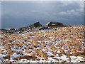
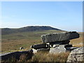
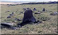
Source, Cornwall HER: The disturbed remains of a cairn 15.5m in diameter, with evidence of a boulder kerb.
You may be viewing yesterday's version of this page. To see the most up to date information please register for a free account.
")
Do not use the above information on other web sites or publications without permission of the contributor.
Nearby Images from Geograph Britain and Ireland:
©2010(licence)
©2008(licence)
©2012(licence)
©2014(licence)

©2010(licence)
The above images may not be of the site on this page, they are loaded from Geograph.
Please Submit an Image of this site or go out and take one for us!
Click here to see more info for this site
Nearby sites
Key: Red: member's photo, Blue: 3rd party photo, Yellow: other image, Green: no photo - please go there and take one, Grey: site destroyed
Download sites to:
KML (Google Earth)
GPX (GPS waypoints)
CSV (Garmin/Navman)
CSV (Excel)
To unlock full downloads you need to sign up as a Contributory Member. Otherwise downloads are limited to 50 sites.
Turn off the page maps and other distractions
Nearby sites listing. In the following links * = Image available
232m ENE 69° Catshole Quoit* Chambered Tomb (SX17227856)
272m SE 131° Catshole Downs long cairn* Chambered Cairn (SX172783)
768m SE 138° Tolborough Tor Cairn* Cairn (SX175779)
817m SE 137° Tolborough Tor stone row* Stone Row / Alignment (SX17547787)
1.3km NW 318° Brown Willy Settlement* Ancient Village or Settlement (SX16157948)
1.3km ESE 123° Tolborough Standing Stone* Standing Stone (Menhir) (SX1807877741)
1.6km NW 316° Brown Willy Cairn S* Cairn (SX15927968)
1.9km NE 42° Leskernick cist* Cist (SX18307983)
1.9km NW 321° Brown Willy Barrow Cemetery* Barrow Cemetery (SX15877999)
1.9km ENE 76° Trezelland stone setting* Standing Stones (SX18857889)
2.0km WNW 295° Fernacre Settlement 2 Ancient Village or Settlement (SX15227938)
2.0km NE 40° Leskernick Hill Settlement* Ancient Village or Settlement (SX18358000)
2.1km NE 36° Leskernick 2* Natural Stone / Erratic / Other Natural Feature (SX1829880125)
2.1km NE 46° Leskernick NW* Stone Circle (SX18587992)
2.1km NE 35° Leskernick Quoit* Natural Stone / Erratic / Other Natural Feature (SX1827980202)
2.1km NE 49° Leskernick cairn* Cairn (SX18687982)
2.2km NE 56° Leskernick SE* Stone Circle (SX18827964)
2.2km NE 50° Leskernick* Ancient Village or Settlement (SX18717980)
2.3km WSW 239° Butterstor Ancient Village or Settlement (SX150774)
2.3km NNE 33° Leskernick Hill cairn* Cairn (SX18328035)
2.3km NE 51° Leskernick Hill Row* Stone Row / Alignment (SX1884979885)
2.5km W 266° Propped stones on Garrow Tor* Natural Stone / Erratic / Other Natural Feature (SX145784)
2.5km WNW 302° Fernacre Settlement 1* Ancient Village or Settlement (SX14937990)
2.5km WSW 257° Garrow Tor* Ancient Village or Settlement (SX145780)
2.6km WNW 289° Fernacre Cairn 3 Cairn (SX14607942)
View more nearby sites and additional images


 We would like to know more about this location. Please feel free to add a brief description and any relevant information in your own language.
 Wir möchten mehr über diese Stätte erfahren. Bitte zögern Sie nicht, eine kurze Beschreibung und relevante Informationen in Deutsch hinzuzufügen.
 Nous aimerions en savoir encore un peu sur les lieux. S'il vous plaît n'hesitez pas à ajouter une courte description et tous les renseignements pertinents dans votre propre langue.
 Quisieramos informarnos un poco más de las lugares. No dude en añadir una breve descripción y otros datos relevantes en su propio idioma.