<< Our Photo Pages >> Tich Barrow Tumuli - Barrow Cemetery in England in Cornwall
Submitted by dooclay on Sunday, 23 October 2022 Page Views: 424
Neolithic and Bronze AgeSite Name: Tich Barrow Tumuli Alternative Name: Tites-BurghdonCountry: England County: Cornwall Type: Barrow Cemetery
Nearest Town: Launceston Nearest Village: Davidstow
Map Ref: SX14678810
Latitude: 50.663004N Longitude: 4.623688W
Condition:
| 5 | Perfect |
| 4 | Almost Perfect |
| 3 | Reasonable but with some damage |
| 2 | Ruined but still recognisable as an ancient site |
| 1 | Pretty much destroyed, possibly visible as crop marks |
| 0 | No data. |
| -1 | Completely destroyed |
| 5 | Superb |
| 4 | Good |
| 3 | Ordinary |
| 2 | Not Good |
| 1 | Awful |
| 0 | No data. |
| 5 | Can be driven to, probably with disabled access |
| 4 | Short walk on a footpath |
| 3 | Requiring a bit more of a walk |
| 2 | A long walk |
| 1 | In the middle of nowhere, a nightmare to find |
| 0 | No data. |
| 5 | co-ordinates taken by GPS or official recorded co-ordinates |
| 4 | co-ordinates scaled from a detailed map |
| 3 | co-ordinates scaled from a bad map |
| 2 | co-ordinates of the nearest village |
| 1 | co-ordinates of the nearest town |
| 0 | no data |
Internal Links:
External Links:
")
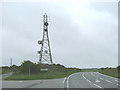
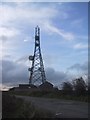
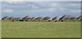
HER Number: 2230.10, Large barrow in a layby by a Telecommunications mast and with a concrete watertank built into it. Forms a group with
HER Number: 2230.20, SX 1453 8811
'Central barrow in an east-west alignment of three barrows which includes Tichbarrow'. from HER
And, HER Number: 2230.30, SX 1451 8811
You may be viewing yesterday's version of this page. To see the most up to date information please register for a free account.
")
Do not use the above information on other web sites or publications without permission of the contributor.
Nearby Images from Geograph Britain and Ireland:
©2006(licence)
©2008(licence)
©2019(licence)
©2020(licence)
©2008(licence)
The above images may not be of the site on this page, they are loaded from Geograph.
Please Submit an Image of this site or go out and take one for us!
Click here to see more info for this site
Nearby sites
Key: Red: member's photo, Blue: 3rd party photo, Yellow: other image, Green: no photo - please go there and take one, Grey: site destroyed
Download sites to:
KML (Google Earth)
GPX (GPS waypoints)
CSV (Garmin/Navman)
CSV (Excel)
To unlock full downloads you need to sign up as a Contributory Member. Otherwise downloads are limited to 50 sites.
Turn off the page maps and other distractions
Nearby sites listing. In the following links * = Image available
344m NNE 24° Hendra Tumuli* Barrow Cemetery (SX14828841)
882m SE 144° Davidstow Well* Holy Well or Sacred Spring (SX1516187366)
1.5km W 271° Hendraburnick Quoit* Chambered Cairn (SX13218818)
2.0km SSW 212° Nettings Park Barrows* Round Barrow(s) (SX13578648)
2.2km SW 219° Starapark Barrows* Barrow Cemetery (SX13188642)
2.4km NW 307° Tregrylls Cross* Ancient Cross (SX1281989619)
2.7km NW 320° Lesnewth Cross* Ancient Cross (SX130902)
3.2km ESE 113° Lambrenny Cross* Ancient Cross (SX17558677)
3.5km W 278° Tregatherall Barrow* Round Barrow(s) (SX11258870)
3.5km W 267° Waterpit Down* Ancient Cross (SX11198807)
3.7km NNW 329° St Juliot's Churchyard* Ancient Cross (SX129913)
4.0km ENE 76° Wilsey Down Tumuli* Barrow Cemetery (SX18608896)
4.2km SSE 157° Davidstow Moor Barrow* Round Barrow(s) (SX16168417)
4.2km NNW 336° Cargurra Camp* Ancient Village or Settlement (SX131920)
4.3km WNW 303° St Mathiana's Well* Holy Well or Sacred Spring (SX111906)
4.5km SW 234° King Arthur Stone* Early Christian Sculptured Stone (SX109856)
4.7km SW 234° Slaughterbridge Enclosure Misc. Earthwork (SX108855)
4.8km SSE 151° Trevillian's Gate Barrow* Round Barrow(s) (SX16858384)
4.8km S 190° Advent Triple Barrow* Round Cairn (SX137834)
5.0km S 189° LowerMoor Tumuli* Barrow Cemetery (SX137832)
5.0km SSE 149° Newpark Cross* Ancient Cross (SX17148372)
5.3km NNW 344° Higher Pennycrocker Barrows* Round Barrow(s) (SX1341093211)
5.4km SSW 198° Higher Parkwalls Tumulus* Round Barrow(s) (SX128830)
5.5km ESE 102° Tregulland Barrow Cup Marks (Trenglos) Rock Art (SX20018674)
5.5km SW 217° Tregoodwell Cross* Ancient Cross (SX11228380)
View more nearby sites and additional images


 We would like to know more about this location. Please feel free to add a brief description and any relevant information in your own language.
 Wir möchten mehr über diese Stätte erfahren. Bitte zögern Sie nicht, eine kurze Beschreibung und relevante Informationen in Deutsch hinzuzufügen.
 Nous aimerions en savoir encore un peu sur les lieux. S'il vous plaît n'hesitez pas à ajouter une courte description et tous les renseignements pertinents dans votre propre langue.
 Quisieramos informarnos un poco más de las lugares. No dude en añadir una breve descripción y otros datos relevantes en su propio idioma.