<< Our Photo Pages >> Glenterrow Cairn - Cairn in Scotland in Dumfries and Galloway
Submitted by markj99 on Sunday, 01 November 2020 Page Views: 448
Neolithic and Bronze AgeSite Name: Glenterrow Cairn Alternative Name: Glentirrow CairnCountry: Scotland County: Dumfries and Galloway Type: Cairn
Nearest Town: Stranraer Nearest Village: New Luce
Map Ref: NX14506256
Latitude: 54.923163N Longitude: 4.896197W
Condition:
| 5 | Perfect |
| 4 | Almost Perfect |
| 3 | Reasonable but with some damage |
| 2 | Ruined but still recognisable as an ancient site |
| 1 | Pretty much destroyed, possibly visible as crop marks |
| 0 | No data. |
| -1 | Completely destroyed |
| 5 | Superb |
| 4 | Good |
| 3 | Ordinary |
| 2 | Not Good |
| 1 | Awful |
| 0 | No data. |
| 5 | Can be driven to, probably with disabled access |
| 4 | Short walk on a footpath |
| 3 | Requiring a bit more of a walk |
| 2 | A long walk |
| 1 | In the middle of nowhere, a nightmare to find |
| 0 | No data. |
| 5 | co-ordinates taken by GPS or official recorded co-ordinates |
| 4 | co-ordinates scaled from a detailed map |
| 3 | co-ordinates scaled from a bad map |
| 2 | co-ordinates of the nearest village |
| 1 | co-ordinates of the nearest town |
| 0 | no data |
Internal Links:
External Links:
")
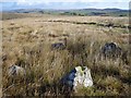
Glenterrow Cairn is an almost destroyed cairn 50 metres NW of Glenterrow Four Poster. It is in the SW corner of a rectangular field on the edge of moorland. The cairn, 20 yards across, has been reduced to ground level with the exceptions being a 1 foot high earth bank running 90 degrees from SW to NW and a 2 feet high earth bank running 45 degrees from E to SE. The cairn has been stripped of stones except for a clump of stones at the NW point of the bank. There is a large boulder measuring 0.9 x 0.8 x 0.4 metres, a possible kerb stone, with three smaller stones.
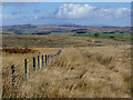
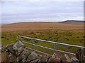
It is only a matter of 50 metres SE to Glenterrow Four Poster lying in moorland beyond the fence. This is the easiest and driest route to Glenterrow Four Poster which is now un-signposted and unloved.
The real significance of this cairn is not its condition but its location. Its proximity to the four poster raises the question of the relationship between the two monuments. Were they built at the same time or do they represent different phases of occupation?
A Canmore search for Glenterrow produces Glenterrow Cairn as Canmore ID 61689 as well as two other destroyed cairns within a 500 metre radius.
This changes Glenterrow Four Poster from an isolated site to a site surrounded by other monuments.
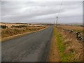
Directions: Take the New Luce turn off the A75 at the E end of Castle Kennedy village. After 3.5 miles there is a gateway on the L at NX 1478 6240. There is a farm track leading N at first then bearing NW into a gateway at a boggy corner. Go through the gate and head SW up the field parallel to the fence for 350 yards. Glenterrow Cairn is in the SW corner of the field.
You may be viewing yesterday's version of this page. To see the most up to date information please register for a free account.
")
")
")
Do not use the above information on other web sites or publications without permission of the contributor.
Nearby Images from Geograph Britain and Ireland:
©2007(licence)
©2007(licence)
©2011(licence)
©2011(licence)
©2011(licence)
The above images may not be of the site on this page, they are loaded from Geograph.
Please Submit an Image of this site or go out and take one for us!
Click here to see more info for this site
Nearby sites
Key: Red: member's photo, Blue: 3rd party photo, Yellow: other image, Green: no photo - please go there and take one, Grey: site destroyed
Download sites to:
KML (Google Earth)
GPX (GPS waypoints)
CSV (Garmin/Navman)
CSV (Excel)
To unlock full downloads you need to sign up as a Contributory Member. Otherwise downloads are limited to 50 sites.
Turn off the page maps and other distractions
Nearby sites listing. In the following links * = Image available
58m SSE 147° Glentirrow* Stone Circle (NX14536251)
610m SSW 199° Glenterrow White Cairn (Destroyed)* Cairn (NX14286199)
2.5km NE 56° Mains of Larg cairn* Cairn (NX16616385)
2.6km NNW 336° Auld Wife's Grave* Chambered Cairn (NX13536498)
2.7km E 86° Cairn McNeilie* Cairn (NX17246266)
3.0km NE 36° Mains of Larg NW* Cairn (NX16356493)
3.1km NE 36° Mains of Larg NE* Cairn (NX16406497)
3.2km SW 227° Cults Loch* Crannog (NX12066047)
3.2km NNE 32° Gowk Nest Wood* Cairn (NX16306523)
3.3km E 89° Littlepark* Cairn (NX17836250)
3.4km WSW 244° Black Loch Crannog* Crannog (NX11396118)
3.4km ENE 57° Lady Well (New Luce) Holy Well or Sacred Spring (NX17466432)
3.4km E 94° Cruise Back Fell* Hillfort (NX17946219)
3.5km NNW 343° Cairnerzean Fell South* Cairn (NX13616595)
3.5km SE 126° Craig Fell N* Cairn (NX17296039)
3.7km NNW 348° Cairnerzean Fell Central* Cairn (NX13866620)
3.7km ENE 74° Cruise W* Cairn (NX18116342)
3.8km N 359° Lingdowey Burn S* Cairn (NX14616635)
3.8km ENE 74° Cruise E* Cairn (NX18236348)
3.9km NNW 348° Cairnerzean Fell N* Cairn (NX13836642)
3.9km N 356° Lingdowey Burn N* Cairn (NX14416649)
4.1km SE 139° Airyhemming W* Cairn (NX17055938)
4.2km SE 136° Airyhemming E* Cairn (NX17265943)
4.2km WNW 294° Balker Moor S Cairn (NX10766444)
4.2km NNW 345° Cairnerzean Fell Summit* Cairn (NX13606668)
View more nearby sites and additional images


 We would like to know more about this location. Please feel free to add a brief description and any relevant information in your own language.
 Wir möchten mehr über diese Stätte erfahren. Bitte zögern Sie nicht, eine kurze Beschreibung und relevante Informationen in Deutsch hinzuzufügen.
 Nous aimerions en savoir encore un peu sur les lieux. S'il vous plaît n'hesitez pas à ajouter une courte description et tous les renseignements pertinents dans votre propre langue.
 Quisieramos informarnos un poco más de las lugares. No dude en añadir una breve descripción y otros datos relevantes en su propio idioma.