<< Text Pages >> Chapel Wells (Mull of Galloway) - Holy Well or Sacred Spring in Scotland in Dumfries and Galloway
Submitted by Anne T on Sunday, 03 July 2022 Page Views: 783
Springs and Holy WellsSite Name: Chapel Wells (Mull of Galloway) Alternative Name: St Medan's Chapel WellsCountry: Scotland County: Dumfries and Galloway Type: Holy Well or Sacred Spring
Nearest Town: Port Logan Nearest Village: Mull of Galloway
Map Ref: NX14393159
Latitude: 54.645165N Longitude: 4.878087W
Condition:
| 5 | Perfect |
| 4 | Almost Perfect |
| 3 | Reasonable but with some damage |
| 2 | Ruined but still recognisable as an ancient site |
| 1 | Pretty much destroyed, possibly visible as crop marks |
| 0 | No data. |
| -1 | Completely destroyed |
| 5 | Superb |
| 4 | Good |
| 3 | Ordinary |
| 2 | Not Good |
| 1 | Awful |
| 0 | No data. |
| 5 | Can be driven to, probably with disabled access |
| 4 | Short walk on a footpath |
| 3 | Requiring a bit more of a walk |
| 2 | A long walk |
| 1 | In the middle of nowhere, a nightmare to find |
| 0 | No data. |
| 5 | co-ordinates taken by GPS or official recorded co-ordinates |
| 4 | co-ordinates scaled from a detailed map |
| 3 | co-ordinates scaled from a bad map |
| 2 | co-ordinates of the nearest village |
| 1 | co-ordinates of the nearest town |
| 0 | no data |
Be the first person to rate this site - see the 'Contribute!' box in the right hand menu.
Internal Links:
External Links:
I have visited· I would like to visit
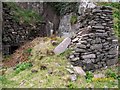
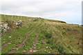
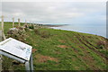
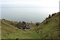
peterhewitt visited on 16th Mar 2021 - their rating: Cond: 5 Amb: 5 Access: 1 Fabulous site, Chapel and cave just around the corner. Local display board says don't attempt approach to wells and Chapel without a guide. Good advice as it is very steep... the wells were historically accesed by boat. However it is the jewel in the crown of holy wells, in my opinion!
Recorded as three holy wells in Canmore's Site ID 61045, the wells were described in 1912 as "three natural cavities in a rock, which are filled by the sea at high tide. Thet largest is 5ft in diameter and 4-5ft deep. The other wells almost touch it and are about 1ft 8ins in width and depth. They were formerly much resorted to be sick people, particularly on the first Sunday of May, gifts being left at the chapel."
A site visit made in 1972 adds: "The wells were not seen, the site being visited at high tide. Local informants stated that they are still visible and were last used around 1940."
St Medan's Cave and the ruins of his chapel can be found at NX 1437 3159, and are recorded as Canmore Site ID 61044.
Does anyone have any more information about these wells, and what diseases/sickness they were/are reputed to cure? Has anyone visited this site, can confirm that the wells still exist, and have photographs they could add? Thank you.
You may be viewing yesterday's version of this page. To see the most up to date information please register for a free account.
 (PID:259918)")
 (PID:259917)")
 (PID:259919)")
Do not use the above information on other web sites or publications without permission of the contributor.
Nearby Images from Geograph Britain and Ireland:
©2010(licence)
©2013(licence)
©2013(licence)
©2013(licence)

©2013(licence)
The above images may not be of the site on this page, they are loaded from Geograph.
Please Submit an Image of this site or go out and take one for us!
Click here to see more info for this site
Nearby sites
Key: Red: member's photo, Blue: 3rd party photo, Yellow: other image, Green: no photo - please go there and take one, Grey: site destroyed
Download sites to:
KML (Google Earth)
GPX (GPS waypoints)
CSV (Garmin/Navman)
CSV (Excel)
To unlock full downloads you need to sign up as a Contributory Member. Otherwise downloads are limited to 50 sites.
Turn off the page maps and other distractions
Nearby sites listing. In the following links * = Image available
741m SSE 168° Mull Of Galloway Earthworks* Ancient Village or Settlement (NX14523086)
854m S 178° Mull of Galloway* Ancient Village or Settlement (NX1438130735)
1.0km WSW 249° West Cairngaan stone* Standing Stone (Menhir) (NX13393126)
1.2km W 268° Kibbertie Kite Well (West Cairngaan) Holy Well or Sacred Spring (NX13193160)
1.7km SE 129° Lagvag Cairn* Cairn (NX15683044)
3.9km WNW 302° Muntloch Well (Drummore) Holy Well or Sacred Spring (NX11153384)
4.8km NNW 345° Lady Well (Low Drummore) Holy Well or Sacred Spring (NX13303626)
5.6km NNW 337° Core Hill* Hillfort (NX12433686)
6.0km WNW 292° Crammag Head* Promontory Fort / Cliff Castle (NX08913404)
6.1km NW 316° Cairn Fell* Cairn (NX10333612)
6.7km NNW 343° Kilstay* Standing Stone (Menhir) (NX1273738072)
8.5km NNW 335° Inchmulloch Hill* Standing Stone (Menhir) (NX1113739421)
8.7km NNW 342° St Bride's Well (Kirkmaiden Parish) Holy Well or Sacred Spring (NX1240)
9.9km NNW 345° Terally Bay* Standing Stone (Menhir) (NX12284127)
10.6km NNW 344° Chipperdingan Well (New England Bay) Holy Well or Sacred Spring (NX11904190)
12.2km NNW 335° St Mary's Well (Logan) Holy Well or Sacred Spring (NX096428)
12.6km NNW 338° Logan House* Standing Stone (Menhir) (NX10224354)
13.9km NNW 329° Grennan Point* Promontory Fort / Cliff Castle (NX07604377)
15.2km NNW 327° Doon Castle (Broch)* Broch or Nuraghe (NX0670244683)
17.1km NNW 332° Craigencroy* Cairn (NX07064711)
17.9km NNW 339° Cairnweil standing stone* Standing Stone (Menhir) (NX0863748556)
17.9km NNW 337° Kirkmadrine Church Stones* Early Christian Sculptured Stone (NX0801448389)
18.5km NNW 334° Mid Float E* Standing Stone (Menhir) (NX06804851)
18.5km NNW 333° Mid Float W* Natural Stone / Erratic / Other Natural Feature (NX06584844)
19.0km NNW 334° Whirlpool* Standing Stone (Menhir) (NX06624898)
View more nearby sites and additional images


 We would like to know more about this location. Please feel free to add a brief description and any relevant information in your own language.
 Wir möchten mehr über diese Stätte erfahren. Bitte zögern Sie nicht, eine kurze Beschreibung und relevante Informationen in Deutsch hinzuzufügen.
 Nous aimerions en savoir encore un peu sur les lieux. S'il vous plaît n'hesitez pas à ajouter une courte description et tous les renseignements pertinents dans votre propre langue.
 Quisieramos informarnos un poco más de las lugares. No dude en añadir una breve descripción y otros datos relevantes en su propio idioma.