


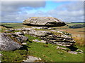
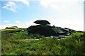
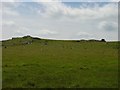
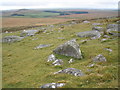
<< Our Photo Pages >> Louden Long Cairn - Long Barrow in England in Cornwall
Submitted by coldrum on Tuesday, 13 October 2009 Page Views: 4272
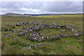
Neolithic and Bronze AgeSite Name: Louden Long CairnCountry: England County: Cornwall Type: Long Barrow
Map Ref: SX14028032
Latitude: 50.592907N Longitude: 4.628972W
Condition:
| 5 | Perfect |
| 4 | Almost Perfect |
| 3 | Reasonable but with some damage |
| 2 | Ruined but still recognisable as an ancient site |
| 1 | Pretty much destroyed, possibly visible as crop marks |
| 0 | No data. |
| -1 | Completely destroyed |
| 5 | Superb |
| 4 | Good |
| 3 | Ordinary |
| 2 | Not Good |
| 1 | Awful |
| 0 | No data. |
| 5 | Can be driven to, probably with disabled access |
| 4 | Short walk on a footpath |
| 3 | Requiring a bit more of a walk |
| 2 | A long walk |
| 1 | In the middle of nowhere, a nightmare to find |
| 0 | No data. |
| 5 | co-ordinates taken by GPS or official recorded co-ordinates |
| 4 | co-ordinates scaled from a detailed map |
| 3 | co-ordinates scaled from a bad map |
| 2 | co-ordinates of the nearest village |
| 1 | co-ordinates of the nearest town |
| 0 | no data |
Internal Links:
External Links:
I have visited· I would like to visit
LiveAndrew visited on 26th Aug 2021 - their rating: Cond: 2 Amb: 4 Access: 3
")
Source: HER Record
You may be viewing yesterday's version of this page. To see the most up to date information please register for a free account.
")
")
")
")
Do not use the above information on other web sites or publications without permission of the contributor.
Nearby Images from Geograph Britain and Ireland:
©2017(licence)
©2010(licence)
©2005(licence)
©2008(licence)
©2014(licence)
The above images may not be of the site on this page, they are loaded from Geograph.
Please Submit an Image of this site or go out and take one for us!
Click here to see more info for this site
Nearby sites
Key: Red: member's photo, Blue: 3rd party photo, Yellow: other image, Green: no photo - please go there and take one, Grey: site destroyed
Download sites to:
KML (Google Earth)
GPX (GPS waypoints)
CSV (Garmin/Navman)
CSV (Excel)
To unlock full downloads you need to sign up as a Contributory Member. Otherwise downloads are limited to 50 sites.
Turn off the page maps and other distractions
Nearby sites listing. In the following links * = Image available
123m WSW 254° Loudon Hill Settlement* Ancient Village or Settlement (SX13908029)
231m W 261° Louden Hill Cairns* Cairn (SX13798029)
281m WNW 285° Louden Tor* Natural Stone / Erratic / Other Natural Feature (SX13758040)
322m NNW 332° Louden Hill 1 Cairn (SX13888061)
447m N 8° Loudon Hill 2* Cairn (SX14108076)
479m E 90° Roughtor South* Ancient Village or Settlement (SX145803)
540m NW 319° Stannon Down Cairn (SX13688074)
549m WNW 287° Louden Hill 3 Ancient Village or Settlement (SX135805)
563m SE 125° Fernacre* Stone Circle (SX14477998)
563m N 352° Stannon Down 1* Cairn (SX13968088)
579m SSW 193° Louden Hill Cists* Cairn (SX13877976)
582m SSW 194° Louden Hill Cairn 2* Cairn (SX13867976)
610m SSW 210° Louden south* Ancient Village or Settlement (SX137798)
614m SSW 200° Louden 2* Cairn (SX13797975)
628m ESE 121° Fernacre Outlier* Standing Stone (Menhir) (SX14557998)
637m NW 317° Stannon Down 2 Cairn (SX136808)
662m SSW 207° Louden menhirs* Standing Stones (SX13707974)
671m NE 42° Roughtor* Ancient Village or Settlement (SX14498080)
685m NNE 29° Roughtor 2 Ring Cairn (SX14378091)
706m NE 45° Roughtor Summit Cairns* Cairn (SX14548080)
715m NW 322° Stannon Down Ancient Village or Settlement (SX136809)
744m NNE 29° Roughtor 1 Cairn (SX14408096)
757m NE 47° Roughtor Cairn 2 Cairn (SX14598082)
786m NE 55° Roughtor 4 Cairn (SX14688075)
799m SW 215° Louden 1* Cairn (SX13547968)
View more nearby sites and additional images


 We would like to know more about this location. Please feel free to add a brief description and any relevant information in your own language.
 Wir möchten mehr über diese Stätte erfahren. Bitte zögern Sie nicht, eine kurze Beschreibung und relevante Informationen in Deutsch hinzuzufügen.
 Nous aimerions en savoir encore un peu sur les lieux. S'il vous plaît n'hesitez pas à ajouter une courte description et tous les renseignements pertinents dans votre propre langue.
 Quisieramos informarnos un poco más de las lugares. No dude en añadir una breve descripción y otros datos relevantes en su propio idioma.