<< Our Photo Pages >> Cairnerzean Fell Central - Cairn in Scotland in Dumfries and Galloway
Submitted by markj99 on Saturday, 19 February 2022 Page Views: 587
Neolithic and Bronze AgeSite Name: Cairnerzean Fell CentralCountry: Scotland County: Dumfries and Galloway Type: Cairn
Nearest Town: Stranraer Nearest Village: New Luce
Map Ref: NX13866620
Latitude: 54.955593N Longitude: 4.908529W
Condition:
| 5 | Perfect |
| 4 | Almost Perfect |
| 3 | Reasonable but with some damage |
| 2 | Ruined but still recognisable as an ancient site |
| 1 | Pretty much destroyed, possibly visible as crop marks |
| 0 | No data. |
| -1 | Completely destroyed |
| 5 | Superb |
| 4 | Good |
| 3 | Ordinary |
| 2 | Not Good |
| 1 | Awful |
| 0 | No data. |
| 5 | Can be driven to, probably with disabled access |
| 4 | Short walk on a footpath |
| 3 | Requiring a bit more of a walk |
| 2 | A long walk |
| 1 | In the middle of nowhere, a nightmare to find |
| 0 | No data. |
| 5 | co-ordinates taken by GPS or official recorded co-ordinates |
| 4 | co-ordinates scaled from a detailed map |
| 3 | co-ordinates scaled from a bad map |
| 2 | co-ordinates of the nearest village |
| 1 | co-ordinates of the nearest town |
| 0 | no data |
Internal Links:
External Links:
I have visited· I would like to visit
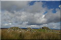
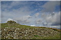
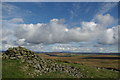
markj99 visited on 9th Feb 2022 Cairnerzean Fell Central Cairn is one of the Cairnerzean Fell Cairn Group on open moorland. The cairns vary in states of preservation from entirely robbed out to relatively intact. Cairnerzean Fell Central Cairn has been extensively robbed leaving a c. 4 feet high crescent of stones in the NE Arc of the original cairn. The remainder of the cairn has disappeared into a circle of boggy moorland.
")
Cairnerzean Fell Central Cairn is a ruined cairn located c. 250 yards S of Cairnerzean Fell N Cairn. It is the central cairn of a group of three cairns on Cairnerzean Fell. Only a narrow crescent of the NE Arc survives up to a height of c. 4 feet. The robbed-out interior of the cairn is a stone-free marshy circle. The original diameter of the cairn would have been c. 20 yards. Canmore ID 61497 has a full description of the cairn.
Directions: Take the A77 S from Ayr to Cairnryan. Drive 2.5 miles S from the 30mph speed limit on the S of Cairnryan. There is an unsigned left turn into a single track road to New Luce in the middle of a long straight at NX 0859 6374. Travel on this narrow road for c. 3.5 miles to a parking place beside an old WWII bombing target at NX 1142 6753. Cairnerzean Fell lies c. 2.5 miles E of here. My walking route is viewable on Cairnerzean Cairns Route. Good walking boots, a GPS device and good stamina are requirements for this 5 mile walk over pathless open moorland.
You may be viewing yesterday's version of this page. To see the most up to date information please register for a free account.
")
")
")
")
Do not use the above information on other web sites or publications without permission of the contributor.
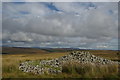
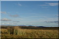
Nearby Images from Geograph Britain and Ireland:
©2012(licence)
©2012(licence)
©2012(licence)
©2012(licence)
©2012(licence)
The above images may not be of the site on this page, they are loaded from Geograph.
Please Submit an Image of this site or go out and take one for us!
Click here to see more info for this site
Nearby sites
Key: Red: member's photo, Blue: 3rd party photo, Yellow: other image, Green: no photo - please go there and take one, Grey: site destroyed
Download sites to:
KML (Google Earth)
GPX (GPS waypoints)
CSV (Garmin/Navman)
CSV (Excel)
To unlock full downloads you need to sign up as a Contributory Member. Otherwise downloads are limited to 50 sites.
Turn off the page maps and other distractions
Nearby sites listing. In the following links * = Image available
222m N 350° Cairnerzean Fell N* Cairn (NX13836642)
353m SW 223° Cairnerzean Fell South* Cairn (NX13616595)
545m NNW 329° Cairnerzean Fell Summit* Cairn (NX13606668)
620m ENE 60° Lingdowey Burn N* Cairn (NX14416649)
762m ENE 76° Lingdowey Burn S* Cairn (NX14616635)
1.2km NE 48° Lingdowey Burn E* Cairn (NX14806698)
1.3km SSW 193° Auld Wife's Grave* Chambered Cairn (NX13536498)
1.7km NE 39° Cairnerzean Farm SW* Cairn (NX14986747)
1.7km NE 39° Cairnerzean Farm NE* Cairn (NX14996748)
2.6km ESE 109° Gowk Nest Wood* Cairn (NX16306523)
2.6km SSE 163° Auchmantle Fell (The Muckle Cairn)* Cairn (NX14546365)
2.7km SSE 164° Auchmantle Fell (The Wee Cairn)* Cairn (NX14526353)
2.8km ESE 115° Mains of Larg NW* Cairn (NX16356493)
2.8km ESE 114° Mains of Larg NE* Cairn (NX16406497)
2.9km NE 35° Kilfeddar Farm* Cairn (NX15626852)
2.9km NW 310° Drumacissock South Cairn* Cairn (NX11676818)
3.0km NW 311° Drumacissock North Cairn* Cairn (NX11706827)
3.1km NE 48° Altigoukie Burn Cairn* Cairn (NX16266817)
3.1km NNW 330° Diddles Hill Cairn* Cairn (NX12446896)
3.1km NE 50° Altigoukie Burn Burnt Mound* Misc. Earthwork (NX16336811)
3.2km ENE 75° Barlure* Cairn (NX17036693)
3.5km WSW 240° Balker Moor N* Cairn (NX10726455)
3.6km WSW 238° Balker Moor S* Cairn (NX10766444)
3.6km SE 128° Mains of Larg cairn* Cairn (NX16616385)
3.7km SSE 168° Glenterrow Cairn* Cairn (NX14506256)
View more nearby sites and additional images


 We would like to know more about this location. Please feel free to add a brief description and any relevant information in your own language.
 Wir möchten mehr über diese Stätte erfahren. Bitte zögern Sie nicht, eine kurze Beschreibung und relevante Informationen in Deutsch hinzuzufügen.
 Nous aimerions en savoir encore un peu sur les lieux. S'il vous plaît n'hesitez pas à ajouter une courte description et tous les renseignements pertinents dans votre propre langue.
 Quisieramos informarnos un poco más de las lugares. No dude en añadir una breve descripción y otros datos relevantes en su propio idioma.