<< Our Photo Pages >> Foel y Mwnt - Promontory Fort / Cliff Castle in Wales in Ceredigion
Submitted by Antonine on Sunday, 22 May 2022 Page Views: 1095
Iron Age and Later PrehistorySite Name: Foel y MwntCountry: Wales
NOTE: This site is 14.3 km away from the location you searched for.
County: Ceredigion Type: Promontory Fort / Cliff Castle
Nearest Village: Mwnt
Map Ref: SN193520
Latitude: 52.136668N Longitude: 4.641787W
Condition:
| 5 | Perfect |
| 4 | Almost Perfect |
| 3 | Reasonable but with some damage |
| 2 | Ruined but still recognisable as an ancient site |
| 1 | Pretty much destroyed, possibly visible as crop marks |
| 0 | No data. |
| -1 | Completely destroyed |
| 5 | Superb |
| 4 | Good |
| 3 | Ordinary |
| 2 | Not Good |
| 1 | Awful |
| 0 | No data. |
| 5 | Can be driven to, probably with disabled access |
| 4 | Short walk on a footpath |
| 3 | Requiring a bit more of a walk |
| 2 | A long walk |
| 1 | In the middle of nowhere, a nightmare to find |
| 0 | No data. |
| 5 | co-ordinates taken by GPS or official recorded co-ordinates |
| 4 | co-ordinates scaled from a detailed map |
| 3 | co-ordinates scaled from a bad map |
| 2 | co-ordinates of the nearest village |
| 1 | co-ordinates of the nearest town |
| 0 | no data |
Be the first person to rate this site - see the 'Contribute!' box in the right hand menu.
Internal Links:
External Links:
")
For more information see: pdf document and Coflein ID 403286.
You may be viewing yesterday's version of this page. To see the most up to date information please register for a free account.
")
")
")
")
Do not use the above information on other web sites or publications without permission of the contributor.
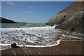
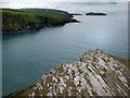
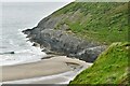
Nearby Images from Geograph Britain and Ireland:

©2016(licence)

©2007(licence)
©2008(licence)
©2007(licence)
©2021(licence)
The above images may not be of the site on this page, they are loaded from Geograph.
Please Submit an Image of this site or go out and take one for us!
Click here to see more info for this site
Nearby sites
Key: Red: member's photo, Blue: 3rd party photo, Yellow: other image, Green: no photo - please go there and take one, Grey: site destroyed
Download sites to:
KML (Google Earth)
GPX (GPS waypoints)
CSV (Garmin/Navman)
CSV (Excel)
To unlock full downloads you need to sign up as a Contributory Member. Otherwise downloads are limited to 50 sites.
Turn off the page maps and other distractions
Nearby sites listing. In the following links * = Image available
1.8km SW 234° Crug Farm Tumulus Round Barrow(s) (SN178510)
3.3km SW 215° Towyn Warren Ancient Village or Settlement (SN17294932)
4.2km SE 145° Llech Yr Ast Standing Stone (Menhir) (SN216485)
4.6km SSE 164° Banc-y-Warren Hillfort (SN20414750)
5.7km SSE 156° Pant y Butler round barrows* Round Barrow(s) (SN21464672)
5.7km SW 224° Manian Fach Tumulus Round Barrow(s) (SN152480)
6.3km SSW 192° Cardigan Eisteddfod Commemorative Stone Modern Stone Circle etc (SN1774645894)
6.5km SSW 204° Blessingstone* Natural Stone / Erratic / Other Natural Feature (SN164462)
6.7km SSW 203° St Dogmael's Church* Early Christian Sculptured Stone (SN1640745909)
7.2km SW 232° Cippyn Burnt Mounds Artificial Mound (SN134478)
8.9km S 179° Cilgerran Churchyard* Standing Stone (Menhir) (SN19074306)
9.3km S 177° Cilgerran stone* Standing Stone (Menhir) (SN1945942671)
9.6km E 92° Corbalengi Stone* Sculptured Stone (SN2890151375)
10.0km S 188° Bridell Churchyard* Standing Stone (Menhir) (SN176421)
10.2km ESE 103° Caer Pwntan Hillfort (SN29164933)
10.6km E 97° Castell Nadolig Hillfort (SN29855040)
10.8km E 86° Gaer Lwyd Hillfort (SN30145240)
11.1km E 82° Garreg Standing Stones Standing Stones (SN304531)
11.3km SE 126° Pant-Llech-Clawdd Burnt Mound Artificial Mound (SN28264505)
11.5km SSW 194° Y Gaer (Pembrokeshire) Hillfort (SN16024097)
11.8km SW 218° Trefaes Ganol Standing Stone Standing Stone (Menhir) (SN1167042952)
12.5km SSW 211° Crugiau Cemaes* Barrow Cemetery (SN125415)
12.6km ENE 75° Pendinas Lochtyn* Hillfort (SN31565486)
12.6km S 191° Parc y Mean Llwyd Standing Stone (Menhir) (SN164397)
12.6km ENE 72° Ynys Lochtyn* Ancient Village or Settlement (SN31475552)
View more nearby sites and additional images


 We would like to know more about this location. Please feel free to add a brief description and any relevant information in your own language.
 Wir möchten mehr über diese Stätte erfahren. Bitte zögern Sie nicht, eine kurze Beschreibung und relevante Informationen in Deutsch hinzuzufügen.
 Nous aimerions en savoir encore un peu sur les lieux. S'il vous plaît n'hesitez pas à ajouter une courte description et tous les renseignements pertinents dans votre propre langue.
 Quisieramos informarnos un poco más de las lugares. No dude en añadir una breve descripción y otros datos relevantes en su propio idioma.