

<< Text Pages >> Foel Feddau - Cairn in Wales in Pembrokeshire
Submitted by vicky on Sunday, 29 September 2002 Page Views: 7245
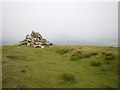
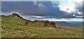
Neolithic and Bronze AgeSite Name: Foel Feddau Alternative Name: Moel Feddau, NevernCountry: Wales County: Pembrokeshire Type: Cairn
Nearest Town: Newport Nearest Village: Mynachlog-Ddu
Map Ref: SN102324 Landranger Map Number: 145
Latitude: 51.957606N Longitude: 4.763703W
Condition:
| 5 | Perfect |
| 4 | Almost Perfect |
| 3 | Reasonable but with some damage |
| 2 | Ruined but still recognisable as an ancient site |
| 1 | Pretty much destroyed, possibly visible as crop marks |
| 0 | No data. |
| -1 | Completely destroyed |
| 5 | Superb |
| 4 | Good |
| 3 | Ordinary |
| 2 | Not Good |
| 1 | Awful |
| 0 | No data. |
| 5 | Can be driven to, probably with disabled access |
| 4 | Short walk on a footpath |
| 3 | Requiring a bit more of a walk |
| 2 | A long walk |
| 1 | In the middle of nowhere, a nightmare to find |
| 0 | No data. |
| 5 | co-ordinates taken by GPS or official recorded co-ordinates |
| 4 | co-ordinates scaled from a detailed map |
| 3 | co-ordinates scaled from a bad map |
| 2 | co-ordinates of the nearest village |
| 1 | co-ordinates of the nearest town |
| 0 | no data |
Internal Links:
External Links:
Hilltop Cairn in Pembrokeshire
Have you visited this site? Please add a comment below.
You may be viewing yesterday's version of this page. To see the most up to date information please register for a free account.
")
Do not use the above information on other web sites or publications without permission of the contributor.
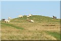
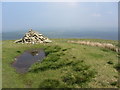
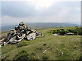
Nearby Images from Geograph Britain and Ireland:
©2005(licence)
©2016(licence)
©2016(licence)
©2011(licence)
©2014(licence)
The above images may not be of the site on this page, they are loaded from Geograph.
Please Submit an Image of this site or go out and take one for us!
Click here to see more info for this site
Nearby sites
Key: Red: member's photo, Blue: 3rd party photo, Yellow: other image, Green: no photo - please go there and take one, Grey: site destroyed
Download sites to:
KML (Google Earth)
GPX (GPS waypoints)
CSV (Garmin/Navman)
CSV (Excel)
To unlock full downloads you need to sign up as a Contributory Member. Otherwise downloads are limited to 50 sites.
Turn off the page maps and other distractions
Nearby sites listing. In the following links * = Image available
665m E 101° Cerrigmarchogion* Rock Outcrop (SN10853225)
1.1km NW 306° Banc Llwydlos* Ancient Village or Settlement (SN093331)
1.2km SSE 153° Waun Clyn Coch Ancient Village or Settlement (SN107313)
1.4km SSW 211° Foel Cwmcerwyn* Cairn (SN094312)
2.1km SE 128° Cwm Garw* Standing Stones (SN11823102)
2.3km NNE 13° Bedd yr Afanc* Passage Grave (SN10793458)
2.3km SSE 153° Gate Standing Stone* Standing Stone (Menhir) (SN11143033)
2.3km SE 144° Glynsaithmaen* Standing Stones (SN115305)
2.4km SW 214° Cnwc Barrow 1 Round Barrow(s) (SN088305)
2.4km SSE 154° Glynsaithmaen SW* Standing Stone (Menhir) (SN11173021)
2.4km WNW 300° Tafarn-y-Bwlch* Standing Stones (SN08133370)
2.5km NW 310° Waun Mawn NE* Standing Stones (SN08353405)
2.6km WSW 240° Mynydd Du* Cairn (SN079312)
2.6km SW 215° Cnwc Barrow 2 Round Barrow(s) (SN086303)
2.7km WNW 303° Waun Mawn W* Standing Stone (Menhir) (SN08033394)
2.7km E 88° Carn Bica* Cairn (SN129324)
2.8km ESE 106° Carn Sian - unknown* Cairn (SN1282431539)
2.8km ENE 69° Carngoedog* Ancient Mine, Quarry or other Industry (SN1283133283)
2.8km ESE 106° Carn Sian Linear feature* Stone Row / Alignment (SN1286831525)
2.8km E 86° Bedd Arthur* Stone Circle (SN13053251)
2.9km NNE 18° Brynberian Round Barrow(s) (SN112351)
2.9km ESE 107° Carn Sian Cairn* Not Known (by us) (SN1294231474)
2.9km SSW 200° Mynydd Crwn Standing Stone Standing Stone (Menhir) (SN091297)
3.2km E 91° Carn Arthur* Natural Stone / Erratic / Other Natural Feature (SN1337532232)
3.3km NNW 337° The Penlan Stone* Standing Stone (Menhir) (SN09053545)
View more nearby sites and additional images


 We would like to know more about this location. Please feel free to add a brief description and any relevant information in your own language.
 Wir möchten mehr über diese Stätte erfahren. Bitte zögern Sie nicht, eine kurze Beschreibung und relevante Informationen in Deutsch hinzuzufügen.
 Nous aimerions en savoir encore un peu sur les lieux. S'il vous plaît n'hesitez pas à ajouter une courte description et tous les renseignements pertinents dans votre propre langue.
 Quisieramos informarnos un poco más de las lugares. No dude en añadir una breve descripción y otros datos relevantes en su propio idioma.