

<< Other Photo Pages >> An Dun (Loch Ardbhair) - Broch or Nuraghe in Scotland in Sutherland
Submitted by Andy B on Sunday, 18 April 2010 Page Views: 8009
Iron Age and Later PrehistorySite Name: An Dun (Loch Ardbhair)Country: Scotland
NOTE: This site is 6.9 km away from the location you searched for.
County: Sutherland Type: Broch or Nuraghe
Map Ref: NC16893324
Latitude: 58.249645N Longitude: 5.121857W
Condition:
| 5 | Perfect |
| 4 | Almost Perfect |
| 3 | Reasonable but with some damage |
| 2 | Ruined but still recognisable as an ancient site |
| 1 | Pretty much destroyed, possibly visible as crop marks |
| 0 | No data. |
| -1 | Completely destroyed |
| 5 | Superb |
| 4 | Good |
| 3 | Ordinary |
| 2 | Not Good |
| 1 | Awful |
| 0 | No data. |
| 5 | Can be driven to, probably with disabled access |
| 4 | Short walk on a footpath |
| 3 | Requiring a bit more of a walk |
| 2 | A long walk |
| 1 | In the middle of nowhere, a nightmare to find |
| 0 | No data. |
| 5 | co-ordinates taken by GPS or official recorded co-ordinates |
| 4 | co-ordinates scaled from a detailed map |
| 3 | co-ordinates scaled from a bad map |
| 2 | co-ordinates of the nearest village |
| 1 | co-ordinates of the nearest town |
| 0 | no data |
Internal Links:
External Links:
I have visited· I would like to visit
Andy B has visited here
 (PID:55999)")
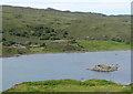
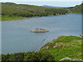
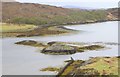
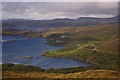
An Dun broch, Loch Ardbhair, is best visited at Low Tide. It is connected to the mainland by an interesting dry stane dyke. The original access to the inside of the broch faces south. The shallow waters are teeming with mussels. Lovely spot.
You may be viewing yesterday's version of this page. To see the most up to date information please register for a free account.
 (PID:56026)")
Do not use the above information on other web sites or publications without permission of the contributor.
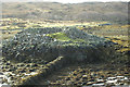
Nearby Images from Geograph Britain and Ireland:
©2009(licence)
©2009(licence)
©2009(licence)
©2018(licence)
©2007(licence)
The above images may not be of the site on this page, they are loaded from Geograph.
Please Submit an Image of this site or go out and take one for us!
Click here to see more info for this site
Nearby sites
Key: Red: member's photo, Blue: 3rd party photo, Yellow: other image, Green: no photo - please go there and take one, Grey: site destroyed
Download sites to:
KML (Google Earth)
GPX (GPS waypoints)
CSV (Garmin/Navman)
CSV (Excel)
To unlock full downloads you need to sign up as a Contributory Member. Otherwise downloads are limited to 50 sites.
Turn off the page maps and other distractions
Nearby sites listing. In the following links * = Image available
4.9km ENE 77° Kylestrome Broch* Broch or Nuraghe (NC217341)
8.3km S 183° Loch Assynt Crannog (NC1603225018)
9.7km N 356° Cnoc An Daimh* Chambered Cairn (NC1667342937)
10.1km SE 137° Allt Sgiathaig* Chambered Cairn (NC23412552)
11.9km SE 140° Ardvreck* Chambered Cairn (NC24142371)
13.5km WSW 257° Loch Na Claise Crannog (NC03543082)
14.2km WSW 245° Clachtoll Stone Circle* Stone Circle (NC037278)
14.2km WSW 245° Clachtoll Broch* Broch or Nuraghe (NC03652785)
14.4km NNE 17° Badnabay* Chambered Cairn (NC218468)
14.7km SE 139° Carrachan Dubh Chambered Cairn (NC26102176)
19.0km SE 146° Allt nan Uamh Bone Caves* Cave or Rock Shelter (NC268170)
20.5km SSW 207° Inverpolly Stone Fort or Dun (NC06611551)
20.7km SSE 155° Ledbeg River* Chambered Cairn (NC24891411)
21.1km SSE 159° Cam Loch B Chambered Cairn (NC23431314)
21.1km SSE 159° Cam Loch A Cairn (NC23501312)
21.9km SSE 163° Glacbain* Cairn (NC2231112011)
22.2km SSE 159° Ledmore* Chambered Cairn (NC23821215)
23.5km SSE 155° Loch Borralan Crannog* Crannog (NC25741138)
23.9km SSE 155° Loch Borralan West* Chambered Cairn (NC2603811142)
23.9km SSE 154° Loch Borralan East* Chambered Cairn (NC26241118)
24.2km SSE 154° Altnacealgach* Chambered Cairn (NC2652811033)
24.6km SW 215° Brae of Achnahaird Stone Fort or Dun (NC01701380)
28.0km SSE 150° Cnoc Chaornaidh North West* Chambered Cairn (NC299084)
28.3km SSE 149° Cnoc Chaornaidh Central* Cairn (NC30170818)
28.6km SSE 149° Cnoc Chaornaidh South-east* Chambered Cairn (NC30320793)
View more nearby sites and additional images


 We would like to know more about this location. Please feel free to add a brief description and any relevant information in your own language.
 Wir möchten mehr über diese Stätte erfahren. Bitte zögern Sie nicht, eine kurze Beschreibung und relevante Informationen in Deutsch hinzuzufügen.
 Nous aimerions en savoir encore un peu sur les lieux. S'il vous plaît n'hesitez pas à ajouter une courte description et tous les renseignements pertinents dans votre propre langue.
 Quisieramos informarnos un poco más de las lugares. No dude en añadir una breve descripción y otros datos relevantes en su propio idioma.