<< Our Photo Pages >> Mynydd Carn Ingli - Standing Stone (Menhir) in Wales in Pembrokeshire
Submitted by vicky on Wednesday, 05 November 2003 Page Views: 10782
Neolithic and Bronze AgeSite Name: Mynydd Carn Ingli Alternative Name: Crn LlwydCountry: Wales County: Pembrokeshire Type: Standing Stone (Menhir)
Map Ref: SN063376 Landranger Map Number: 145
Latitude: 52.002955N Longitude: 4.823326W
Condition:
| 5 | Perfect |
| 4 | Almost Perfect |
| 3 | Reasonable but with some damage |
| 2 | Ruined but still recognisable as an ancient site |
| 1 | Pretty much destroyed, possibly visible as crop marks |
| 0 | No data. |
| -1 | Completely destroyed |
| 5 | Superb |
| 4 | Good |
| 3 | Ordinary |
| 2 | Not Good |
| 1 | Awful |
| 0 | No data. |
| 5 | Can be driven to, probably with disabled access |
| 4 | Short walk on a footpath |
| 3 | Requiring a bit more of a walk |
| 2 | A long walk |
| 1 | In the middle of nowhere, a nightmare to find |
| 0 | No data. |
| 5 | co-ordinates taken by GPS or official recorded co-ordinates |
| 4 | co-ordinates scaled from a detailed map |
| 3 | co-ordinates scaled from a bad map |
| 2 | co-ordinates of the nearest village |
| 1 | co-ordinates of the nearest town |
| 0 | no data |
Internal Links:
External Links:
I have visited· I would like to visit
Penbron has visited here
")
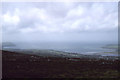
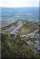
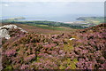
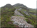
This small standing stone lies on the northern slopes of Carn Ingli Mountain close to the footpath and in amongst several hut circles and an earthwork. It as fantastic views out across Cardigan Bay.
You may be viewing yesterday's version of this page. To see the most up to date information please register for a free account.
")
Do not use the above information on other web sites or publications without permission of the contributor.
Nearby Images from Geograph Britain and Ireland:
©2013(licence)

©2007(licence)
©2005(licence)
©2011(licence)
©2016(licence)
The above images may not be of the site on this page, they are loaded from Geograph.
Please Submit an Image of this site or go out and take one for us!
Click here to see more info for this site
Nearby sites
Key: Red: member's photo, Blue: 3rd party photo, Yellow: other image, Green: no photo - please go there and take one, Grey: site destroyed
Download sites to:
KML (Google Earth)
GPX (GPS waypoints)
CSV (Garmin/Navman)
CSV (Excel)
To unlock full downloads you need to sign up as a Contributory Member. Otherwise downloads are limited to 50 sites.
Turn off the page maps and other distractions
Nearby sites listing. In the following links * = Image available
nankm 0° Carn Ingli Barrows Round Barrow(s) (SN063376)
200m N 358° Carn Ingli Mountain Neolithic Settlement Ancient Village or Settlement (SN063378)
200m N 358° Carn Ingli Settlement Hillfort (SN063378)
281m NW 322° Crn Llwyd Stone* Standing Stone (Menhir) (SN0613537828)
341m S 182° Carn Ingli Mountain Fort* Hillfort (SN0627737260)
592m S 186° Carn Ingli Settlement South Ancient Village or Settlement (SN0621237014)
609m N 351° Carn Llwyd Open Settlement Ancient Village or Settlement (SN0623038205)
850m SW 229° Carn Briw* Cairn (SN0563537067)
852m ENE 67° Brithdir Mawr stone circle* Modern Stone Circle etc (SN071379)
1.0km SSW 207° Dol-Rhang-Isaf Cairn Cairn (SN05783669)
1.1km WSW 246° Carn Ingli Mountain IA Settlement Ancient Village or Settlement (SN053372)
1.1km SW 223° Carn Edward Ancient Village or Settlement (SN055368)
1.1km SW 230° Carn Llwyd* Ancient Village or Settlement (SN054369)
1.3km ENE 71° Brithdir Mawr Barrow* Modern Stone Circle etc (SN0753137967)
1.3km SW 226° Carn Ingli Kerb Cairn Cairn (SN053367)
1.4km NNW 337° Inscribed cross stones St. Mary's church* Early Christian Sculptured Stone (SN058389)
1.4km W 264° Waun Fawr Ancient Village or Settlement (SN049375)
1.5km W 279° Carn Ffoi* Hillfort (SN048379)
1.6km NNW 339° Golden Lion stone* Standing Stone (Menhir) (SN058391)
1.8km N 349° Carreg Coetan Arthur* Burial Chamber or Dolmen (SN06033935)
2.1km SW 229° Gochel Sythi Standing Stone (Menhir) (SN047363)
2.1km SSE 161° Trefach Enclosure Hillfort (SN06923555)
2.4km WSW 240° Mynydd Caregog Ancient Village or Settlement (SN042365)
2.5km S 175° Trefach* Standing Stone (Menhir) (SN064351)
2.7km WSW 244° Bedd Morris* Standing Stone (Menhir) (SN0381836502)
View more nearby sites and additional images


 We would like to know more about this location. Please feel free to add a brief description and any relevant information in your own language.
 Wir möchten mehr über diese Stätte erfahren. Bitte zögern Sie nicht, eine kurze Beschreibung und relevante Informationen in Deutsch hinzuzufügen.
 Nous aimerions en savoir encore un peu sur les lieux. S'il vous plaît n'hesitez pas à ajouter une courte description et tous les renseignements pertinents dans votre propre langue.
 Quisieramos informarnos un poco más de las lugares. No dude en añadir una breve descripción y otros datos relevantes en su propio idioma.