 with our Megalithic Portal iPhone app")
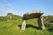

<< Our Photo Pages >> Little Dennis - Promontory Fort / Cliff Castle in England in Cornwall
Submitted by SolarMegalith on Saturday, 04 June 2011 Page Views: 5476
Iron Age and Later PrehistorySite Name: Little DennisCountry: England
NOTE: This site is 0.7 km away from the location you searched for.
County: Cornwall Type: Promontory Fort / Cliff Castle
Nearest Village: St Anthony-in-Meneage
Map Ref: SW7864425648
Latitude: 50.089608N Longitude: 5.095944W
Condition:
| 5 | Perfect |
| 4 | Almost Perfect |
| 3 | Reasonable but with some damage |
| 2 | Ruined but still recognisable as an ancient site |
| 1 | Pretty much destroyed, possibly visible as crop marks |
| 0 | No data. |
| -1 | Completely destroyed |
| 5 | Superb |
| 4 | Good |
| 3 | Ordinary |
| 2 | Not Good |
| 1 | Awful |
| 0 | No data. |
| 5 | Can be driven to, probably with disabled access |
| 4 | Short walk on a footpath |
| 3 | Requiring a bit more of a walk |
| 2 | A long walk |
| 1 | In the middle of nowhere, a nightmare to find |
| 0 | No data. |
| 5 | co-ordinates taken by GPS or official recorded co-ordinates |
| 4 | co-ordinates scaled from a detailed map |
| 3 | co-ordinates scaled from a bad map |
| 2 | co-ordinates of the nearest village |
| 1 | co-ordinates of the nearest town |
| 0 | no data |
Internal Links:
External Links:
")
Read more at Pastscape.
You may be viewing yesterday's version of this page. To see the most up to date information please register for a free account.
")
")
")
Do not use the above information on other web sites or publications without permission of the contributor.
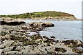
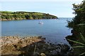
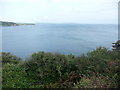
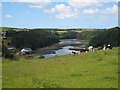
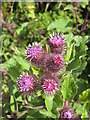
Nearby Images from Geograph Britain and Ireland:
©2017(licence)
©2017(licence)
©2010(licence)
©2008(licence)
©2008(licence)
The above images may not be of the site on this page, they are loaded from Geograph.
Please Submit an Image of this site or go out and take one for us!
Click here to see more info for this site
Nearby sites
Key: Red: member's photo, Blue: 3rd party photo, Yellow: other image, Green: no photo - please go there and take one, Grey: site destroyed
Download sites to:
KML (Google Earth)
GPX (GPS waypoints)
CSV (Garmin/Navman)
CSV (Excel)
To unlock full downloads you need to sign up as a Contributory Member. Otherwise downloads are limited to 50 sites.
Turn off the page maps and other distractions
Nearby sites listing. In the following links * = Image available
347m W 276° St Anthony's Well (St Anthony-in-Meneag)* Holy Well or Sacred Spring (SW783257)
445m W 261° St Anthony in Meneage Cross* Ancient Cross (SW782256)
1.7km N 359° St Mawnan's Well* Holy Well or Sacred Spring (SW7868527385)
2.4km SW 228° Boden Fogou* Souterrain (Fogou, Earth House) (SW768241)
2.5km WSW 250° Manaccan Well* Holy Well or Sacred Spring (SW763249)
2.5km NNE 22° Rosemullion Head* Promontory Fort / Cliff Castle (SW79682788)
2.6km SSW 193° Roskruge Beacon* Round Barrow(s) (SW7796623106)
4.6km SSE 154° Giant's Quoits* Rock Outcrop (SW80452145)
4.7km S 188° Tremenhere Menhir* Standing Stone (Menhir) (SW778210)
5.8km S 189° Crousa Common* Standing Stones (SW775200)
5.9km S 190° St Keverne Beacon Tumulus* Chambered Cairn (SW77361987)
5.9km WSW 257° Caervallack Holy Well Holy Well or Sacred Spring (SW7279724512)
6.1km WSW 257° Caervallack Fort* Hillfort (SW7261624555)
6.2km S 189° Little Kistles Kerb Cairn* Cairn (SW77411959)
6.3km SSE 163° Lowland Point* Ancient Village or Settlement (SW80251952)
6.4km WNW 300° Tolmen Stone (Constantine) Burial Chamber or Dolmen (SW7326429059)
6.4km SSW 201° Three Brothers of Grugith* Burial Chamber or Dolmen (SW76161978)
6.6km W 260° Gear Round (Helston)* Hillfort (SW7209324805)
6.6km S 188° Crousa Downs Settlement* Ancient Village or Settlement (SW77401916)
6.6km SSW 193° Tide Rock* Rock Outcrop (SW76921923)
6.6km SW 224° Traboe Barrow Cemetery* Barrow Cemetery (SW7378321099)
6.7km NNW 327° Helland House Ancient Cornish Cross* Ancient Cross (SW752314)
6.7km N 357° Budock Church Crosses* Ancient Cross (SW78603239)
6.9km NW 322° Eathorne Menhir* Standing Stone (Menhir) (SW746313)
7.3km NNW 330° Lower Spargo* Standing Stone (Menhir) (SW753321)
View more nearby sites and additional images


 We would like to know more about this location. Please feel free to add a brief description and any relevant information in your own language.
 Wir möchten mehr über diese Stätte erfahren. Bitte zögern Sie nicht, eine kurze Beschreibung und relevante Informationen in Deutsch hinzuzufügen.
 Nous aimerions en savoir encore un peu sur les lieux. S'il vous plaît n'hesitez pas à ajouter une courte description et tous les renseignements pertinents dans votre propre langue.
 Quisieramos informarnos un poco más de las lugares. No dude en añadir una breve descripción y otros datos relevantes en su propio idioma.