<< Our Photo Pages >> Maen Dewi - Standing Stone (Menhir) in Wales in Pembrokeshire
Submitted by vicky on Friday, 25 April 2003 Page Views: 7469
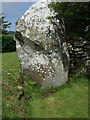
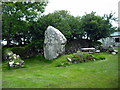
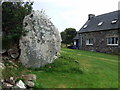
Neolithic and Bronze AgeSite Name: Maen DewiCountry: Wales County: Pembrokeshire Type: Standing Stone (Menhir)
Nearest Village: Caerfarchell
Map Ref: SM775275 Landranger Map Number: 157
Latitude: 51.901498N Longitude: 5.23568W
Condition:
| 5 | Perfect |
| 4 | Almost Perfect |
| 3 | Reasonable but with some damage |
| 2 | Ruined but still recognisable as an ancient site |
| 1 | Pretty much destroyed, possibly visible as crop marks |
| 0 | No data. |
| -1 | Completely destroyed |
| 5 | Superb |
| 4 | Good |
| 3 | Ordinary |
| 2 | Not Good |
| 1 | Awful |
| 0 | No data. |
| 5 | Can be driven to, probably with disabled access |
| 4 | Short walk on a footpath |
| 3 | Requiring a bit more of a walk |
| 2 | A long walk |
| 1 | In the middle of nowhere, a nightmare to find |
| 0 | No data. |
| 5 | co-ordinates taken by GPS or official recorded co-ordinates |
| 4 | co-ordinates scaled from a detailed map |
| 3 | co-ordinates scaled from a bad map |
| 2 | co-ordinates of the nearest village |
| 1 | co-ordinates of the nearest town |
| 0 | no data |
Internal Links:
External Links:
I have visited· I would like to visit
Penbron has visited here
")
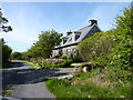
This is a large a stone located in the back gardens of two cottages. Please seek permission before viewing (as we did).
You may be viewing yesterday's version of this page. To see the most up to date information please register for a free account.
")
Do not use the above information on other web sites or publications without permission of the contributor.
Nearby Images from Geograph Britain and Ireland:
©2009(licence)
©2009(licence)

©2007(licence)
©2019(licence)
©2007(licence)
The above images may not be of the site on this page, they are loaded from Geograph.
Please Submit an Image of this site or go out and take one for us!
Click here to see more info for this site
Nearby sites
Key: Red: member's photo, Blue: 3rd party photo, Yellow: other image, Green: no photo - please go there and take one, Grey: site destroyed
Download sites to:
KML (Google Earth)
GPX (GPS waypoints)
CSV (Garmin/Navman)
CSV (Excel)
To unlock full downloads you need to sign up as a Contributory Member. Otherwise downloads are limited to 50 sites.
Turn off the page maps and other distractions
Nearby sites listing. In the following links * = Image available
1.9km SSW 203° Trecenny Stone* Standing Stone (Menhir) (SM7665725755)
2.4km WSW 241° Trefarchan* Standing Stone (Menhir) (SM7531126407)
2.8km SSE 153° Nine Wells Cromlech Standing Stone (Menhir) (SM7865624977)
2.9km SSE 150° Nine Wells Standing Stone 1 Standing Stone (Menhir) (SM7883524931)
2.9km SW 218° Cocyn Round* Misc. Earthwork (SM7559325258)
2.9km SW 225° Ffynnon-Y-Cwcwll Holy Well or Sacred Spring (SM7533725498)
3.0km SE 142° Llanungar-Fawr Standing Stone Standing Stone (Menhir) (SM7922025093)
3.0km SSE 148° Nine Wells Standing Stone 2 Standing Stone (Menhir) (SM7894824912)
3.0km SSE 149° Nine Wells Standing Stone 3 Standing Stone (Menhir) (SM7890524883)
3.0km SW 217° Pembrokeshire National Park Visitors Centre* Museum (SM756252)
3.0km SSE 149° Nine Wells possible Standing Stone 4 Standing Stone (Menhir) (SM7895824821)
3.1km SW 224° St David's Cathedral* Ancient Cross (SM75202536)
3.5km SSE 158° Porth-y-Rhaw* Promontory Fort / Cliff Castle (SM787242)
3.6km SSW 198° Penpleidiau fort* Hillfort (SM762241)
3.7km E 94° Lecha Dolmen Chambered Tomb (SM81152711)
3.7km W 263° Ffynnon Faiddog Holy Well or Sacred Spring (SM73842720)
3.9km SE 140° St Aidan's Church (Solva) Early Christian Sculptured Stone (SM799244)
3.9km SW 215° St Non's Well (Pembrokeshire)* Holy Well or Sacred Spring (SM75102437)
4.0km SW 215° St Non's Chapel* Early Christian Sculptured Stone (SM7507524345)
4.0km W 273° Carn Llidi* Chambered Tomb (SM73512790)
4.3km E 89° Llanhowel Church* Early Christian Sculptured Stone (SM818274)
4.3km W 262° Whitesands Bay Submerged Forest Not Known (by us) (SM7320227125)
4.4km NNE 22° Abereiddy Promontory Fort* Promontory Fort / Cliff Castle (SM79373150)
4.5km SW 235° Clegyr Boia* Hillfort (SM73732509)
4.5km SE 141° Solva Gribin Fort* Promontory Fort / Cliff Castle (SM80212390)
View more nearby sites and additional images


 We would like to know more about this location. Please feel free to add a brief description and any relevant information in your own language.
 Wir möchten mehr über diese Stätte erfahren. Bitte zögern Sie nicht, eine kurze Beschreibung und relevante Informationen in Deutsch hinzuzufügen.
 Nous aimerions en savoir encore un peu sur les lieux. S'il vous plaît n'hesitez pas à ajouter une courte description et tous les renseignements pertinents dans votre propre langue.
 Quisieramos informarnos un poco más de las lugares. No dude en añadir una breve descripción y otros datos relevantes en su propio idioma.