 with our Megalithic Portal iPhone app")

, Aubrey Burl")
<< Our Photo Pages >> Dun Acardinon - Stone Fort or Dun in Scotland in Isle of Skye
Submitted by Andy B on Tuesday, 19 October 2010 Page Views: 3210
Multi-periodSite Name: Dun AcardinonCountry: Scotland County: Isle of Skye Type: Stone Fort or Dun
Nearest Town: Mallaig Nearest Village: Ardvaser
Map Ref: NG63250305
Latitude: 57.057482N Longitude: 5.906027W
Condition:
| 5 | Perfect |
| 4 | Almost Perfect |
| 3 | Reasonable but with some damage |
| 2 | Ruined but still recognisable as an ancient site |
| 1 | Pretty much destroyed, possibly visible as crop marks |
| 0 | No data. |
| -1 | Completely destroyed |
| 5 | Superb |
| 4 | Good |
| 3 | Ordinary |
| 2 | Not Good |
| 1 | Awful |
| 0 | No data. |
| 5 | Can be driven to, probably with disabled access |
| 4 | Short walk on a footpath |
| 3 | Requiring a bit more of a walk |
| 2 | A long walk |
| 1 | In the middle of nowhere, a nightmare to find |
| 0 | No data. |
| 5 | co-ordinates taken by GPS or official recorded co-ordinates |
| 4 | co-ordinates scaled from a detailed map |
| 3 | co-ordinates scaled from a bad map |
| 2 | co-ordinates of the nearest village |
| 1 | co-ordinates of the nearest town |
| 0 | no data |
Internal Links:
External Links:
")
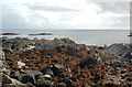
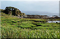
On the S side of the small bay lying immediately to the S of Rudha Dubh, is a rocky plateau standing some 25-35ft above the sea, and connected with the land on the W side by a narrow neck. It is of very irregular outline, being almost split in two by a deep gully running in from the seaward side.
Known usually as Carn Breac, but sometimes as Dun Acardinon, its defensive character is clearly indicated by a stone wall, whose grass-covered mound, some 12ft in width and 3ft high, can be traced on the W side standing on top of the scarp of the hollow outside measuring some 12ft deep. A portion of the ground occupied by this wall has been levelled to form a potato garden, and a section of the wall is exposed.
The remains of a wall, now 6ft wide and 2ft high, are seen on the edge of the cliff on the SW, and there are traces of a similar construction to the NE. At this place there is a small terrace lying outside and about 10ft lower than the wall, which has also been defended by a breastwork built on the edge of the rock.
The dun measures about 136ft E-W and 87 ft N-S.
Source: Canmore
You may be viewing yesterday's version of this page. To see the most up to date information please register for a free account.
Do not use the above information on other web sites or publications without permission of the contributor.
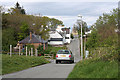
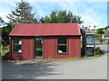
Nearby Images from Geograph Britain and Ireland:
©2012(licence)
©2014(licence)

©2024(licence)
©2008(licence)
©2012(licence)
The above images may not be of the site on this page, they are loaded from Geograph.
Please Submit an Image of this site or go out and take one for us!
Click here to see more info for this site
Nearby sites
Key: Red: member's photo, Blue: 3rd party photo, Yellow: other image, Green: no photo - please go there and take one, Grey: site destroyed
Download sites to:
KML (Google Earth)
GPX (GPS waypoints)
CSV (Garmin/Navman)
CSV (Excel)
To unlock full downloads you need to sign up as a Contributory Member. Otherwise downloads are limited to 50 sites.
Turn off the page maps and other distractions
Nearby sites listing. In the following links * = Image available
951m NNE 24° Armadale Bay Cairn Cairn (NG63680390)
1.1km NE 42° Cists near Armadale Pier Burial Chamber or Dolmen (NG640038)
2.1km SW 220° Dun Chlo (Tormore)* Stone Fort or Dun (NG618015)
3.0km NNE 24° Dun Ela* Stone Fort or Dun (NG64640569)
3.4km SW 228° Dun A'Chleirich* Stone Fort or Dun (NG60590091)
4.1km SW 227° Dun Ban (Sleat)* Stone Fort or Dun (NG60030042)
4.8km NNE 32° Dun Faich Stone Fort or Dun (NG66020697)
6.7km WNW 282° Dun Geilbt* Stone Fort or Dun (NG56750480)
6.9km E 82° Dun Ban (Doune)* Stone Fort or Dun (NG70110362)
7.3km NE 40° Dun Choinnich* Broch or Nuraghe (NG68290834)
8.2km NNE 31° Dun Knock (Toravaig)* Stone Fort or Dun (NG679098)
8.4km NNW 327° Cnoc an Temple* Burial Chamber or Dolmen (NG591104)
9.0km N 355° Meal-da-Bheinn* Stone Circle (NG629121)
9.9km NNW 341° Inver Aulavaig 2* Cairn (NG6059112629)
9.9km NNW 340° Inver Aulavaig 1* Cairn (NG60441259)
10.2km NE 39° Dun Ban (Camascross) Stone Fort or Dun (NG70121065)
10.2km N 349° Teampuill Chaon* Early Christian Sculptured Stone (NG61831321)
10.4km NNW 348° Tobar Chaon* Holy Well or Sacred Spring (NG61711340)
13.2km N 349° Dun Boreraig Fort* Hillfort (NG615162)
13.4km NW 310° Dun Grugaig (Skye)* Stone Fort or Dun (NG53541229)
13.4km N 351° Dun Boreraig Stone* Standing Stone (Menhir) (NG61951638)
14.3km NW 318° Dun Liath (Elgol)* Broch or Nuraghe (NG54331427)
14.4km NW 317° Allt Na Cille Souterrain (Fogou, Earth House) (NG539141)
14.9km NNW 343° Dun Kearstack* Hillfort (NG596175)
14.9km N 4° Heaste Stone Standing Stone (Menhir) (NG6505117847)
View more nearby sites and additional images


 We would like to know more about this location. Please feel free to add a brief description and any relevant information in your own language.
 Wir möchten mehr über diese Stätte erfahren. Bitte zögern Sie nicht, eine kurze Beschreibung und relevante Informationen in Deutsch hinzuzufügen.
 Nous aimerions en savoir encore un peu sur les lieux. S'il vous plaît n'hesitez pas à ajouter une courte description et tous les renseignements pertinents dans votre propre langue.
 Quisieramos informarnos un poco más de las lugares. No dude en añadir una breve descripción y otros datos relevantes en su propio idioma.