<< Our Photo Pages >> Dun A'Chleirich - Stone Fort or Dun in Scotland in Isle of Skye
Submitted by Andy B on Thursday, 26 August 2010 Page Views: 2764
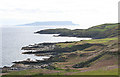
Multi-periodSite Name: Dun A'ChleirichCountry: Scotland County: Isle of Skye Type: Stone Fort or Dun
Nearest Town: Broadford Nearest Village: Armadale
Map Ref: NG60590091
Latitude: 57.036930N Longitude: 5.947739W
Condition:
| 5 | Perfect |
| 4 | Almost Perfect |
| 3 | Reasonable but with some damage |
| 2 | Ruined but still recognisable as an ancient site |
| 1 | Pretty much destroyed, possibly visible as crop marks |
| 0 | No data. |
| -1 | Completely destroyed |
| 5 | Superb |
| 4 | Good |
| 3 | Ordinary |
| 2 | Not Good |
| 1 | Awful |
| 0 | No data. |
| 5 | Can be driven to, probably with disabled access |
| 4 | Short walk on a footpath |
| 3 | Requiring a bit more of a walk |
| 2 | A long walk |
| 1 | In the middle of nowhere, a nightmare to find |
| 0 | No data. |
| 5 | co-ordinates taken by GPS or official recorded co-ordinates |
| 4 | co-ordinates scaled from a detailed map |
| 3 | co-ordinates scaled from a bad map |
| 2 | co-ordinates of the nearest village |
| 1 | co-ordinates of the nearest town |
| 0 | no data |
Internal Links:
External Links:
")
It is defended by a stone wall, now very dilapidated, built round the edge of the summit and following the sinuosities of the rock. Internally the dun measures some 52ft NW-SE, and 51ft NE-SW. In some places the outer face of the wall shows 3ft in height, but generally it is very dilapidated. On the NW towards the land, the wall has been of considerable strength, as it now shows a rough mound of stones, 20ft in breadth and 3ft in height at other parts the wall varies from 4ft 3ins - 6ft in thickness.
In the S corner of the enclosure are the stone foundations of a roughly circular structure, about 12ft in diameter internally, the remains of the wall being spread over a width of about 5ft.
The entrance was probably at the E end of the NW wall oppisite the approach ridge.
Source: Highland HER
You may be viewing yesterday's version of this page. To see the most up to date information please register for a free account.
")
Do not use the above information on other web sites or publications without permission of the contributor.
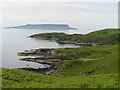
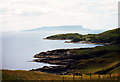
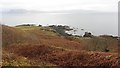
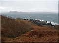
Nearby Images from Geograph Britain and Ireland:
©2014(licence)
©2011(licence)
©2012(licence)
©2011(licence)
©2014(licence)
The above images may not be of the site on this page, they are loaded from Geograph.
Please Submit an Image of this site or go out and take one for us!
Click here to see more info for this site
Nearby sites
Key: Red: member's photo, Blue: 3rd party photo, Yellow: other image, Green: no photo - please go there and take one, Grey: site destroyed
Download sites to:
KML (Google Earth)
GPX (GPS waypoints)
CSV (Garmin/Navman)
CSV (Excel)
To unlock full downloads you need to sign up as a Contributory Member. Otherwise downloads are limited to 50 sites.
Turn off the page maps and other distractions
Nearby sites listing. In the following links * = Image available
742m SW 225° Dun Ban (Sleat)* Stone Fort or Dun (NG60030042)
1.3km ENE 61° Dun Chlo (Tormore)* Stone Fort or Dun (NG618015)
3.4km NE 48° Dun Acardinon* Stone Fort or Dun (NG63250305)
4.3km NE 43° Armadale Bay Cairn Cairn (NG63680390)
4.5km NE 46° Cists near Armadale Pier Burial Chamber or Dolmen (NG640038)
5.5km NW 312° Dun Geilbt* Stone Fort or Dun (NG56750480)
6.2km NE 37° Dun Ela* Stone Fort or Dun (NG64640569)
8.1km NE 38° Dun Faich Stone Fort or Dun (NG66020697)
9.6km NNW 348° Cnoc an Temple* Burial Chamber or Dolmen (NG591104)
9.9km ENE 71° Dun Ban (Doune)* Stone Fort or Dun (NG70110362)
10.7km NE 43° Dun Choinnich* Broch or Nuraghe (NG68290834)
11.4km N 8° Meal-da-Bheinn* Stone Circle (NG629121)
11.5km NE 36° Dun Knock (Toravaig)* Stone Fort or Dun (NG679098)
11.7km N 356° Inver Aulavaig 1* Cairn (NG60441259)
11.7km N 357° Inver Aulavaig 2* Cairn (NG6059112629)
12.3km N 2° Teampuill Chaon* Early Christian Sculptured Stone (NG61831321)
12.5km N 2° Tobar Chaon* Holy Well or Sacred Spring (NG61711340)
13.4km NW 325° Dun Grugaig (Skye)* Stone Fort or Dun (NG53541229)
13.6km NE 41° Dun Ban (Camascross) Stone Fort or Dun (NG70121065)
14.7km NNW 332° Dun Liath (Elgol)* Broch or Nuraghe (NG54331427)
14.8km NNW 330° Allt Na Cille Souterrain (Fogou, Earth House) (NG539141)
15.3km N 0° Dun Boreraig Fort* Hillfort (NG615162)
15.3km NNW 329° Allt Na Cille Standing Stone (Menhir) (NG53501453)
15.5km N 2° Dun Boreraig Stone* Standing Stone (Menhir) (NG61951638)
15.7km NNW 335° An Reidhean* Stone Circle (NG54701548)
View more nearby sites and additional images


 We would like to know more about this location. Please feel free to add a brief description and any relevant information in your own language.
 Wir möchten mehr über diese Stätte erfahren. Bitte zögern Sie nicht, eine kurze Beschreibung und relevante Informationen in Deutsch hinzuzufügen.
 Nous aimerions en savoir encore un peu sur les lieux. S'il vous plaît n'hesitez pas à ajouter une courte description et tous les renseignements pertinents dans votre propre langue.
 Quisieramos informarnos un poco más de las lugares. No dude en añadir una breve descripción y otros datos relevantes en su propio idioma.