<< Our Photo Pages >> Sannaig - Stone Row / Alignment in Scotland in Isle of Jura
Submitted by Tom_Bullock on Wednesday, 09 June 2004 Page Views: 9062
Neolithic and Bronze AgeSite Name: SannaigCountry: Scotland County: Isle of Jura Type: Stone Row / Alignment
Nearest Village: Craighouse / Cabrach
Map Ref: NR51846480 Landranger Map Number: 61
Latitude: 55.812507N Longitude: 5.962443W
Condition:
| 5 | Perfect |
| 4 | Almost Perfect |
| 3 | Reasonable but with some damage |
| 2 | Ruined but still recognisable as an ancient site |
| 1 | Pretty much destroyed, possibly visible as crop marks |
| 0 | No data. |
| -1 | Completely destroyed |
| 5 | Superb |
| 4 | Good |
| 3 | Ordinary |
| 2 | Not Good |
| 1 | Awful |
| 0 | No data. |
| 5 | Can be driven to, probably with disabled access |
| 4 | Short walk on a footpath |
| 3 | Requiring a bit more of a walk |
| 2 | A long walk |
| 1 | In the middle of nowhere, a nightmare to find |
| 0 | No data. |
| 5 | co-ordinates taken by GPS or official recorded co-ordinates |
| 4 | co-ordinates scaled from a detailed map |
| 3 | co-ordinates scaled from a bad map |
| 2 | co-ordinates of the nearest village |
| 1 | co-ordinates of the nearest town |
| 0 | no data |
Internal Links:
External Links:
I have visited· I would like to visit
SandyG visited on 20th Aug 2017 - their rating: Cond: 2 Amb: 2 Access: 2 Car parking is available at NR 50672 64747. From here follow the forest track to NR 51986 64770. Enter the forest and walk uphill until you reach the small clearing containing the stones. Access from the north is likely to be hampered or prevented by the deer fence. Whilst no ticks were encountered during the visit it would be wise to take particular care when visiting this row.

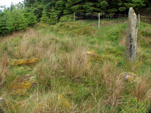
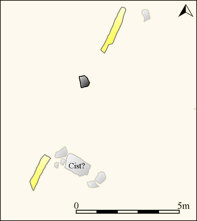
Aside from a 6-foot standing stone, there is a prostrate stone 9-feet long, a 7-foot prostrate stone 15-feet to the S, and a prostrate rectangular slab 4-feet long next to the latter. The flat face of the standing stone is aligned N-S, but the alignment between the standing stone and the nearby 9-foot prostrate stone is NNE-SSW (azimuth = 200 degrees). It is difficult to determine where the additional two prostrate stones fit into the original arrangement.
Canmore site no. 38247.
Update November 2019: This alignment is featured on the Stone Rows of Great Britain website - see their entry for Sannaig, which includes a description, a plan of the row from a survey carried out in August 2017, a drawing of the stones from 1932 by Rideout, photographs of the alignment and its individual stones, access information and a list of online resources for more information.
The SRoGB asks visitors to note: "Access from the north is likely to be hampered or prevented by the deer fence. Whilst no ticks were encountered during the visit it would be wise to take particular care when visiting this row".
Note: Tom has selected some really obscure sites to show his recent progress. His next featured site is Craigaid Row on the Isle of Mull (Ulva)
You may be viewing yesterday's version of this page. To see the most up to date information please register for a free account.


Do not use the above information on other web sites or publications without permission of the contributor.
Click here to see more info for this site
Nearby sites
Key: Red: member's photo, Blue: 3rd party photo, Yellow: other image, Green: no photo - please go there and take one, Grey: site destroyed
Download sites to:
KML (Google Earth)
GPX (GPS waypoints)
CSV (Garmin/Navman)
CSV (Excel)
To unlock full downloads you need to sign up as a Contributory Member. Otherwise downloads are limited to 50 sites.
Turn off the page maps and other distractions
Nearby sites listing. In the following links * = Image available
1.5km SW 222° Strone Farm* Standing Stones (NR50786375)
1.8km NNW 339° Carragh a'Ghlinne* Stone Row / Alignment (NR5128566490)
2.1km SW 216° Cladh Chlainn Iain* Chambered Cairn (NR50476315)
5.4km W 267° Camas An Staca* Standing Stone (Menhir) (NR46416479)
7.3km NNE 21° Knockrome West* Standing Stone (Menhir) (NR54847144)
7.4km NNE 22° Knockrome east* Standing Stone (Menhir) (NR55037148)
8.1km NNE 28° Ardfernal* Natural Stone / Erratic / Other Natural Feature (NR5600971718)
11.0km W 280° Scanistle Standing Stone (Menhir) (NR41086724)
11.5km W 263° Mullach Dubh* Standing Stone (Menhir) (NR40366412)
11.5km SSW 204° Ardtalla Standing Stone (Menhir) (NR46575456)
11.9km W 267° Knocklearoch* Standing Stones (NR3989164860)
13.1km WNW 283° Finlaggan* Standing Stone (Menhir) (NR3927668559)
13.1km SSW 202° Trudernish* Standing Stone (Menhir) (NR46295290)
15.2km SSW 200° Kildalton Cross* Ancient Cross (NR4580250830)
15.7km W 277° Baile Tarbhach Standing Stone (Menhir) (NR36366762)
16.3km WSW 255° Gortanilivorrie Standing Stone (Menhir) (NR35816138)
16.4km WSW 252° Neriby (Bridgend) Standing Stone (Menhir) (NR35956053)
17.2km W 277° Beinn Cham Standing Stones (NR349679)
17.3km SSW 203° Ardilistry* Stone Circle (NR44264919)
17.7km WNW 283° Clach an Tiompain Standing Stone (Menhir) (NR34756977)
17.8km SE 124° Cnoc nan Gobhar Stone* Standing Stone (Menhir) (NR6607454042)
18.0km SE 127° Kinerarach (Gigha)* Standing Stone (Menhir) (NR6568453210)
18.2km W 265° Knockdon Standing Stone (Menhir) (NR33616424)
18.3km SSW 204° Cnoc Rhaonastil Standing Stone (Menhir) (NR434485)
18.4km SSW 203° Clachan Cean Ile* Standing Stones (NR43684832)
View more nearby sites and additional images


 We would like to know more about this location. Please feel free to add a brief description and any relevant information in your own language.
 Wir möchten mehr über diese Stätte erfahren. Bitte zögern Sie nicht, eine kurze Beschreibung und relevante Informationen in Deutsch hinzuzufügen.
 Nous aimerions en savoir encore un peu sur les lieux. S'il vous plaît n'hesitez pas à ajouter une courte description et tous les renseignements pertinents dans votre propre langue.
 Quisieramos informarnos un poco más de las lugares. No dude en añadir una breve descripción y otros datos relevantes en su propio idioma.