


<< Our Photo Pages >> Druim Nan Slochd Dun - Hillfort in Scotland in Isle of Skye
Submitted by uisdean on Friday, 04 May 2007 Page Views: 4993
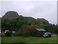
Iron Age and Later PrehistorySite Name: Druim Nan Slochd DunCountry: Scotland
NOTE: This site is 2.2 km away from the location you searched for.
County: Isle of Skye Type: Hillfort
Nearest Town: Portree Nearest Village: Flodigarry
Map Ref: NG463721
Latitude: 57.667040N Longitude: 6.255866W
Condition:
| 5 | Perfect |
| 4 | Almost Perfect |
| 3 | Reasonable but with some damage |
| 2 | Ruined but still recognisable as an ancient site |
| 1 | Pretty much destroyed, possibly visible as crop marks |
| 0 | No data. |
| -1 | Completely destroyed |
| 5 | Superb |
| 4 | Good |
| 3 | Ordinary |
| 2 | Not Good |
| 1 | Awful |
| 0 | No data. |
| 5 | Can be driven to, probably with disabled access |
| 4 | Short walk on a footpath |
| 3 | Requiring a bit more of a walk |
| 2 | A long walk |
| 1 | In the middle of nowhere, a nightmare to find |
| 0 | No data. |
| 5 | co-ordinates taken by GPS or official recorded co-ordinates |
| 4 | co-ordinates scaled from a detailed map |
| 3 | co-ordinates scaled from a bad map |
| 2 | co-ordinates of the nearest village |
| 1 | co-ordinates of the nearest town |
| 0 | no data |
Internal Links:
External Links:
")
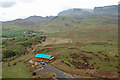
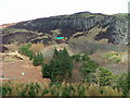
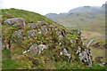
Remains of a dun occupying a commanding position on a knoll above Flodigarry. Some walling survives consisting of courses of large stones.
The approach to the dun involves some scrambling; it is best approached along the ridge from the North.
You may be viewing yesterday's version of this page. To see the most up to date information please register for a free account.
")
Do not use the above information on other web sites or publications without permission of the contributor.
Nearby Images from Geograph Britain and Ireland:
©2010(licence)
©2010(licence)
©2010(licence)
©2008(licence)
©2012(licence)
The above images may not be of the site on this page, they are loaded from Geograph.
Please Submit an Image of this site or go out and take one for us!
Click here to see more info for this site
Nearby sites
Key: Red: member's photo, Blue: 3rd party photo, Yellow: other image, Green: no photo - please go there and take one, Grey: site destroyed
Download sites to:
KML (Google Earth)
GPX (GPS waypoints)
CSV (Garmin/Navman)
CSV (Excel)
To unlock full downloads you need to sign up as a Contributory Member. Otherwise downloads are limited to 50 sites.
Turn off the page maps and other distractions
Nearby sites listing. In the following links * = Image available
166m SE 144° Dun Flodigarry* Broch or Nuraghe (NG46397196)
291m SE 145° Tobar Kiltavie, Flodigarry* Holy Well or Sacred Spring (NG46457185)
2.3km SSE 156° Loch Sheanta* Holy Well or Sacred Spring (NG471699)
2.7km S 173° Dun Vallerain* Hillfort (NG46476943)
3.8km S 180° Dun Beag (Brogaig)* Hillfort (NG46076827)
4.5km SE 138° An Corran* Ancient Mine, Quarry or other Industry (NG49106860)
4.6km SE 145° Carn Ban (Skye)* Cairn (NG487682)
5.6km SE 141° Cadha Riach* Chambered Tomb (NG49556757)
5.6km SSW 201° Cleat Hillfort Artificial Mound (NG440670)
6.0km SSE 151° Dun Smail* Stone Fort or Dun (NG489667)
6.8km W 264° Osmigarry* Standing Stone (Menhir) (NG3943571814)
7.7km WSW 248° Kilvaxter souterrain* Souterrain (Fogou, Earth House) (NG3900569619)
8.1km SE 145° Dun Grianan* Broch or Nuraghe (NG505652)
8.8km SSE 149° Dun Raisaburgh* Broch or Nuraghe (NG50326427)
8.8km SE 146° Raisaburgh Cairn* Cairn (NG508645)
9.0km W 263° Dun Bornaskitaig* Broch or Nuraghe (NG37267161)
9.3km SE 143° Dun Dearg* Stone Fort or Dun (NG51376430)
9.6km WSW 246° Carn Liath (Skye)* Chambered Cairn (NG372688)
10.3km SSE 150° Dun Connavern* Stone Fort or Dun (NG50856284)
10.6km WSW 255° Dun Liath (Bornesketaig)* Stone Fort or Dun (NG359700)
11.6km SSW 213° Uig.* Standing Stone (Menhir) (NG394628)
11.6km SW 227° Dun Skudiburgh* Stone Fort or Dun (NG373647)
12.6km SSE 159° Dun Taivson Stone Fort or Dun (NG56)
13.2km NW 308° Weeping Stone (Fladaigh Chuain) Natural Stone / Erratic / Other Natural Feature (NG36388091)
14.2km SSE 153° Upper Tote* Cairn (NG51865898)
View more nearby sites and additional images


 We would like to know more about this location. Please feel free to add a brief description and any relevant information in your own language.
 Wir möchten mehr über diese Stätte erfahren. Bitte zögern Sie nicht, eine kurze Beschreibung und relevante Informationen in Deutsch hinzuzufügen.
 Nous aimerions en savoir encore un peu sur les lieux. S'il vous plaît n'hesitez pas à ajouter une courte description et tous les renseignements pertinents dans votre propre langue.
 Quisieramos informarnos un poco más de las lugares. No dude en añadir una breve descripción y otros datos relevantes en su propio idioma.