

<< Our Photo Pages >> Kensaleyre N Cairn - Cairn in Scotland in Isle of Skye
Submitted by markj99 on Saturday, 03 April 2021 Page Views: 629
Neolithic and Bronze AgeSite Name: Kensaleyre N CairnCountry: Scotland County: Isle of Skye Type: Cairn
Nearest Town: Portree Nearest Village: Kensaleyre
Map Ref: NG42555064
Latitude: 57.472695N Longitude: 6.295803W
Condition:
| 5 | Perfect |
| 4 | Almost Perfect |
| 3 | Reasonable but with some damage |
| 2 | Ruined but still recognisable as an ancient site |
| 1 | Pretty much destroyed, possibly visible as crop marks |
| 0 | No data. |
| -1 | Completely destroyed |
| 5 | Superb |
| 4 | Good |
| 3 | Ordinary |
| 2 | Not Good |
| 1 | Awful |
| 0 | No data. |
| 5 | Can be driven to, probably with disabled access |
| 4 | Short walk on a footpath |
| 3 | Requiring a bit more of a walk |
| 2 | A long walk |
| 1 | In the middle of nowhere, a nightmare to find |
| 0 | No data. |
| 5 | co-ordinates taken by GPS or official recorded co-ordinates |
| 4 | co-ordinates scaled from a detailed map |
| 3 | co-ordinates scaled from a bad map |
| 2 | co-ordinates of the nearest village |
| 1 | co-ordinates of the nearest town |
| 0 | no data |
Internal Links:
External Links:
")
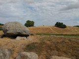
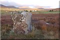
According to Canmore ID 11325 it has "been truncated by road improvement, and lost as much as a third of its diameter from its western side". Before 1987 it measured c. 66 feet on the N-S Axis and 7 feet high.
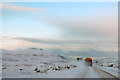
There is a convenient lay-by c. 50 yards S of Kensaleyre N Cairn making it easy to explore the nearby cairns and standing stone.
You may be viewing yesterday's version of this page. To see the most up to date information please register for a free account.
")
Do not use the above information on other web sites or publications without permission of the contributor.
Nearby Images from Geograph Britain and Ireland:
©2022(licence)
©2007(licence)
©2006(licence)
©2011(licence)
©2007(licence)
The above images may not be of the site on this page, they are loaded from Geograph.
Please Submit an Image of this site or go out and take one for us!
Click here to see more info for this site
Nearby sites
Key: Red: member's photo, Blue: 3rd party photo, Yellow: other image, Green: no photo - please go there and take one, Grey: site destroyed
Download sites to:
KML (Google Earth)
GPX (GPS waypoints)
CSV (Garmin/Navman)
CSV (Excel)
To unlock full downloads you need to sign up as a Contributory Member. Otherwise downloads are limited to 50 sites.
Turn off the page maps and other distractions
Nearby sites listing. In the following links * = Image available
70m SE 131° Kensaleyre S Cairn* Cairn (NG42605059)
78m NE 36° Kensalyre Stone* Standing Stone (Menhir) (NG426507)
857m NW 317° Carn Liath (Kensaleyre)* Chambered Cairn (NG420513)
1.6km SSW 193° Tote, Skye* Class I Pictish Symbol Stone (NG421491)
1.9km NW 305° Dun Cruinn* Stone Fort or Dun (NG411518)
1.9km NW 305° Standing stones below Dun Cruinn* Standing Stones (NG411518)
2.2km NW 326° Eyre Alignment* Stone Row / Alignment (NG4143252510)
2.3km SSW 195° St Columba's Chapel (Skeabost) Early Christian Sculptured Stone (NG41824850)
2.7km SSW 203° Dun Sgalair* Stone Fort or Dun (NG41354826)
2.9km NNW 346° Dun Eyre* Stone Fort or Dun (NG420535)
3.7km SE 131° Borve Stone Row* Stone Row / Alignment (NG452480)
4.2km NNW 335° Dun Adhamh* Stone Fort or Dun (NG410546)
4.4km SE 127° Dun Borve (Skye)* Broch or Nuraghe (NG45914772)
5.4km SE 136° Drumuie Standing Stone* Standing Stone (Menhir) (NG4606746524)
5.5km WNW 287° Dun Suladale* Broch or Nuraghe (NG374526)
6.1km WNW 297° Creagan Soillier* Stone Fort or Dun (NG37315378)
6.2km NW 323° Unnamed dun at Kingsburgh* Stone Fort or Dun (NG391558)
7.2km W 269° Dun Edinbane* Broch or Nuraghe (NG35355092)
7.9km NW 323° Dun Santavaig* Stone Fort or Dun (NG382572)
8.0km WNW 288° Dun Flashader* Broch or Nuraghe (NG351536)
8.2km ENE 62° Old Man of Storr* Rock Outcrop (NG5003853990)
8.3km SE 127° Dun Gerashader* Hillfort (NG489452)
9.1km WNW 301° Dun na h-Airde* Stone Fort or Dun (NG350558)
9.3km SE 130° Dun Torvaig* Stone Fort or Dun (NG49374422)
9.7km NNW 327° Dun Maraig* Stone Fort or Dun (NG377591)
View more nearby sites and additional images


 We would like to know more about this location. Please feel free to add a brief description and any relevant information in your own language.
 Wir möchten mehr über diese Stätte erfahren. Bitte zögern Sie nicht, eine kurze Beschreibung und relevante Informationen in Deutsch hinzuzufügen.
 Nous aimerions en savoir encore un peu sur les lieux. S'il vous plaît n'hesitez pas à ajouter une courte description et tous les renseignements pertinents dans votre propre langue.
 Quisieramos informarnos un poco más de las lugares. No dude en añadir una breve descripción y otros datos relevantes en su propio idioma.