<< Our Photo Pages >> Carn Kenidjack propped stone - Natural Stone / Erratic / Other Natural Feature in England in Cornwall
Submitted by cornishstargazer on Saturday, 18 July 2020 Page Views: 2414
Natural PlacesSite Name: Carn Kenidjack propped stoneCountry: England County: Cornwall Type: Natural Stone / Erratic / Other Natural Feature
Nearest Town: St Just
Map Ref: SW38793297
Latitude: 50.139145N Longitude: 5.657011W
Condition:
| 5 | Perfect |
| 4 | Almost Perfect |
| 3 | Reasonable but with some damage |
| 2 | Ruined but still recognisable as an ancient site |
| 1 | Pretty much destroyed, possibly visible as crop marks |
| 0 | No data. |
| -1 | Completely destroyed |
| 5 | Superb |
| 4 | Good |
| 3 | Ordinary |
| 2 | Not Good |
| 1 | Awful |
| 0 | No data. |
| 5 | Can be driven to, probably with disabled access |
| 4 | Short walk on a footpath |
| 3 | Requiring a bit more of a walk |
| 2 | A long walk |
| 1 | In the middle of nowhere, a nightmare to find |
| 0 | No data. |
| 5 | co-ordinates taken by GPS or official recorded co-ordinates |
| 4 | co-ordinates scaled from a detailed map |
| 3 | co-ordinates scaled from a bad map |
| 2 | co-ordinates of the nearest village |
| 1 | co-ordinates of the nearest town |
| 0 | no data |
Internal Links:
External Links:
I have visited· I would like to visit
TheCaptain visited on 10th Jun 2023 Big walk round the Botallack mines area today, starting off by walking up to the top of Carn Kenidjack. Some lovely cattle grazing up here, who don't seem to mind my presence as I greet them all. I am not convinced of anything other than natural up here. Everything is hazy up here today with a sea mist rolling in, so I miss out on the views.
LiveAndrew visited on 8th Jul 2021 - their rating: Cond: 5 Amb: 5 Access: 3
lucasn visited - their rating: Cond: 4 Amb: 4 Access: 3
cornishstargazer have visited here
Average ratings for this site from all visit loggers: Condition: 4.5 Ambience: 4.5 Access: 3
")
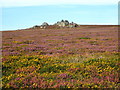
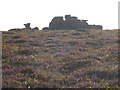
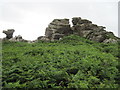
The slab is substantial and has the appearance of a capstone from a distance. It is easily visible from Chun Quoit 1.7km away. Standing at Chun Quoit in the Neolithic an observer would see the winter solstice sunset behind this propped feature.
You may be viewing yesterday's version of this page. To see the most up to date information please register for a free account.
")
")
")
Do not use the above information on other web sites or publications without permission of the contributor.
Nearby Images from Geograph Britain and Ireland:

©2024(licence)
©2009(licence)

©2024(licence)
©2009(licence)
©2009(licence)
The above images may not be of the site on this page, they are loaded from Geograph.
Please Submit an Image of this site or go out and take one for us!
Click here to see more info for this site
Nearby sites
Key: Red: member's photo, Blue: 3rd party photo, Yellow: other image, Green: no photo - please go there and take one, Grey: site destroyed
Download sites to:
KML (Google Earth)
GPX (GPS waypoints)
CSV (Garmin/Navman)
CSV (Excel)
To unlock full downloads you need to sign up as a Contributory Member. Otherwise downloads are limited to 50 sites.
Turn off the page maps and other distractions
Nearby sites listing. In the following links * = Image available
32m NNE 16° Carn Kenidjack* Rock Outcrop (SW388330)
319m ESE 102° Carnyorth Circles Ancient Village or Settlement (SW39103289)
410m SE 128° Carn Kenidjack Hut Circle and Enclosure Ancient Village or Settlement (SW391327)
413m SE 145° Kenidjack Common holed stones* Stone Row / Alignment (SW39013262)
422m SSE 164° Truthwall Common barrows* Round Barrow(s) (SW38893256)
431m SW 223° Truthwall Commom Ancient Village or Settlement (SW38483267)
454m NE 47° Portheras Barrow* Round Barrow(s) (SW39143326)
464m ENE 79° Boslow Cross* Ancient Cross (SW39253304)
545m WNW 285° Carnbean Barrows* Round Barrow(s) (SW38273314)
613m S 189° Tregeseal East* Stone Circle (SW38663237)
616m SSW 194° Tregeseal C* Stone Circle (SW38613238)
627m SSW 200° Tregeseal W Stone Circle (SW38553239)
667m NE 52° Woon Gumpus Barrows Round Barrow(s) (SW39343335)
728m SW 234° Truthwall Barrow* Round Barrow(s) (SW38183257)
776m WSW 243° No Go By Hill Field System* Misc. Earthwork (SW38083265)
790m WSW 253° Camyorth Field System Misc. Earthwork (SW38023278)
814m E 79° Woon Gumpus Menhirs* Natural Stone / Erratic / Other Natural Feature (SW3960033079)
885m NNW 329° Carn Eanes Standing stone* Modern Stone Circle etc (SW38373375)
916m E 79° Woon Gumpas Common Tumuli* Barrow Cemetery (SW397331)
920m SSW 194° Carn Vres* Round Barrow(s) (SW38523209)
1.0km SSW 196° Lower Bostraze Misc. Earthwork (SW38473201)
1.1km N 352° Higher Boscaswell Well* Holy Well or Sacred Spring (SW3869434032)
1.1km NNW 334° Carn Eanes Cairn* Cairn (SW38373397)
1.1km SW 219° Tregeseal Barrow* Chambered Tomb (SW38043214)
1.1km WSW 253° Higher Botallack Enclosure* Ancient Village or Settlement (SW377327)
View more nearby sites and additional images


 We would like to know more about this location. Please feel free to add a brief description and any relevant information in your own language.
 Wir möchten mehr über diese Stätte erfahren. Bitte zögern Sie nicht, eine kurze Beschreibung und relevante Informationen in Deutsch hinzuzufügen.
 Nous aimerions en savoir encore un peu sur les lieux. S'il vous plaît n'hesitez pas à ajouter une courte description et tous les renseignements pertinents dans votre propre langue.
 Quisieramos informarnos un poco más de las lugares. No dude en añadir una breve descripción y otros datos relevantes en su propio idioma.