


<< Our Photo Pages >> Gribba (Letcha) kerb cairn - Cairn in England in Cornwall
Submitted by Bladup on Thursday, 28 November 2013 Page Views: 2823
Neolithic and Bronze AgeSite Name: Gribba (Letcha) kerb cairnCountry: England County: Cornwall Type: Cairn
Map Ref: SW35703025
Latitude: 50.113365N Longitude: 5.698277W
Condition:
| 5 | Perfect |
| 4 | Almost Perfect |
| 3 | Reasonable but with some damage |
| 2 | Ruined but still recognisable as an ancient site |
| 1 | Pretty much destroyed, possibly visible as crop marks |
| 0 | No data. |
| -1 | Completely destroyed |
| 5 | Superb |
| 4 | Good |
| 3 | Ordinary |
| 2 | Not Good |
| 1 | Awful |
| 0 | No data. |
| 5 | Can be driven to, probably with disabled access |
| 4 | Short walk on a footpath |
| 3 | Requiring a bit more of a walk |
| 2 | A long walk |
| 1 | In the middle of nowhere, a nightmare to find |
| 0 | No data. |
| 5 | co-ordinates taken by GPS or official recorded co-ordinates |
| 4 | co-ordinates scaled from a detailed map |
| 3 | co-ordinates scaled from a bad map |
| 2 | co-ordinates of the nearest village |
| 1 | co-ordinates of the nearest town |
| 0 | no data |
Internal Links:
External Links:
I have visited· I would like to visit
lucasn visited on 29th May 2021 - their rating: Cond: 2 Amb: 5 Access: 3
 kerb cairn (PID:115460)")
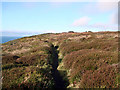
It's right by and to the east of the coast path.
You may be viewing yesterday's version of this page. To see the most up to date information please register for a free account.
 kerb cairn (PID:219347)")
 kerb cairn (PID:115461)")
 kerb cairn (PID:115459)")
 kerb cairn (PID:115458)")
Do not use the above information on other web sites or publications without permission of the contributor.
Nearby Images from Geograph Britain and Ireland:
©2012(licence)

©2010(licence)
©2021(licence)
©2012(licence)
©2007(licence)
The above images may not be of the site on this page, they are loaded from Geograph.
Please Submit an Image of this site or go out and take one for us!
Click here to see more info for this site
Nearby sites
Key: Red: member's photo, Blue: 3rd party photo, Yellow: other image, Green: no photo - please go there and take one, Grey: site destroyed
Download sites to:
KML (Google Earth)
GPX (GPS waypoints)
CSV (Garmin/Navman)
CSV (Excel)
To unlock full downloads you need to sign up as a Contributory Member. Otherwise downloads are limited to 50 sites.
Turn off the page maps and other distractions
Nearby sites listing. In the following links * = Image available
429m SSE 165° Carn Polpry Ring cairns* Ring Cairn (SW35792983)
558m SSE 167° Boscregan Cairns* Cairn (SW358297)
1.0km NNW 347° Carn Gluze* Chambered Cairn (SW35523125)
1.2km ENE 70° Tom Thumb Rock* Rock Outcrop (SW36843061)
1.3km SE 143° Nanquidno Cross* Early Christian Sculptured Stone (SW3644629140)
1.4km SSE 159° Nanjulian courtyard house settlement* Ancient Village or Settlement (SW36152888)
1.7km NNW 340° Cape Cornwall* Ancient Cross (SW352319)
1.9km NE 45° The Selus Stone* Early Christian Sculptured Stone (SW371315)
1.9km SE 142° Nanquidno Downs Tumulus and Hut Circles* Round Barrow(s) (SW368287)
2.2km NE 45° Venton East* Holy Well or Sacred Spring (SW3732931708)
2.2km E 79° Bosworlas Lehau* Rock Outcrop (SW37873055)
2.2km N 354° Kenidjack Cairn Circle* Ring Cairn (SW35593247)
2.3km ESE 102° Lower Numphra Tumulus* Round Barrow(s) (SW3796529644)
2.4km N 352° Kenidjack Cliff Castle* Promontory Fort / Cliff Castle (SW355326)
3.0km SE 146° Tregiffian Vean* Chambered Tomb (SW37252773)
3.0km NE 48° Tregeseal Barrow* Chambered Tomb (SW38043214)
3.1km SSE 168° Escalls Cliff Cairn* Cairn (SW362272)
3.2km SSE 147° Trevedra Common Tumuli Barrow Cemetery (SW37292752)
3.2km NE 36° Higher Botallack Enclosure* Ancient Village or Settlement (SW377327)
3.3km NE 55° Lower Bostraze Misc. Earthwork (SW38473201)
3.3km SE 130° Chapel Carn Brea Menhir* Standing Stone (Menhir) (SW3812927987)
3.4km NE 54° Carn Vres* Round Barrow(s) (SW38523209)
3.4km NE 42° No Go By Hill Field System* Misc. Earthwork (SW38083265)
3.4km NE 44° Truthwall Barrow* Round Barrow(s) (SW38183257)
3.4km ESE 121° Carn Brea Hut circles and Tumulus* Round Barrow(s) (SW3853428372)
View more nearby sites and additional images


 We would like to know more about this location. Please feel free to add a brief description and any relevant information in your own language.
 Wir möchten mehr über diese Stätte erfahren. Bitte zögern Sie nicht, eine kurze Beschreibung und relevante Informationen in Deutsch hinzuzufügen.
 Nous aimerions en savoir encore un peu sur les lieux. S'il vous plaît n'hesitez pas à ajouter une courte description et tous les renseignements pertinents dans votre propre langue.
 Quisieramos informarnos un poco más de las lugares. No dude en añadir una breve descripción y otros datos relevantes en su propio idioma.