


<< Our Photo Pages >> Dun Ban (Loch Hornaraigh) - Stone Fort or Dun in Scotland in North Uist
Submitted by Andy B on Tuesday, 13 April 2010 Page Views: 5724
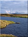
Multi-periodSite Name: Dun Ban (Loch Hornaraigh)Country: Scotland County: North Uist Type: Stone Fort or Dun
Map Ref: NF8697956930
Latitude: 57.494059N Longitude: 7.226753W
Condition:
| 5 | Perfect |
| 4 | Almost Perfect |
| 3 | Reasonable but with some damage |
| 2 | Ruined but still recognisable as an ancient site |
| 1 | Pretty much destroyed, possibly visible as crop marks |
| 0 | No data. |
| -1 | Completely destroyed |
| 5 | Superb |
| 4 | Good |
| 3 | Ordinary |
| 2 | Not Good |
| 1 | Awful |
| 0 | No data. |
| 5 | Can be driven to, probably with disabled access |
| 4 | Short walk on a footpath |
| 3 | Requiring a bit more of a walk |
| 2 | A long walk |
| 1 | In the middle of nowhere, a nightmare to find |
| 0 | No data. |
| 5 | co-ordinates taken by GPS or official recorded co-ordinates |
| 4 | co-ordinates scaled from a detailed map |
| 3 | co-ordinates scaled from a bad map |
| 2 | co-ordinates of the nearest village |
| 1 | co-ordinates of the nearest town |
| 0 | no data |
Internal Links:
External Links:
I have visited· I would like to visit
Andy B has visited here
 (PID:55747)")
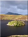
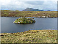
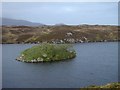
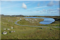
An ancient fort in Loch Hornaraigh.
You may be viewing yesterday's version of this page. To see the most up to date information please register for a free account.
 (PID:259517)")
Do not use the above information on other web sites or publications without permission of the contributor.
Andy B has found this location on Google Street View:
Nearby Images from Geograph Britain and Ireland:
©2010(licence)
©2009(licence)
©2006(licence)
©2009(licence)
©2010(licence)
The above images may not be of the site on this page, they are loaded from Geograph.
Please Submit an Image of this site or go out and take one for us!
Click here to see more info for this site
Nearby sites
Key: Red: member's photo, Blue: 3rd party photo, Yellow: other image, Green: no photo - please go there and take one, Grey: site destroyed
Download sites to:
KML (Google Earth)
GPX (GPS waypoints)
CSV (Garmin/Navman)
CSV (Excel)
To unlock full downloads you need to sign up as a Contributory Member. Otherwise downloads are limited to 50 sites.
Turn off the page maps and other distractions
Nearby sites listing. In the following links * = Image available
544m NW 319° Grimsay, Bagh Nam Feadhag* Ancient Village or Settlement (NF8665257367)
569m NNE 26° Meall Na Hoa Cairn (NF8727157420)
3.0km NE 48° Eaval, An Dunan Promontory Fort / Cliff Castle (NF8937358746)
3.0km NNE 28° Dun An T-Siaman Stone Fort or Dun (NF8858759495)
3.4km NNW 328° Barp Hacklett Chambered Cairn (NF85395993)
3.9km SW 217° Benbencula, Hacklett Ancient Village or Settlement (NF8434753976)
4.0km SW 215° Hacklett Standing Stone* Standing Stone (Menhir) (NF8444453837)
4.3km ENE 57° Beinn Na H-aire Souterrain (Fogou, Earth House) (NF90735898)
4.5km N 355° Cnoc Na File Cairn (NF869614)
4.5km WSW 255° Gramisdale* Stone Circle (NF82515613)
4.7km NW 311° Caravat Barp* Passage Grave (NF837603)
4.8km WSW 245° Suidhheachadh Sealg* Stone Circle (NF82495521)
5.0km NW 307° Carinish* Stone Circle (NF83236020)
5.4km NW 322° Possible Carved Footprints near Beinn Na Coille Carving (NF8398761447)
5.7km WSW 245° Olabhat Standing Stone* Standing Stone (Menhir) (NF8160754868)
6.1km NNW 330° Oban Nam Fiadh* Chambered Cairn (NF84296244)
6.3km NW 325° Ultach Fhinn Standing Stone (Menhir) (NF83766235)
6.7km NW 324° Leac A' Mhiosachan Standing Stones (NF83506266)
6.7km NNW 328° Loch Glen Na Feannag* Chambered Cairn (NF83876288)
6.7km SW 231° Stiaraval* Standing Stone (Menhir) (NF8143053134)
6.8km NW 323° Chambered cairn 200m WNW of Craonaval* Chambered Cairn (NF83316271)
6.9km SW 225° Airidh na h-aon Oidche Chambered Cairn* Chambered Cairn (NF81705247)
7.0km NW 324° Cairn 330m NW of Craonaval* Cairn (NF83346290)
7.1km NW 324° Cairn 430m NW of Craonaval* Cairn (NF83236297)
7.2km SW 229° Stiaraval Chambered Cairn* Chambered Cairn (NF81215260)
View more nearby sites and additional images


 We would like to know more about this location. Please feel free to add a brief description and any relevant information in your own language.
 Wir möchten mehr über diese Stätte erfahren. Bitte zögern Sie nicht, eine kurze Beschreibung und relevante Informationen in Deutsch hinzuzufügen.
 Nous aimerions en savoir encore un peu sur les lieux. S'il vous plaît n'hesitez pas à ajouter une courte description et tous les renseignements pertinents dans votre propre langue.
 Quisieramos informarnos un poco más de las lugares. No dude en añadir una breve descripción y otros datos relevantes en su propio idioma.