


<< Our Photo Pages >> Geirisclett - Chambered Cairn in Scotland in North Uist
Submitted by Andy B on Tuesday, 13 September 2011 Page Views: 3309
Neolithic and Bronze AgeSite Name: GeirisclettCountry: Scotland
NOTE: This site is 0.3 km away from the location you searched for.
County: North Uist Type: Chambered Cairn
Map Ref: NF76847520
Latitude: 57.650328N Longitude: 7.419449W
Condition:
| 5 | Perfect |
| 4 | Almost Perfect |
| 3 | Reasonable but with some damage |
| 2 | Ruined but still recognisable as an ancient site |
| 1 | Pretty much destroyed, possibly visible as crop marks |
| 0 | No data. |
| -1 | Completely destroyed |
| 5 | Superb |
| 4 | Good |
| 3 | Ordinary |
| 2 | Not Good |
| 1 | Awful |
| 0 | No data. |
| 5 | Can be driven to, probably with disabled access |
| 4 | Short walk on a footpath |
| 3 | Requiring a bit more of a walk |
| 2 | A long walk |
| 1 | In the middle of nowhere, a nightmare to find |
| 0 | No data. |
| 5 | co-ordinates taken by GPS or official recorded co-ordinates |
| 4 | co-ordinates scaled from a detailed map |
| 3 | co-ordinates scaled from a bad map |
| 2 | co-ordinates of the nearest village |
| 1 | co-ordinates of the nearest town |
| 0 | no data |
Internal Links:
External Links:
I have visited· I would like to visit
Andy B has visited here
")
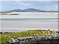
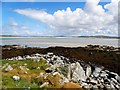
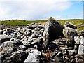
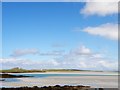
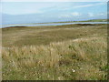
The site was visited by Miss Henshall in 1962, when the cairn was found to be considerably robbed and disturbed: on the south side stones have been built into a rough breakwater projecting from the cairn to make a sheltered landing-place.
A trial excavation was conducted by Ian Armit in 1966, in the chamber of this Neolithic tomb which had been previously investigated by Erskine Beveridge in the first decade of this century. The chamber lies at HWM and is highly vulnerable to tidal erosion and scouring. Further excavations were conducted during May 1997.
Source, with much more information: Canmore
You may be viewing yesterday's version of this page. To see the most up to date information please register for a free account.
")
")
Do not use the above information on other web sites or publications without permission of the contributor.
Nearby Images from Geograph Britain and Ireland:
©2008(licence)
©2008(licence)
©2008(licence)
©2008(licence)
©2007(licence)
The above images may not be of the site on this page, they are loaded from Geograph.
Please Submit an Image of this site or go out and take one for us!
Click here to see more info for this site
Nearby sites
Key: Red: member's photo, Blue: 3rd party photo, Yellow: other image, Green: no photo - please go there and take one, Grey: site destroyed
Download sites to:
KML (Google Earth)
GPX (GPS waypoints)
CSV (Garmin/Navman)
CSV (Excel)
To unlock full downloads you need to sign up as a Contributory Member. Otherwise downloads are limited to 50 sites.
Turn off the page maps and other distractions
Nearby sites listing. In the following links * = Image available
202m NW 323° Bac Mhic Connain Ancient Village or Settlement (NF76737537)
836m SSW 193° Airigh Mhic Ruairidh* Stone Fort or Dun (NF76597440)
849m NNE 15° Vallay (N Uist) Rock Art (NF77137600)
993m N 1° Bac Mic Connain Stone Fort or Dun (NF76947619)
1.0km SSE 153° Garry Iochdrach Ancient Village or Settlement (NF77237427)
1.1km SSE 163° Cnoc A'Comhdhalach Ancient Village or Settlement (NF77087415)
1.5km SSE 150° Eilean Maleit Ancient Village or Settlement (NF77487388)
2.0km NE 56° Rudh' An Duin Stone Fort or Dun (NF7859376180)
2.3km S 179° Buaile Risary Cup Marked Stone Rock Art (NF76697293)
2.3km S 180° Buaile Risary Wheelhouse Ancient Village or Settlement (NF76677291)
2.6km NE 55° Leac nan Cailleacha Dubha Standing Stones (NF79087650)
3.3km E 83° Sollas, Machair Leathann Ancient Village or Settlement (NF80117533)
3.7km W 263° Dun Scolpaig* Stone Fort or Dun (NF7310375028)
3.9km E 87° Dun Skellor Broch or Nuraghe (NF80757507)
4.3km SSW 202° Cleithreabhal* Chambered Cairn (NF749713)
4.4km SSW 200° South Clettraval* Standing Stone (Menhir) (NF75017118)
4.5km SSW 197° Clettraval South* Burial Chamber or Dolmen (NF75167101)
4.9km S 174° Toroghas* Standing Stones (NF77007029)
5.2km E 88° Dun Toloman Stone Fort or Dun (NF82077492)
6.3km ENE 57° Udal (Grenitote)* Ancient Village or Settlement (NF82387822)
6.4km SSE 159° Bheinn a Charra* Standing Stone (Menhir) (NF7865569075)
6.4km SSE 150° Airidhan an t- Sruthain Ghairbh* Chambered Cairn (NF79596937)
6.7km SW 231° Dun Grogary Stone Fort or Dun (NF71257141)
8.5km SE 127° Tigh Cloiche Standing Stone* Standing Stone (Menhir) (NF83246953)
8.5km SE 126° Tigh Cloiche Chambered Cairn* Chambered Cairn (NF83316958)
View more nearby sites and additional images


 We would like to know more about this location. Please feel free to add a brief description and any relevant information in your own language.
 Wir möchten mehr über diese Stätte erfahren. Bitte zögern Sie nicht, eine kurze Beschreibung und relevante Informationen in Deutsch hinzuzufügen.
 Nous aimerions en savoir encore un peu sur les lieux. S'il vous plaît n'hesitez pas à ajouter une courte description et tous les renseignements pertinents dans votre propre langue.
 Quisieramos informarnos un poco más de las lugares. No dude en añadir una breve descripción y otros datos relevantes en su propio idioma.