


<< Other Photo Pages >> Dun Scolpaig - Stone Fort or Dun in Scotland in North Uist
Submitted by SolarMegalith on Tuesday, 20 December 2011 Page Views: 4468
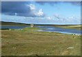
Multi-periodSite Name: Dun ScolpaigCountry: Scotland County: North Uist Type: Stone Fort or Dun
Map Ref: NF7310375028
Latitude: 57.646096N Longitude: 7.481542W
Condition:
| 5 | Perfect |
| 4 | Almost Perfect |
| 3 | Reasonable but with some damage |
| 2 | Ruined but still recognisable as an ancient site |
| 1 | Pretty much destroyed, possibly visible as crop marks |
| 0 | No data. |
| -1 | Completely destroyed |
| 5 | Superb |
| 4 | Good |
| 3 | Ordinary |
| 2 | Not Good |
| 1 | Awful |
| 0 | No data. |
| 5 | Can be driven to, probably with disabled access |
| 4 | Short walk on a footpath |
| 3 | Requiring a bit more of a walk |
| 2 | A long walk |
| 1 | In the middle of nowhere, a nightmare to find |
| 0 | No data. |
| 5 | co-ordinates taken by GPS or official recorded co-ordinates |
| 4 | co-ordinates scaled from a detailed map |
| 3 | co-ordinates scaled from a bad map |
| 2 | co-ordinates of the nearest village |
| 1 | co-ordinates of the nearest town |
| 0 | no data |
Internal Links:
External Links:
I have visited· I would like to visit
SandyG saw from a distance on 25th Aug 2015 - their rating: Cond: 2 Amb: 5 Clearly visible from the roadside.
")
Read More at Canmore.
You may be viewing yesterday's version of this page. To see the most up to date information please register for a free account.
")
")
")
Do not use the above information on other web sites or publications without permission of the contributor.
Nearby Images from Geograph Britain and Ireland:
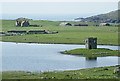
©2009(licence)
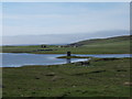
©2009(licence)
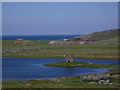
©2008(licence)
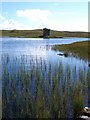
©2010(licence)
©2011(licence)
The above images may not be of the site on this page, they are loaded from Geograph.
Please Submit an Image of this site or go out and take one for us!
Click here to see more info for this site
Nearby sites
Key: Red: member's photo, Blue: 3rd party photo, Yellow: other image, Green: no photo - please go there and take one, Grey: site destroyed
Download sites to:
KML (Google Earth)
GPX (GPS waypoints)
CSV (Garmin/Navman)
CSV (Excel)
To unlock full downloads you need to sign up as a Contributory Member. Otherwise downloads are limited to 50 sites.
Turn off the page maps and other distractions
Nearby sites listing. In the following links * = Image available
3.5km E 96° Airigh Mhic Ruairidh* Stone Fort or Dun (NF76597440)
3.6km E 80° Bac Mhic Connain Ancient Village or Settlement (NF76737537)
3.7km E 83° Geirisclett* Chambered Cairn (NF76847520)
4.0km ENE 68° Bac Mic Connain Stone Fort or Dun (NF76947619)
4.1km SSW 202° Dun Grogary Stone Fort or Dun (NF71257141)
4.1km E 98° Cnoc A'Comhdhalach Ancient Village or Settlement (NF77087415)
4.1km ENE 72° Vallay (N Uist) Rock Art (NF77137600)
4.1km SSE 150° Cleithreabhal* Chambered Cairn (NF749713)
4.1km ESE 116° Buaile Risary Wheelhouse Ancient Village or Settlement (NF76677291)
4.1km ESE 116° Buaile Risary Cup Marked Stone Rock Art (NF76697293)
4.2km E 96° Garry Iochdrach Ancient Village or Settlement (NF77237427)
4.3km SSE 149° South Clettraval* Standing Stone (Menhir) (NF75017118)
4.5km SSE 148° Clettraval South* Burial Chamber or Dolmen (NF75167101)
4.5km E 100° Eilean Maleit Ancient Village or Settlement (NF77487388)
5.6km ENE 73° Rudh' An Duin Stone Fort or Dun (NF7859376180)
6.1km SE 136° Toroghas* Standing Stones (NF77007029)
6.1km ENE 71° Leac nan Cailleacha Dubha Standing Stones (NF79087650)
7.0km E 83° Sollas, Machair Leathann Ancient Village or Settlement (NF80117533)
7.6km E 85° Dun Skellor Broch or Nuraghe (NF80757507)
8.1km SE 132° Bheinn a Charra* Standing Stone (Menhir) (NF7865569075)
8.6km SE 127° Airidhan an t- Sruthain Ghairbh* Chambered Cairn (NF79596937)
8.9km E 86° Dun Toloman Stone Fort or Dun (NF82077492)
9.6km SSE 152° Clach Mhor a' Che* Standing Stone (Menhir) (NF770662)
9.8km ENE 66° Udal (Grenitote)* Ancient Village or Settlement (NF82387822)
10.6km SE 135° Leacach an Tigh Cloiche Standing Stone (Menhir) (NF800669)
View more nearby sites and additional images


 We would like to know more about this location. Please feel free to add a brief description and any relevant information in your own language.
 Wir möchten mehr über diese Stätte erfahren. Bitte zögern Sie nicht, eine kurze Beschreibung und relevante Informationen in Deutsch hinzuzufügen.
 Nous aimerions en savoir encore un peu sur les lieux. S'il vous plaît n'hesitez pas à ajouter une courte description et tous les renseignements pertinents dans votre propre langue.
 Quisieramos informarnos un poco más de las lugares. No dude en añadir una breve descripción y otros datos relevantes en su propio idioma.