 with our Megalithic Portal iPhone app")


<< Our Photo Pages >> House Of The Fairies - Souterrain (Fogou, Earth House) in Scotland in St. Kilda
Submitted by cornishstargazer on Saturday, 14 October 2023 Page Views: 3816
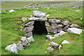
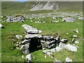
Iron Age and Later PrehistorySite Name: House Of The FairiesCountry: Scotland County: St. Kilda Type: Souterrain (Fogou, Earth House)
Nearest Town: HIrta
Map Ref: NF1001799410
Latitude: 57.813586N Longitude: 8.571319W
Condition:
| 5 | Perfect |
| 4 | Almost Perfect |
| 3 | Reasonable but with some damage |
| 2 | Ruined but still recognisable as an ancient site |
| 1 | Pretty much destroyed, possibly visible as crop marks |
| 0 | No data. |
| -1 | Completely destroyed |
| 5 | Superb |
| 4 | Good |
| 3 | Ordinary |
| 2 | Not Good |
| 1 | Awful |
| 0 | No data. |
| 5 | Can be driven to, probably with disabled access |
| 4 | Short walk on a footpath |
| 3 | Requiring a bit more of a walk |
| 2 | A long walk |
| 1 | In the middle of nowhere, a nightmare to find |
| 0 | No data. |
| 5 | co-ordinates taken by GPS or official recorded co-ordinates |
| 4 | co-ordinates scaled from a detailed map |
| 3 | co-ordinates scaled from a bad map |
| 2 | co-ordinates of the nearest village |
| 1 | co-ordinates of the nearest town |
| 0 | no data |
Internal Links:
External Links:
I have visited· I would like to visit
micske would like to visit
")
Field Visit (22 July 1924)
RCAHMS Inventory: Outer Hebrides, Skye and the Small Isles.
Earth-house, St Kilda.
At the western end of the village of St Kilda the ground rises slightly towards the north, and, at a spot about 100 yards north-west of the township, in close proximity to the present burial ground, an earth-house was accidentally discovered about 1844, and opened and examined in 1876 (1). The internal passage, which measures about 34 feet in length by approximately 4 feet in height and 3 ½ feet broad, is roughly lined with stones of various sizes, apparently unworked. There is one side chamber 6 ft. 2 ins. long and evidence of two others. Here and there undressed roofing slabs of about 8 inches in thickness remain in situ. When disclosed in 1876 the floor was found to be of flat stones with a drain below. It was covered with peat ash and soot in a layer about a foot thick, in which were found bones of animals and sea-fowl, burnt limpet shells, “a large number of rude stone implements resembling hatchets and wedges”, “part of a lamp”, and some fragments of coarse pottery (2). (Figs. 74, 75.)
RCAHMS 1928, visited (by Captain Patrick Grant) 22 July 1924.
(1) See Proc. Soc. Ant. Scot., XII., pp. 186-7; cf. also VII., p. 172.
(2) Mr Sands, who had the place opened in 1876, writes: “The men told me that they had often found small vessels of clay in the earth, but had never seen any pottery made, nor heard that it had ever been made in Hirta. Stone lamps are still to be seen above ground, and some old men told me they had often used them when in Berneray and Soa. It is remarkable that all to whom I showed the implements recognised them at a glance…ʻSean lamhog, sean sgian, old axe, old knife’, they said…It is probable that stone implements were used in St Kilda at a very recent date”. (As cited, p. 187.) Mr R. Kearton says the place “had been only partially explored and to a great extent destroyed”. Among other relics he found an iron spear-head (With Nature and a Camera (1897), p.13.
Source: Canmore: canmore.org.uk/site/9697/st-kilda-hirta-village-bay-house-of-the-fairies
Note: Carolyn K was lucky enough to visit St Kilda recently, also sighting this elusive possible stone circle
You may be viewing yesterday's version of this page. To see the most up to date information please register for a free account.
")
")
")
")
Do not use the above information on other web sites or publications without permission of the contributor.
Nearby Images from Geograph Britain and Ireland:
©2015(licence)
©2021(licence)

©2021(licence)
©2008(licence)
©2011(licence)
The above images may not be of the site on this page, they are loaded from Geograph.
Please Submit an Image of this site or go out and take one for us!
Click here to see more info for this site
Nearby sites
Key: Red: member's photo, Blue: 3rd party photo, Yellow: other image, Green: no photo - please go there and take one, Grey: site destroyed
Download sites to:
KML (Google Earth)
GPX (GPS waypoints)
CSV (Garmin/Navman)
CSV (Excel)
To unlock full downloads you need to sign up as a Contributory Member. Otherwise downloads are limited to 50 sites.
Turn off the page maps and other distractions
Nearby sites listing. In the following links * = Image available
1.2km W 265° Gleann Mor* Standing Stones (NF08869943)
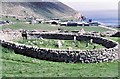
1.4km WNW 294° The Amazon's House (Hirta) Ancient Village or Settlement (NA08780010)
1.6km WNW 296° Tobar nam Buadh (St Kilda) Holy Well or Sacred Spring (NA0864400247)
7.5km NE 36° Boreray* Stone Circle (NA15060499)
67.0km ESE 109° Dun Grogary Stone Fort or Dun (NF71257141)
67.3km ESE 106° Dun Scolpaig* Stone Fort or Dun (NF7310375028)
70.4km ESE 108° Cleithreabhal* Chambered Cairn (NF749713)
70.5km ESE 104° Bac Mic Connain Stone Fort or Dun (NF76947619)
70.5km ESE 108° South Clettraval* Standing Stone (Menhir) (NF75017118)
70.6km ESE 104° Bac Mhic Connain Ancient Village or Settlement (NF76737537)
70.7km ESE 108° Clettraval South* Burial Chamber or Dolmen (NF75167101)
70.8km ESE 104° Geirisclett* Chambered Cairn (NF76847520)
70.8km ESE 104° Vallay (N Uist) Rock Art (NF77137600)
70.8km ESE 105° Airigh Mhic Ruairidh* Stone Fort or Dun (NF76597440)
71.3km ESE 105° Cnoc A'Comhdhalach Ancient Village or Settlement (NF77087415)
71.4km ESE 106° Buaile Risary Wheelhouse Ancient Village or Settlement (NF76677291)
71.4km ESE 106° Buaile Risary Cup Marked Stone Rock Art (NF76697293)
71.4km ESE 105° Garry Iochdrach Ancient Village or Settlement (NF77237427)
71.8km ESE 105° Eilean Maleit Ancient Village or Settlement (NF77487388)
72.1km ESE 103° Rudh' An Duin Stone Fort or Dun (NF7859376180)
72.4km ESE 103° Leac nan Cailleacha Dubha Standing Stones (NF79087650)
72.7km ESE 108° Toroghas* Standing Stones (NF77007029)
73.8km ESE 103° Sollas, Machair Leathann Ancient Village or Settlement (NF80117533)
74.4km ESE 111° Clach Mhor a' Che* Standing Stone (Menhir) (NF770662)
74.5km ESE 103° Dun Skellor Broch or Nuraghe (NF80757507)
View more nearby sites and additional images


 We would like to know more about this location. Please feel free to add a brief description and any relevant information in your own language.
 Wir möchten mehr über diese Stätte erfahren. Bitte zögern Sie nicht, eine kurze Beschreibung und relevante Informationen in Deutsch hinzuzufügen.
 Nous aimerions en savoir encore un peu sur les lieux. S'il vous plaît n'hesitez pas à ajouter une courte description et tous les renseignements pertinents dans votre propre langue.
 Quisieramos informarnos un poco más de las lugares. No dude en añadir una breve descripción y otros datos relevantes en su propio idioma.