Featured: How and why the ancients enchanted Great Britain and Brittany

How and why the ancients enchanted Great Britain and Brittany

Random Image


Westwood Drive 01

Iron Age Britain, Barry Cunliffe

Iron Age Britain, Barry Cunliffe

Who's Online

There are currently, 325 guests and 5 members online.

You are a guest. To join in, please register for free by clicking here

Sponsors

<< Our Photo Pages >> La Varde - Passage Grave in Channel Islands and Isle of Man in Guernsey

Submitted by JJ on Sunday, 11 February 2001  Page Views: 12473

Neolithic and Bronze AgeSite Name: La Varde
Country: Channel Islands and Isle of Man Island: Guernsey Type: Passage Grave
Nearest Town: St Peter Port  Nearest Village: Vale
Map Ref: WV337836
Latitude: 49.502153N  Longitude: 2.535948W
Condition:
5Perfect
4Almost Perfect
3Reasonable but with some damage
2Ruined but still recognisable as an ancient site
1Pretty much destroyed, possibly visible as crop marks
0No data.
-1Completely destroyed
4 Ambience:
5Superb
4Good
3Ordinary
2Not Good
1Awful
0No data.
4 Access:
5Can be driven to, probably with disabled access
4Short walk on a footpath
3Requiring a bit more of a walk
2A long walk
1In the middle of nowhere, a nightmare to find
0No data.
4 Accuracy:
5co-ordinates taken by GPS or official recorded co-ordinates
4co-ordinates scaled from a detailed map
3co-ordinates scaled from a bad map
2co-ordinates of the nearest village
1co-ordinates of the nearest town
0no data
4

Internal Links:
External Links:

La Varde
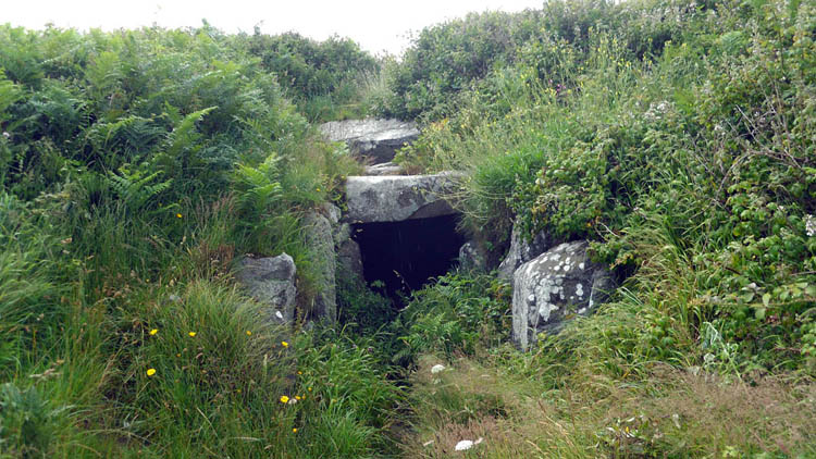
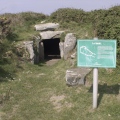
La Varde submitted by shamrockstone : Coordinates are: 49.502266N, 2.536316W Condition: 5 Ambience: 5 Access: 4 Accuracy: 5 (Vote or comment on this photo)
This is the largest megalithic structure surviving on the island of Guernsey. The round mound is 18 meters in diameter, and the largest capstone weighs over ten tons!

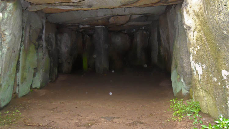
Like Le Trepied and Le Creux es Faies the interior is a bottle shape with no side chambers to speak of.

Access: Perry's guide map square 6B2
You may be viewing yesterday's version of this page. To see the most up to date information please register for a free account.

La Varde
La Varde submitted by ShamrockStone : La Varde Passage Grave, Guernsey. (Vote or comment on this photo)

La Varde
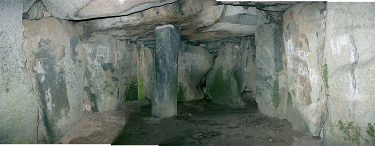
La Varde submitted by stone_de_croze : Here is a photomontage made from three wide angle pictures of the interior of Guernsey's largest surviving dolmen. (8 comments - Vote or comment on this photo)

La Varde
La Varde submitted by Tom_Bullock : Photo used by kind permission of Tom Bullock. More details of this location are to be found on his Stone Circles and Rows CD-ROM (Vote or comment on this photo)

La Varde
La Varde submitted by shamrockstone : Inside La Varde (Vote or comment on this photo)

La Varde
La Varde submitted by stone_de_croze : Early 1900's postcard of La Varde.

La Varde
La Varde submitted by Tom_Bullock : Photo used by kind permission of Tom Bullock. More details of this location are to be found on his Stone Circles and Rows CD-ROM

La Varde
La Varde submitted by karolus : Arguably a large Goddess face set in a vesica shaped hollow on the third capstone in. Only just noticed it this year after 20 years of coming here. Oddly the bas-relief "veins" run out to the edges of the rock, creating a classic "odal" rune form, the rune for Mother Earth. This is on the only pink granite capstone, and visible by squatting down and looking up by the 1898 stabilizing pillar. (2 comments)

La Varde
La Varde submitted by durhamnature : Photo from "Guernsey Folklore" via archive.org

La Varde
La Varde submitted by stone_de_croze : Early 1900s card. The fencing that once surrounded the site is long gone. (4 comments)

La Varde
La Varde submitted by Tom_Bullock : Photo used by kind permission of Tom Bullock. More details of this location are to be found on his Stone Circles and Rows CD-ROM

Do not use the above information on other web sites or publications without permission of the contributor.
Click here to see more info for this site

Nearby sites

Click here to view sites on an interactive map of the area

Key: Red: member's photo, Blue: 3rd party photo, Yellow: other image, Green: no photo - please go there and take one, Grey: site destroyed

Download sites to:
KML (Google Earth)
GPX (GPS waypoints)
CSV (Garmin/Navman)
CSV (Excel)

To unlock full downloads you need to sign up as a Contributory Member. Otherwise downloads are limited to 50 sites.

Megalithic Mysteries by Andy Burnham


Turn off the page maps and other distractions

Nearby sites listing. In the following links * = Image available
 290m ESE 105° La Mare es Mauves* Burial Chamber or Dolmen
 367m E 97° Martello 7* Stone Circle
 465m SSW 193° La Platte Mare* Burial Chamber or Dolmen
 536m SSW 194° Les Fouaillages* Burial Chamber or Dolmen
 1.1km SSW 195° St Michel Du Valle* Not Known (by us)
 1.4km WSW 254° Rousse Cists* Cist
 1.6km SSW 209° Sandy Lane* Burial Chamber or Dolmen
 1.6km SSW 203° L'Islet* Burial Chamber or Dolmen
 1.8km SE 135° La Roque qui Sonne* Passage Grave
 2.2km ESE 105° Le Dehus* Burial Chamber or Dolmen
 2.4km S 176° Route St Clair* Standing Stone (Menhir) (WV339812)
 2.7km SSE 168° La Pointue Rocque* Standing Stone (Menhir)
 2.8km SSE 161° Delancey* Burial Chamber or Dolmen (WV346810)
 3.2km WSW 244° Port Soif Dolmen* Burial Chamber or Dolmen
 3.4km S 183° Le Chateau Du Marais* Artificial Mound
 4.7km S 185° La Petite L'Hyvreuse Passage Grave
 4.9km S 186° La Pierre de L'Hyvreuse Standing Stone (Menhir)
 4.9km SSW 192° Courtil D'Ydol de St Jacques Standing Stone (Menhir)
 4.9km SSW 197° La Grande Pouquelaye Passage Grave
 5.2km SSW 192° La Petite Longue Rocque des Granges* Standing Stone (Menhir) (WV326785)
 5.5km SSW 209° Castel (Guernsey)* Standing Stone (Menhir) (WV311788)
 5.5km S 173° Guernsey Maritime Museum Museum
 6.5km ESE 115° Petit Monceau* Burial Chamber or Dolmen
 6.6km ESE 113° The Common (Herm)* Burial Chamber or Dolmen
 6.6km ESE 115° Robert's Cross* Burial Chamber or Dolmen
View more nearby sites and additional images

<< Ardgroom Stone Circle

Island (Cork) >>

Please add your thoughts on this site

The Singing Neanderthals: The Origins of Music, Language, Mind and Body

The Singing Neanderthals: The Origins of Music, Language, Mind and Body

Web Links for La Varde

Megalithic Mysteries by Andy Burnham

Sponsors

Auto-Translation (Google)

Translate from English into:

"La Varde" | Login/Create an Account | 3 News and Comments
  
Go back to top of page    Comments are owned by the poster. We aren't responsible for their content.
Re: La Varde by ShamrockStone on Thursday, 12 July 2012
(User Info | Send a Message)
Coordinates are: 49.502266N, 2.536316W, taken by GPS
[ Reply to This ]

Re: La Varde by rogeralbin on Saturday, 09 October 2010
(User Info | Send a Message)
The most striking thing to me about this site is that the supporting stone directly opposite the entrance, the focal point of the monument with the small antechamber at the rear is vaguely triangular. To those unfamiliar with the island of Guernsey on the map it has a triangular shape and this stone looks like a representation of of a map of the island, unfortunately the above images do not show the entire stone face on, although one of the images does display it at an angle. Very profound, l could not quite take it in at first surely it cannot be coincedental.
[ Reply to This ]

Re: La Varde by Stone_de_Croze on Wednesday, 10 May 2006
(User Info | Send a Message)
La Rocque Qui Sonne may have been the largest monument if it had survived, but that dolmen didn’t have the fortune of being filled and buried with sand for many years like La Varde. Rediscovered in 1811 by soldiers of the regiment of the Duc De Montemar who were in Guernsey stationed on this hill. While raising a rampart around their camp using the grass turf, they exposed the capstones. Sir John Doyle, the Governor sent a party to excavate but for safety reasons stopped the exploration. During the summers of 1837-38 La Varde was thoroughly explored by the Lukis family. Full of sand, the grave revealed burials in at least two phases separated by a layer of limpet shells and pebbles. They also found many bones, some of children and some cremated remains in the lower of the two layers. Bones and skull fragments where found between the uprights and many (over 150) pottery jars where also unearthed.

Ferdinand Brock Tupper wrote his 1854 History of Guernsey and its Bailiwick (p 392)

“Cromlech at L’Ancresse – In the year 1811, a large cromlech was accidentally discovered, completely buried with drift sand, on an eminence near the beach at L’Ancresse, in Guernsey: it is 45 feet in length by 15 feet in width, and nearly 8 feet in height within the area at the western end, whence it gradually contracts on each side and at the top, near the eastern end. This space is covered by five larger and two smaller blocks of granite, which are not in contact: the western block is computed to weigh about thirty tons, it being nearly 17 feet long, 10 1?2 wide and 4 1?2 thick; and it was probably placed there by means of rollers. The second block is 16 feet long, the third smaller, and so they gradually diminish until the seventh. This fine cromlech was left filled and most imperfectly explored until the year 1837, when, after considerable labour, it was cleared of sand, and its primaeval contents exposed, at the expense and through the antiquarian zeal of F. C. Lukis, Esq. before mentioned.

On the floor were then found two layers consisting of human bones, urns of coarse red and black clay, stone and clay amulets and beads, bone pins, &c., the layers, like those of cists, being separated by flat fragments of granite: the lower stratum was laid in a rude pavement on the natural soil. The remains were deposited in a singular manner: the unburnt bones occupied either end of the floor, the middle third being allotted to those which had been submitted to the action of fire; not a vestige of charcoal was to be detected with them. The bones of individual skeletons where heaped together confusedly, and each heap surrounded by a ring of round flat pebbles; the urns, which were of remarkably rude shape and material, being near or within the rings. Some heaps consisted, as it were, of parent’s and children’s ashes mingled together, for within the same ring of pebbles were the bones of persons of al ages: an unusual quantity of bones of very young children were found. The lower stratum only contained the burnt bones, among which likewise a few tusks of the boar, perhaps worn as trophies of the chase, and consigned to the fire with the dead hunter’s body.

Four flat discs, from six to twelve inches in diameter and one in thickness, and formed the same ware as the urns, were also found, and doubtless served as lids to some of the urns, which had broad flat edges: as these lids are furnished with central handles, it may be inferred that the urns where replenished from time to time, the cromlech being a hollow vault or catacomb. In no instance was the urn used to contain the ashes of the dead, and it was doubtless filled with liquid or food – some where quite entire, and of those broken many had been restored. As time and ages elapsed, and, possibly, as all memory of the departed became lost, their remains were removed to make room for others; those so removed were placed in the interval between the props, and were lost to site; but further space being again required, many cart l

Read the rest of this post...
[ Reply to This ]

Your Name: Anonymous [ Register Now ]
Subject:


Add your comment or contribution to this page. Spam or offensive posts are deleted immediately, don't even bother

<<< What is five plus one as a number? (Please type the answer to this question in the little box on the left)
You can also embed videos and other things. For Youtube please copy and paste the 'embed code'.
For Google Street View please include Street View in the text.
Create a web link like this: <a href="https://www.megalithic.co.uk">This is a link</a>  

Allowed HTML is:
<p> <b> <i> <a> <img> <em> <br> <strong> <blockquote> <tt> <li> <ol> <ul> <object> <param> <embed> <iframe>

We would like to know more about this location. Please feel free to add a brief description and any relevant information in your own language.
Wir möchten mehr über diese Stätte erfahren. Bitte zögern Sie nicht, eine kurze Beschreibung und relevante Informationen in Deutsch hinzuzufügen.
Nous aimerions en savoir encore un peu sur les lieux. S'il vous plaît n'hesitez pas à ajouter une courte description et tous les renseignements pertinents dans votre propre langue.
Quisieramos informarnos un poco más de las lugares. No dude en añadir una breve descripción y otros datos relevantes en su propio idioma.