<< Our Photo Pages >> Guinivrit - Passage Grave in France in Bretagne:Finistère (29)
Submitted by TheCaptain on Friday, 13 July 2012 Page Views: 10353
Neolithic and Bronze AgeSite Name: Guinivrit Alternative Name: Porz Meur allée couverte, Kernic allée couverteCountry: France Département: Bretagne:Finistère (29) Type: Passage Grave
Nearest Town: Saint-Pol-de-Léon Nearest Village: Plouescat
Latitude: 48.656800N Longitude: 4.2159W
Condition:
| 5 | Perfect |
| 4 | Almost Perfect |
| 3 | Reasonable but with some damage |
| 2 | Ruined but still recognisable as an ancient site |
| 1 | Pretty much destroyed, possibly visible as crop marks |
| 0 | No data. |
| -1 | Completely destroyed |
| 5 | Superb |
| 4 | Good |
| 3 | Ordinary |
| 2 | Not Good |
| 1 | Awful |
| 0 | No data. |
| 5 | Can be driven to, probably with disabled access |
| 4 | Short walk on a footpath |
| 3 | Requiring a bit more of a walk |
| 2 | A long walk |
| 1 | In the middle of nowhere, a nightmare to find |
| 0 | No data. |
| 5 | co-ordinates taken by GPS or official recorded co-ordinates |
| 4 | co-ordinates scaled from a detailed map |
| 3 | co-ordinates scaled from a bad map |
| 2 | co-ordinates of the nearest village |
| 1 | co-ordinates of the nearest town |
| 0 | no data |
Internal Links:
External Links:
I have visited· I would like to visit
PAB DrewParsons would like to visit
43559959 visited on 26th Apr 2014 - their rating: Cond: 5 Amb: 4 Access: 4
TheCaptain saw from a distance on 16th Apr 2014 Seen from over the estuary from the south, tide out and on the sandy beach.
bunnymadcaz visited on 5th Aug 2011 - their rating: Cond: 3 Amb: 4 Access: 4 Lovely gellery grave that gets covered by the tide at high tide!
TheCaptain visited on 21st Jun 2005 - their rating: Cond: 3 Amb: 4 Access: 4 This really is a nice place to visit, certainly when its quiet and the sun is out. I had hoped to see it with the tide well in tonight, but one thing and another and its now gone 8:00, and the tide is already gone out for two hours, and the water has gone from around it. However, there is still a lot of water flooding out of the bay, and I certainly wouldn't want to try and get a boat in here, as its going at running speed.
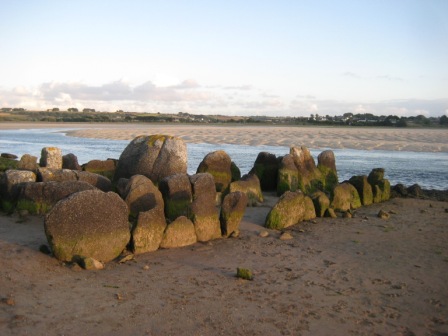
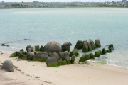
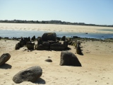
The allée couverte is easily found down beside the little harbour, and nowadays is signposted. Its not far at all from the little campsite where I stayed. Despite the fact that it has no capstones, and that some of the large side stones have been broken so it could act as a mole in the water for mooring and protecting boats in the past, it really is surprisingly complete. Most of the stones are still in place, not only of the main chamber, but also the peristalith, which is suitably boat shaped. In fact the whole thing looks rather like a boat pulled up onto the shoreline.
The main chamber is about eleven metres long and 1.5 metres in width, but with the outer stones the full size of the monument is more than double that, perhaps 30 metres by 6 metres. There is both a forward and aft extension to the compartmentalised chamber. Fantastic.
While here, I met a chap out for a bike ride, and we got talking about why I was here and ancient stones. He said he has always lived in the area, and as a boy used to play in the Goazvenn dolmen. He went on to tell me about a large fallen menhir that is almost forgotten, and that nobody ever talks about, and which seems to be in no historical records. He told me how to find it by walking around the coast path, and showed me where it was on my map, fallen onto the rocky shore. I decided that this was one place I had to visit, finding these forgotten stones has much more of a thrill than seeing the well known ones.
Martin_L have visited here
Average ratings for this site from all visit loggers: Condition: 3.67 Ambience: 4 Access: 4
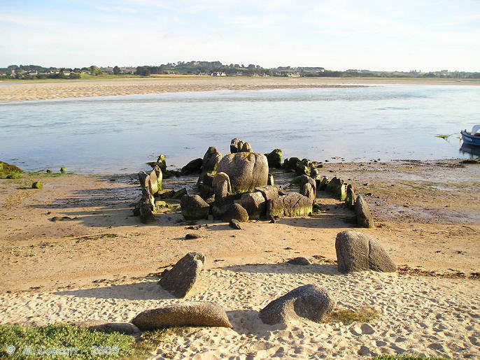
This really is a nice place to visit, certainly when its quiet and the sun is out. I had hoped to see it with the tide well in tonight, but one thing and another and its now gone 8:00, and the tide is already gone out for two hours, and the water has gone from around it. However, there is still a lot of water flooding out of the bay, and I certainly wouldnt want to try and get a boat in here, as its going at running speed.
The allée couverte is easily found down beside the little harbour, and nowadays is signposted. Its not far at all from the little campsite where I stayed. Despite the fact that it has no capstones, and that some of the large side stones have been broken so it could act as a mole in the water for mooring and protecting boats in the past, it really is surprisingly complete.
Most of the stones are still in place, not only of the main chamber, but also the peristalith, which is suitably boat shaped. In fact the whole thing looks rather like a boat pulled up onto the shoreline.
The main chamber is about eleven metres long and 1.5 metres in width, but with the outer stones the full size of the monument is more than double that, perhaps 30 metres by 6 metres. There is both a forward and aft extension to the compartmentalised chamber.
Fantastic
Note: new photos and description added
You may be viewing yesterday's version of this page. To see the most up to date information please register for a free account.






Do not use the above information on other web sites or publications without permission of the contributor.
Click here to see more info for this site
Nearby sites
Click here to view sites on an interactive map of the areaKey: Red: member's photo, Blue: 3rd party photo, Yellow: other image, Green: no photo - please go there and take one, Grey: site destroyed
Download sites to:
KML (Google Earth)
GPX (GPS waypoints)
CSV (Garmin/Navman)
CSV (Excel)
To unlock full downloads you need to sign up as a Contributory Member. Otherwise downloads are limited to 50 sites.
Turn off the page maps and other distractions
Nearby sites listing. In the following links * = Image available
1.1km SSW 196° Menhir de Kernic Standing Stone (Menhir)
1.2km ENE 61° Prat Meur menhir* Standing Stone (Menhir)
1.3km NNE 24° Porz Ar Stréat menhir* Standing Stone (Menhir)
1.8km SW 224° Stèle dite Ar Groaz Standing Stone (Menhir)
2.1km SSW 196° Calvaire de Menez-ar-Plour Standing Stone (Menhir)
2.1km SW 216° Menhir de Brétouaré 1 Standing Stone (Menhir)
2.4km SSW 212° Dolmen de Brétouaré Burial Chamber or Dolmen
2.4km SSW 209° Menhir de Brétouaré 2 Standing Stone (Menhir)
3.4km NNE 33° Grand menhir de Saint-Eden* Standing Stone (Menhir)
4.0km NE 36° Menhir de Kergoarat* Standing Stone (Menhir)
4.2km E 89° Couinandré Menhir* Standing Stone (Menhir)
4.3km E 90° Créac’h-ar-Vrenn* Passage Grave
4.4km S 176° Parc Ar ouest menhir Standing Stone (Menhir)
4.4km S 176° Parc Ar est menhir Standing Stone (Menhir)
4.5km ENE 57° Menhir d'Irvit* Standing Stone (Menhir)
4.9km ENE 66° Menhir de Kergallec Standing Stone (Menhir)
5.5km E 85° Kerider stèle* Standing Stone (Menhir)
5.9km SSE 163° Landeguiarc'h menhir Standing Stone (Menhir)
6.8km SW 235° Créac'h Gallic* Passage Grave
7.1km W 268° Diévet Dolmen* Burial Chamber or Dolmen
7.5km WSW 244° Fontaine de St Goulven* Holy Well or Sacred Spring
8.0km W 269° Menoignon menhir* Standing Stone (Menhir)
8.9km W 280° Men-Marz* Standing Stone (Menhir)
9.8km ENE 68° Affleurement à Cupules de Creach al Lia Rock Art
10.3km WSW 250° Dolmen de Kerbervas* Burial Chamber or Dolmen
View more nearby sites and additional images


 We would like to know more about this location. Please feel free to add a brief description and any relevant information in your own language.
 Wir möchten mehr über diese Stätte erfahren. Bitte zögern Sie nicht, eine kurze Beschreibung und relevante Informationen in Deutsch hinzuzufügen.
 Nous aimerions en savoir encore un peu sur les lieux. S'il vous plaît n'hesitez pas à ajouter une courte description et tous les renseignements pertinents dans votre propre langue.
 Quisieramos informarnos un poco más de las lugares. No dude en añadir una breve descripción y otros datos relevantes en su propio idioma.