

<< Our Photo Pages >> Moel Goedog 4 - Standing Stone (Menhir) in Wales in Gwynedd
Submitted by PaulM on Sunday, 28 November 2004 Page Views: 5776
Neolithic and Bronze AgeSite Name: Moel Goedog 4Country: Wales County: Gwynedd Type: Standing Stone (Menhir)
Nearest Town: Harlech Nearest Village: Eisingrug
Map Ref: SH60893216 Landranger Map Number: 124
Latitude: 52.868883N Longitude: 4.068103W
Condition:
| 5 | Perfect |
| 4 | Almost Perfect |
| 3 | Reasonable but with some damage |
| 2 | Ruined but still recognisable as an ancient site |
| 1 | Pretty much destroyed, possibly visible as crop marks |
| 0 | No data. |
| -1 | Completely destroyed |
| 5 | Superb |
| 4 | Good |
| 3 | Ordinary |
| 2 | Not Good |
| 1 | Awful |
| 0 | No data. |
| 5 | Can be driven to, probably with disabled access |
| 4 | Short walk on a footpath |
| 3 | Requiring a bit more of a walk |
| 2 | A long walk |
| 1 | In the middle of nowhere, a nightmare to find |
| 0 | No data. |
| 5 | co-ordinates taken by GPS or official recorded co-ordinates |
| 4 | co-ordinates scaled from a detailed map |
| 3 | co-ordinates scaled from a bad map |
| 2 | co-ordinates of the nearest village |
| 1 | co-ordinates of the nearest town |
| 0 | no data |
Internal Links:
External Links:
I have visited· I would like to visit
Catrinm visited on 11th Apr 2019 - their rating: Cond: 3 Amb: 3 Access: 4
Catrinm visited on 11th Apr 2019 - their rating: Cond: 3 Amb: 3 Access: 4
TheCaptain hamish have visited here
Average ratings for this site from all visit loggers: Condition: 3 Ambience: 3 Access: 4
")
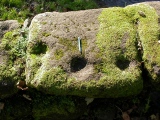
The short pointy Moel Goedog 4 can be found to the SE of the path.
From Coflein
This complex of standing stones is a Scheduled Ancient Monument. They mark out a suggested prehistoric trackway leading along the lower slopes of Moel Goedog.
Update November 2019: The Stone Rows of Great Britain discusses the possibility of the nine standing stones at Moel Goedog making up a single stone row measuring 1,898 metres long, standing on a prominent ridge overlooking the sea. Their entry for Fonllech includes a description, a plan of the row from a survey carried out in August 2018, photographs of all the stones in the alignment, access information and a list of online resources for more information. The SRoGB also includes a section discussing the interpretation of this monument.
For information about the other stones in this probably alignment, see the individual site pages for Moel Goedog 1 to Moel Goedog 9 inclusive, plus the Moel Goedog E ring cairn.
You may be viewing yesterday's version of this page. To see the most up to date information please register for a free account.
")
")
")
")
")
Do not use the above information on other web sites or publications without permission of the contributor.
Nearby sites
Download sites to:
KML (Google Earth)
GPX (GPS waypoints)
CSV (Garmin/Navman)
CSV (Excel)
To unlock full downloads you need to sign up as a Contributory Member. Otherwise downloads are limited to 50 sites.
Nearby sites listing. In the following links * = Image available
73m NNW 336° Moel Goedog 9* Standing Stone (Menhir) (SH6086232228)
80m W 268° Moel Goedog 3* Standing Stone (Menhir) (SH60813216)
139m NNE 19° Moel Goedog 5* Standing Stone (Menhir) (SH60943229)
213m ENE 78° Hut Circle SW Moel Goedog* Ancient Village or Settlement (SH611322)
216m SW 235° Moel Goedog 2* Standing Stone (Menhir) (SH60713204)
255m WSW 238° Moel Goedog 1* Standing Stone (Menhir) (SH60673203)
293m WNW 304° Erw Wen* Ancient Village or Settlement (SH60653233)
317m NNE 19° Moel Goedog W* Ring Cairn (SH6100332456)
322m NNE 28° Moel Goedog E* Ring Cairn (SH61053244)
385m ENE 67° Hut Circle and Enclosure E of Erw Wen* Ancient Village or Settlement (SH61253230)
459m WNW 296° Massive walled Hut circle associated with field system near Erw Wen* Ancient Village or Settlement (SH6048032370)
593m NE 52° Moel Goedog Hillfort* Hillfort (SH61373251)
611m E 94° Settlement 400m SE of Moel Goedog* Ancient Village or Settlement (SH615321)
671m SW 221° Moel Goedog 6* Standing Stone (Menhir) (SH60433167)
810m E 93° Settlement 500m SE of Moel Goedog* Ancient Village or Settlement (SH617321)
1.0km NNE 32° Tyddyn Sion Wyn* Ring Cairn (SH61453300)
1.0km NE 42° Ffridd Fedw* Ancient Village or Settlement (SH616329)
1.1km SSE 157° Bedd Gorfal* Stone Circle (SH61293114)
1.1km SSE 152° Hut Circle and Enclosure, Moel y Gerddi* Ancient Village or Settlement (SH6138031160)
1.1km SW 220° Moel Goedog 7* Standing Stone (Menhir) (SH60133130)
1.2km ENE 59° Moel Goedog Hut Circle* Ancient Village or Settlement (SH6193732739)
1.2km SSE 168° Hut Circle West of Gerddi Bluog* Ancient Village or Settlement (SH61123094)
1.5km SSE 160° Moel y Gerddi Hut Circles and Enclosure* Ancient Village or Settlement (SH61383069)
1.6km SW 217° Garreg round cairn* Round Cairn (SH59913095)
1.6km SW 219° Moel Goedog 8* Standing Stone (Menhir) (SH59883097)


 We would like to know more about this location. Please feel free to add a brief description and any relevant information in your own language.
 Wir möchten mehr über diese Stätte erfahren. Bitte zögern Sie nicht, eine kurze Beschreibung und relevante Informationen in Deutsch hinzuzufügen.
 Nous aimerions en savoir encore un peu sur les lieux. S'il vous plaît n'hesitez pas à ajouter une courte description et tous les renseignements pertinents dans votre propre langue.
 Quisieramos informarnos un poco más de las lugares. No dude en añadir una breve descripción y otros datos relevantes en su propio idioma.