


<< Our Photo Pages >> Frank i’ th’ Rocks Cave - Cave or Rock Shelter in England in Derbyshire
Submitted by vicky on Sunday, 18 May 2003 Page Views: 9738
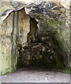
Natural PlacesSite Name: Frank i’ th’ Rocks CaveCountry: England County: Derbyshire Type: Cave or Rock Shelter
Map Ref: SK1313558408 Landranger Map Number: 119
Latitude: 53.122685N Longitude: 1.80518W
Condition:
| 5 | Perfect |
| 4 | Almost Perfect |
| 3 | Reasonable but with some damage |
| 2 | Ruined but still recognisable as an ancient site |
| 1 | Pretty much destroyed, possibly visible as crop marks |
| 0 | No data. |
| -1 | Completely destroyed |
| 5 | Superb |
| 4 | Good |
| 3 | Ordinary |
| 2 | Not Good |
| 1 | Awful |
| 0 | No data. |
| 5 | Can be driven to, probably with disabled access |
| 4 | Short walk on a footpath |
| 3 | Requiring a bit more of a walk |
| 2 | A long walk |
| 1 | In the middle of nowhere, a nightmare to find |
| 0 | No data. |
| 5 | co-ordinates taken by GPS or official recorded co-ordinates |
| 4 | co-ordinates scaled from a detailed map |
| 3 | co-ordinates scaled from a bad map |
| 2 | co-ordinates of the nearest village |
| 1 | co-ordinates of the nearest town |
| 0 | no data |
Internal Links:
External Links:
I have visited· I would like to visit
Couplands visited on 17th Sep 2022 - their rating: Amb: 4 Access: 2
elad13 visited on 18th Aug 2018 - their rating: Cond: 5 Amb: 4 Access: 3
Average ratings for this site from all visit loggers: Ambience: 4 Access: 2.5
")
Have you visited this site? Please add a comment below.
You may be viewing yesterday's version of this page. To see the most up to date information please register for a free account.
")
Do not use the above information on other web sites or publications without permission of the contributor.
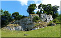
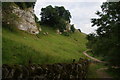
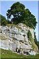
Nearby Images from Geograph Britain and Ireland:
©2016(licence)
©2016(licence)
©2013(licence)
©2012(licence)
©2016(licence)
The above images may not be of the site on this page, they are loaded from Geograph.
Please Submit an Image of this site or go out and take one for us!
Click here to see more info for this site
Nearby sites
Key: Red: member's photo, Blue: 3rd party photo, Yellow: other image, Green: no photo - please go there and take one, Grey: site destroyed
Download sites to:
KML (Google Earth)
GPX (GPS waypoints)
CSV (Garmin/Navman)
CSV (Excel)
To unlock full downloads you need to sign up as a Contributory Member. Otherwise downloads are limited to 50 sites.
Turn off the page maps and other distractions
Nearby sites listing. In the following links * = Image available
1.3km S 177° Gratton Hill* Round Barrow(s) (SK13205715)
1.8km NE 46° Dale End* Modern Stone Circle etc (SK14455970)
1.9km S 181° Pea Low* Chambered Cairn (SK131565)
2.3km ESE 108° Liffs Low* Round Barrow(s) (SK153577)
2.3km SE 141° Stoney Low Round Barrow(s) (SK146566)
2.6km W 279° Archford Moor Barrow* Round Barrow(s) (SK106588)
2.6km SW 225° Gateham Grange* Round Barrow(s) (SK11305659)
3.0km NW 312° Town End Barrow Round Barrow(s) (SK109604)
3.1km SE 138° Nettly Knowe* Round Barrow(s) (SK15225610)
3.1km S 179° Alstonefield Cross* Ancient Cross (SK132553)
3.2km WSW 244° Sycamore Cave Ecton Cave or Rock Shelter (SK102570)
3.3km NE 48° End Low* Round Barrow(s) (SK156606)
3.5km SW 231° Wetton Hill* Round Barrow(s) (SK104562)
3.6km SSE 147° Green Low (Alsop)* Round Barrow(s) (SK151554)
3.7km W 276° The Cops* Round Barrow(s) (SK0944358817)
3.7km NNE 32° Moneystones* Round Barrow(s) (SK151616)
3.9km NW 318° Rye Low* Round Barrow(s) (SK105613)
4.0km SE 135° Cross Low 2* Round Barrow(s) (SK15965561)
4.1km W 270° Warslow Bowl Barrow* Round Barrow(s) (SK09075837)
4.1km E 100° Parwich Ring Cairn (SK172577)
4.1km SW 236° Mill Pot Cave Cave or Rock Shelter (SK097561)
4.1km SSW 206° Wetton Low* Round Barrow(s) (SK113547)
4.1km N 351° Lud well (Hartington)* Holy Well or Sacred Spring (SK125625)
4.2km SW 233° Darfar Ridge Cave Cave or Rock Shelter (SK098559)
4.2km NNE 25° Lean Low* Round Barrow(s) (SK149622)
View more nearby sites and additional images


 We would like to know more about this location. Please feel free to add a brief description and any relevant information in your own language.
 Wir möchten mehr über diese Stätte erfahren. Bitte zögern Sie nicht, eine kurze Beschreibung und relevante Informationen in Deutsch hinzuzufügen.
 Nous aimerions en savoir encore un peu sur les lieux. S'il vous plaît n'hesitez pas à ajouter une courte description et tous les renseignements pertinents dans votre propre langue.
 Quisieramos informarnos un poco más de las lugares. No dude en añadir una breve descripción y otros datos relevantes en su propio idioma.