

<< Text Pages >> Fuente de las Yegas 1 - Burial Chamber or Dolmen in Spain in Extremadura
Submitted by TheCaptain on Wednesday, 08 September 2010 Page Views: 1645
Neolithic and Bronze AgeSite Name: Fuente de las Yegas 1Country: Spain Region: Extremadura Type: Burial Chamber or Dolmen
Nearest Town: Caceres Nearest Village: Valencia de Alcantara
Latitude: 39.416000N Longitude: 7.233W
Condition:
| 5 | Perfect |
| 4 | Almost Perfect |
| 3 | Reasonable but with some damage |
| 2 | Ruined but still recognisable as an ancient site |
| 1 | Pretty much destroyed, possibly visible as crop marks |
| 0 | No data. |
| -1 | Completely destroyed |
| 5 | Superb |
| 4 | Good |
| 3 | Ordinary |
| 2 | Not Good |
| 1 | Awful |
| 0 | No data. |
| 5 | Can be driven to, probably with disabled access |
| 4 | Short walk on a footpath |
| 3 | Requiring a bit more of a walk |
| 2 | A long walk |
| 1 | In the middle of nowhere, a nightmare to find |
| 0 | No data. |
| 5 | co-ordinates taken by GPS or official recorded co-ordinates |
| 4 | co-ordinates scaled from a detailed map |
| 3 | co-ordinates scaled from a bad map |
| 2 | co-ordinates of the nearest village |
| 1 | co-ordinates of the nearest town |
| 0 | no data |
Be the first person to rate this site - see the 'Contribute!' box in the right hand menu.
Internal Links:
External Links:
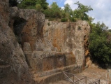
Burial chamber in Extremadura
Fuente de las Yegas 1 is a burial chamber in the community of Valencia de Alcantara, Province of Caceres, region of Extremadura
You may be viewing yesterday's version of this page. To see the most up to date information please register for a free account.
Do not use the above information on other web sites or publications without permission of the contributor.
Nearby Images from Flickr
The above images may not be of the site on this page, but were taken nearby. They are loaded from Flickr so please click on them for image credits.
Click here to see more info for this site
Nearby sites
Click here to view sites on an interactive map of the areaKey: Red: member's photo, Blue: 3rd party photo, Yellow: other image, Green: no photo - please go there and take one, Grey: site destroyed
Download sites to:
KML (Google Earth)
GPX (GPS waypoints)
CSV (Garmin/Navman)
CSV (Excel)
To unlock full downloads you need to sign up as a Contributory Member. Otherwise downloads are limited to 50 sites.
Turn off the page maps and other distractions
Nearby sites listing. In the following links * = Image available
nankm 0° Cortinal Burial Chamber or Dolmen
86m W 270° Cachazo Burial Chamber or Dolmen
86m W 270° Fuente de las Yegas 2 Burial Chamber or Dolmen
86m E 90° Fraguil Burial Chamber or Dolmen
111m S 180° La Vihuela 1 Burial Chamber or Dolmen
111m N 0° Anta de la Marquesa Burial Chamber or Dolmen
141m NW 322° Asiento Burial Chamber or Dolmen
141m SW 218° La Vihuela 2 Burial Chamber or Dolmen
141m NE 38° Chaves Burial Chamber or Dolmen
205m ENE 57° Martinez Burial Chamber or Dolmen
205m WNW 303° Torre Albarragena Burial Chamber or Dolmen
222m N 0° El Retamar Burial Chamber or Dolmen
238m NNW 339° Cancho del Lobo Burial Chamber or Dolmen
281m WNW 293° Torrejon el Rubio Burial Chamber or Dolmen
281m WNW 293° Cancho Panedo Castro or Chafurdão
334m N 0° La Cotadilla 3 Burial Chamber or Dolmen
344m NNW 346° La Cotadilla 4 Burial Chamber or Dolmen
344m NNE 14° La Cotadilla 2 Burial Chamber or Dolmen
375m NNE 27° La Cotadilla 1 Burial Chamber or Dolmen
1.3km SSE 147° Zafra Dolmen 1* Burial Chamber or Dolmen
1.5km SE 138° Zafra Dolmen 2* Burial Chamber or Dolmen
1.7km SE 128° Zafra Dolmen 5 Burial Chamber or Dolmen
1.9km SSE 150° Zafra Dolmen 3* Burial Chamber or Dolmen
2.1km SSE 153° Zafra Dolmen 4* Burial Chamber or Dolmen
2.3km SE 125° Tapias 1* Burial Chamber or Dolmen
View more nearby sites and additional images


 We would like to know more about this location. Please feel free to add a brief description and any relevant information in your own language.
 Wir möchten mehr über diese Stätte erfahren. Bitte zögern Sie nicht, eine kurze Beschreibung und relevante Informationen in Deutsch hinzuzufügen.
 Nous aimerions en savoir encore un peu sur les lieux. S'il vous plaît n'hesitez pas à ajouter une courte description et tous les renseignements pertinents dans votre propre langue.
 Quisieramos informarnos un poco más de las lugares. No dude en añadir una breve descripción y otros datos relevantes en su propio idioma.