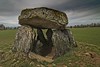
<< Our Photo Pages >> Betoulle dolmen 4 - Burial Chamber or Dolmen in France in Limousin:Haute-Vienne (87)
Submitted by TheCaptain on Saturday, 16 April 2005 Page Views: 2974
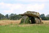
Neolithic and Bronze AgeSite Name: Betoulle dolmen 4Country: France Département: Limousin:Haute-Vienne (87) Type: Burial Chamber or Dolmen
Nearest Town: Limoges Nearest Village: Breuilaufa
Latitude: 46.049300N Longitude: 1.111400E
Condition:
| 5 | Perfect |
| 4 | Almost Perfect |
| 3 | Reasonable but with some damage |
| 2 | Ruined but still recognisable as an ancient site |
| 1 | Pretty much destroyed, possibly visible as crop marks |
| 0 | No data. |
| -1 | Completely destroyed |
| 5 | Superb |
| 4 | Good |
| 3 | Ordinary |
| 2 | Not Good |
| 1 | Awful |
| 0 | No data. |
| 5 | Can be driven to, probably with disabled access |
| 4 | Short walk on a footpath |
| 3 | Requiring a bit more of a walk |
| 2 | A long walk |
| 1 | In the middle of nowhere, a nightmare to find |
| 0 | No data. |
| 5 | co-ordinates taken by GPS or official recorded co-ordinates |
| 4 | co-ordinates scaled from a detailed map |
| 3 | co-ordinates scaled from a bad map |
| 2 | co-ordinates of the nearest village |
| 1 | co-ordinates of the nearest town |
| 0 | no data |
Internal Links:
External Links:
")
You may be viewing yesterday's version of this page. To see the most up to date information please register for a free account.
")
")
Do not use the above information on other web sites or publications without permission of the contributor.
TheCaptain has found this location on Google Street View:
Nearby Images from Flickr

The above images may not be of the site on this page, but were taken nearby. They are loaded from Flickr so please click on them for image credits.
Click here to see more info for this site
Nearby sites
Click here to view sites on an interactive map of the areaKey: Red: member's photo, Blue: 3rd party photo, Yellow: other image, Green: no photo - please go there and take one, Grey: site destroyed
Download sites to:
KML (Google Earth)
GPX (GPS waypoints)
CSV (Garmin/Navman)
CSV (Excel)
To unlock full downloads you need to sign up as a Contributory Member. Otherwise downloads are limited to 50 sites.
Turn off the page maps and other distractions
Nearby sites listing. In the following links * = Image available
32m NE 46° Betoulle dolmen 3* Burial Chamber or Dolmen
92m NNE 15° Betoulle dolmen 2* Burial Chamber or Dolmen
123m N 356° Betoulle dolmen 1* Burial Chamber or Dolmen
950m SSW 211° Dolmen du Got Burial Chamber or Dolmen
2.4km E 79° Dolmen dit de Taminage* Burial Chamber or Dolmen
3.3km NW 312° La Lue Dolmen* Burial Chamber or Dolmen
3.3km WNW 293° Belleix Dolmen Burial Chamber or Dolmen
3.7km NW 315° Borderie Dolmen* Burial Chamber or Dolmen
4.3km WNW 301° Drouilles Dolmen Burial Chamber or Dolmen
5.0km WNW 294° Dolmen du Cluzeau 2 Burial Chamber or Dolmen
5.0km WNW 294° Dolmen du Cluzeau 1 Burial Chamber or Dolmen
6.7km SE 128° Menhir de la Croix Parot* Standing Stone (Menhir)
7.2km W 264° Menhir de Ruilleres Standing Stone (Menhir)
7.3km W 265° Menhir de Combe Libert Standing Stone (Menhir)
7.9km WSW 252° Les Rochers de Puychaud* Rock Outcrop
7.9km WSW 252° Dolmen de Puychaud* Burial Chamber or Dolmen
9.2km SSW 210° Dolmen de la Betoulle* Burial Chamber or Dolmen
9.4km W 263° Menhir de Rousseix Standing Stone (Menhir)
9.5km NE 36° Dolmen des Mazieres Burial Chamber or Dolmen
9.6km SW 236° Pierre Branlante de Boscartus* Natural Stone / Erratic / Other Natural Feature
10.6km NNE 31° Quenille des Fées Standing Stone (Menhir)
11.7km SW 232° Grotte dite le Rocher des Fées (Cieux)* Cave or Rock Shelter
12.5km WSW 242° Pierre à Sacrifice de Cieux* Rock Outcrop
13.0km SW 221° Menhir du Pic* Standing Stone (Menhir)
13.1km SW 234° Pierre a Cupules (Arnac)* Standing Stone (Menhir)
View more nearby sites and additional images


 We would like to know more about this location. Please feel free to add a brief description and any relevant information in your own language.
 Wir möchten mehr über diese Stätte erfahren. Bitte zögern Sie nicht, eine kurze Beschreibung und relevante Informationen in Deutsch hinzuzufügen.
 Nous aimerions en savoir encore un peu sur les lieux. S'il vous plaît n'hesitez pas à ajouter une courte description et tous les renseignements pertinents dans votre propre langue.
 Quisieramos informarnos un poco más de las lugares. No dude en añadir una breve descripción y otros datos relevantes en su propio idioma.