<< Our Photo Pages >> Aillemore - Court Tomb in Ireland (Republic of) in Co. Mayo
Submitted by Anthony_Weir on Sunday, 13 October 2002 Page Views:
Neolithic and Bronze AgeSite Name: AillemoreCountry: Ireland (Republic of) County: Co. Mayo Type: Court Tomb
Nearest Town: Galway Nearest Village: Louisburgh
Map Ref: L7613973809
Discovery Map Number: D37
Latitude: 53.699440N Longitude: 9.876113W
Condition:
| 5 | Perfect |
| 4 | Almost Perfect |
| 3 | Reasonable but with some damage |
| 2 | Ruined but still recognisable as an ancient site |
| 1 | Pretty much destroyed, possibly visible as crop marks |
| 0 | No data. |
| -1 | Completely destroyed |
| 5 | Superb |
| 4 | Good |
| 3 | Ordinary |
| 2 | Not Good |
| 1 | Awful |
| 0 | No data. |
| 5 | Can be driven to, probably with disabled access |
| 4 | Short walk on a footpath |
| 3 | Requiring a bit more of a walk |
| 2 | A long walk |
| 1 | In the middle of nowhere, a nightmare to find |
| 0 | No data. |
| 5 | co-ordinates taken by GPS or official recorded co-ordinates |
| 4 | co-ordinates scaled from a detailed map |
| 3 | co-ordinates scaled from a bad map |
| 2 | co-ordinates of the nearest village |
| 1 | co-ordinates of the nearest town |
| 0 | no data |
Internal Links:
External Links:
")
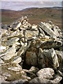
The cairn rises to the top of the gallery-stones (about 1.5 metres high) and is over 16 metres long by 14 metres wide. The court is obscured by cairn material and field-fences. The outstanding feature of the tomb is the steeply-pitched, packed corbelling of large slabs on the gallery, especially on the N side. The subsidiary chamber is almost concealed by corbelling and by stray débris from the cairn.
You may be viewing yesterday's version of this page. To see the most up to date information please register for a free account.
")
Do not use the above information on other web sites or publications without permission of the contributor.
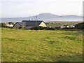
Nearby Images from Geograph Britain and Ireland:
©2006(licence)
©2009(licence)
©2011(licence)
©2011(licence)
©2009(licence)
The above images may not be of the site on this page, they are loaded from Geograph.
Please Submit an Image of this site or go out and take one for us!
Click here to see more info for this site
Nearby sites
Click here to view sites on an interactive map of the areaKey: Red: member's photo, Blue: 3rd party photo, Yellow: other image, Green: no photo - please go there and take one, Grey: site destroyed
Download sites to:
KML (Google Earth)
GPX (GPS waypoints)
CSV (Garmin/Navman)
CSV (Excel)
To unlock full downloads you need to sign up as a Contributory Member. Otherwise downloads are limited to 50 sites.
Turn off the page maps and other distractions
Nearby sites listing. In the following links * = Image available
921m WSW 236° Roonkeel Cairn Cairn
1.2km NNW 343° Cloonty Dun Stone Fort or Dun
1.3km WNW 288° Killadoon (1)* Standing Stone (Menhir)
1.5km SW 230° Roonkeel Tomb Burial Chamber or Dolmen
1.5km NW 305° Killadoon (2)* Standing Stone (Menhir)
2.3km WNW 297° Cross Lough Crannog Crannog
2.6km NW 317° Cloonlaur* Standing Stones (L744758)
3.0km WSW 239° Roonkeel Fort Promontory Fort / Cliff Castle
3.4km SSW 202° Corragaun II Stone Fort or Dun
3.4km ENE 78° Srahwee* Wedge Tomb (L7953074462)
3.8km S 188° Corragaun I Stone Fort or Dun
4.1km S 179° Cloonaghmanagh Ringfort Stone Fort or Dun
4.2km S 182° Claggan Ringfort Stone Fort or Dun
4.4km NE 56° Knockeen Stone* Standing Stone (Menhir) (L7986876200)
4.7km NE 43° Knockeen Tomb Burial Chamber or Dolmen
4.7km NNE 29° Formoyle Tomb Burial Chamber or Dolmen
4.8km S 173° Dadreen Cross Inscribed Pillar* Ancient Cross
5.3km E 96° Derryheeagh* Standing Stone (Menhir) (L8138073151)
9.8km W 280° Caher forts Promontory Fort / Cliff Castle
10.0km W 281° Teampaill Phádraig Early Christian Sculptured Stone
10.1km W 280° Caher stones Standing Stones
10.7km WNW 282° Tobar Muire Holy Well or Sacred Spring
11.1km ENE 65° Glenbaun Dun I Stone Fort or Dun
11.9km ENE 70° Glenbaun Dun II Stone Fort or Dun
14.1km SSW 208° Tully Lough* Crannog
View more nearby sites and additional images


 We would like to know more about this location. Please feel free to add a brief description and any relevant information in your own language.
 Wir möchten mehr über diese Stätte erfahren. Bitte zögern Sie nicht, eine kurze Beschreibung und relevante Informationen in Deutsch hinzuzufügen.
 Nous aimerions en savoir encore un peu sur les lieux. S'il vous plaît n'hesitez pas à ajouter une courte description et tous les renseignements pertinents dans votre propre langue.
 Quisieramos informarnos un poco más de las lugares. No dude en añadir una breve descripción y otros datos relevantes en su propio idioma.