

<< Our Photo Pages >> Serbiola Nuraghe - Broch or Nuraghe in Italy in Sardinia (Sardegna)
Submitted by SolarMegalith on Monday, 15 April 2024 Page Views: 19
Neolithic and Bronze AgeSite Name: Serbiola NuragheCountry: Italy Region: Sardinia (Sardegna) Type: Broch or Nuraghe
Nearest Town: Villaputzu
Latitude: 39.529688N Longitude: 9.627486E
Condition:
| 5 | Perfect |
| 4 | Almost Perfect |
| 3 | Reasonable but with some damage |
| 2 | Ruined but still recognisable as an ancient site |
| 1 | Pretty much destroyed, possibly visible as crop marks |
| 0 | No data. |
| -1 | Completely destroyed |
| 5 | Superb |
| 4 | Good |
| 3 | Ordinary |
| 2 | Not Good |
| 1 | Awful |
| 0 | No data. |
| 5 | Can be driven to, probably with disabled access |
| 4 | Short walk on a footpath |
| 3 | Requiring a bit more of a walk |
| 2 | A long walk |
| 1 | In the middle of nowhere, a nightmare to find |
| 0 | No data. |
| 5 | co-ordinates taken by GPS or official recorded co-ordinates |
| 4 | co-ordinates scaled from a detailed map |
| 3 | co-ordinates scaled from a bad map |
| 2 | co-ordinates of the nearest village |
| 1 | co-ordinates of the nearest town |
| 0 | no data |
Internal Links:
External Links:
I have visited· I would like to visit
SolarMegalith saw from a distance on 22nd Apr 2023 - their rating: Cond: 2
")
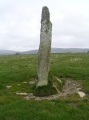
Nuraghe Serbiola is located within the military area north of Villaputzu and thus inaccessible, but it can be seen from the local road. The tower has 10.60 x 10.30m in diameter, and survive up to 4.50m of height. The entrance is located in the SE part of the nuraghe.
Reference:
Ledda R. (1989). Censimento archeologico nel territorio del commune di Villaputzu. Cagliari: Edizioni Castello (p. 233-234).
You may be viewing yesterday's version of this page. To see the most up to date information please register for a free account.
")
Do not use the above information on other web sites or publications without permission of the contributor.
Nearby Images from Flickr
![Castello di Quirra (Villaputzu) [on Explore March 6, 2022]](https://farm66.static.flickr.com/65535/51919907330_ca8a8ec92c_t.jpg)


The above images may not be of the site on this page, but were taken nearby. They are loaded from Flickr so please click on them for image credits.
Click here to see more info for this site
Nearby sites
Click here to view sites on an interactive map of the areaKey: Red: member's photo, Blue: 3rd party photo, Yellow: other image, Green: no photo - please go there and take one, Grey: site destroyed
Download sites to:
KML (Google Earth)
GPX (GPS waypoints)
CSV (Garmin/Navman)
CSV (Excel)
To unlock full downloads you need to sign up as a Contributory Member. Otherwise downloads are limited to 50 sites.
Turn off the page maps and other distractions
Nearby sites listing. In the following links * = Image available
2.6km NNE 14° Monte Arrubiu Nuraghe* Broch or Nuraghe
4.2km WNW 294° Guardia Manna Protonuraghe Broch or Nuraghe
8.3km S 184° Costa Funtanas Nuraghe Broch or Nuraghe
9.3km SSW 198° Baccu Biancu Nuraghe* Broch or Nuraghe
9.8km SW 232° Arcu S'Arena Nuraghe Broch or Nuraghe
12.6km NNW 331° Piddeddu Nuraghe Broch or Nuraghe
13.2km SW 214° Pranu Narbonis* Rock Cut Tomb
13.9km S 189° Murtas Nuraghe (Muravera)* Broch or Nuraghe
16.8km SSW 193° S'Acqua Seccis Nuraghe* Broch or Nuraghe
17.1km NNW 344° Marraghi Protonuraghe Broch or Nuraghe
18.3km NNW 341° Bau 'e Carrus Domus de Janas Rock Cut Tomb
18.4km N 0° Marosini Nuraghe Broch or Nuraghe
18.5km NNW 342° Grutas Nuraghe Broch or Nuraghe
18.7km SSW 213° Orridroxiu Nuraghe* Broch or Nuraghe
18.9km N 7° Aleri Nuraghe* Broch or Nuraghe
19.0km SW 217° Perdu Lodde Nuraghe* Broch or Nuraghe
19.2km NNW 344° S'Omu S'Orcu Nuraghe* Broch or Nuraghe
19.4km SW 214° Accu 'e Nius Tomba di Giganti* Chambered Tomb
19.7km SSW 205° Asoru Complesso Nuragico* Broch or Nuraghe
19.8km NNW 344° Sant'Elia Nuraghe* Broch or Nuraghe
21.0km SSW 213° Serra Is Abis Nuraghe* Broch or Nuraghe
21.3km W 275° Siliqua Nuraghe Broch or Nuraghe
21.4km SSW 210° Fottiano Nuraghe* Broch or Nuraghe
21.4km SSW 202° Monte Idda Nuraghe Broch or Nuraghe
21.7km SW 217° Miali Pili Nuraghe* Broch or Nuraghe
View more nearby sites and additional images


 We would like to know more about this location. Please feel free to add a brief description and any relevant information in your own language.
 Wir möchten mehr über diese Stätte erfahren. Bitte zögern Sie nicht, eine kurze Beschreibung und relevante Informationen in Deutsch hinzuzufügen.
 Nous aimerions en savoir encore un peu sur les lieux. S'il vous plaît n'hesitez pas à ajouter une courte description et tous les renseignements pertinents dans votre propre langue.
 Quisieramos informarnos un poco más de las lugares. No dude en añadir una breve descripción y otros datos relevantes en su propio idioma.