


<< Our Photo Pages >> Dasile - Rock Art in Italy in Lombardia
Submitted by CoppellaiaMatta on Wednesday, 03 April 2024 Page Views: 55
Multi-periodSite Name: DasileCountry: Italy Region: Lombardia Type: Rock Art
Nearest Town: Como Nearest Village: Chiavenna
Latitude: 46.338196N Longitude: 9.437437E
Condition:
| 5 | Perfect |
| 4 | Almost Perfect |
| 3 | Reasonable but with some damage |
| 2 | Ruined but still recognisable as an ancient site |
| 1 | Pretty much destroyed, possibly visible as crop marks |
| 0 | No data. |
| -1 | Completely destroyed |
| 5 | Superb |
| 4 | Good |
| 3 | Ordinary |
| 2 | Not Good |
| 1 | Awful |
| 0 | No data. |
| 5 | Can be driven to, probably with disabled access |
| 4 | Short walk on a footpath |
| 3 | Requiring a bit more of a walk |
| 2 | A long walk |
| 1 | In the middle of nowhere, a nightmare to find |
| 0 | No data. |
| 5 | co-ordinates taken by GPS or official recorded co-ordinates |
| 4 | co-ordinates scaled from a detailed map |
| 3 | co-ordinates scaled from a bad map |
| 2 | co-ordinates of the nearest village |
| 1 | co-ordinates of the nearest town |
| 0 | no data |
Internal Links:
External Links:
")
On an autumn outing to Dasile, a tiny hamlet above Chiavenna (Sondrio Province), my eagle-eyed sister noticed in the grass a small stone carved with some cup mark (three very deep and three rather shallow).
The stone is west facing and close around it, almost in a circle, there are bigger rocks protruding from the ground, some with perfectly flat sides, but on them we noticed no marking at all!
Walking through the hamlet itself, we came across two other carved stones. One presents minimal markings; the other, with several linked cup marks, is used as a bench.
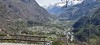
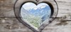
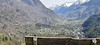
Dasile, and nearby more famous Savogno, with their breathtaking view over Bregaglia Valley, can be reached by car from Chiavenna (parking at 3 km from the hamlets), but taking the forest track is a much recommended option, the path winds up the side of the mountain, step after step, passing ruins and a beautiful ancient fountain.
You may be viewing yesterday's version of this page. To see the most up to date information please register for a free account.
")
")
")
")
Do not use the above information on other web sites or publications without permission of the contributor.
Nearby Images from Flickr


The above images may not be of the site on this page, but were taken nearby. They are loaded from Flickr so please click on them for image credits.
Click here to see more info for this site
Nearby sites
Click here to view sites on an interactive map of the areaKey: Red: member's photo, Blue: 3rd party photo, Yellow: other image, Green: no photo - please go there and take one, Grey: site destroyed
Download sites to:
KML (Google Earth)
GPX (GPS waypoints)
CSV (Garmin/Navman)
CSV (Excel)
To unlock full downloads you need to sign up as a Contributory Member. Otherwise downloads are limited to 50 sites.
Turn off the page maps and other distractions
Nearby sites listing. In the following links * = Image available
2.4km SW 231° Parco Marmitte dei Giganti* Ancient Mine, Quarry or other Industry
6.5km SE 145° Cairns at St Moritz* Cairn
7.3km ENE 78° Sasc di Pè (Foot soles slab)* Rock Art
11.4km E 88° Masso-Avello Stampa* NOT SET
12.4km NNW 327° Sass del Pariuliin* Rock Art
13.3km NNW 332° I sassi del Camanin* Rock Art
13.9km NNW 338° Sass del Sugherin del Mater* Rock Art
14.0km NNW 341° Val Sterla* Rock Art
14.6km NNW 333° Sasso altare* Rock Art
15.8km NNW 342° La Corte* Rock Art
16.9km WNW 292° Mesocco-Andergia Lepontische Stele Sculptured Stone
21.3km ENE 71° Maloja Stone with ornaments* Rock Art
21.3km ENE 71° Maloja Mortar Stone* Rock Art
22.6km WSW 250° Capèla dèla Riva Rock Art
22.9km WSW 246° Sass Pagan (Pagan stone)* Rock Art
22.9km WSW 251° Sass de l'Orch Wackelstein Rock Art
23.0km WSW 251° Verdabbio Schalensteingebiet* Rock Art
24.0km SE 140° Pozzo di Piazzalunga* Holy Well or Sacred Spring
24.1km SE 135° San Giuseppe* Rock Art
26.1km WSW 246° Carasole San Rocco* Rock Art
28.4km N 358° Anselmo Gadola Collection* Museum
31.6km NNE 26° Tinizong Senslas Rock Art
33.4km WSW 255° Claro sito preistorico Standing Stone (Menhir)
36.4km ENE 60° Druidenstein St. Moritz* Natural Stone / Erratic / Other Natural Feature
39.7km N 3° Carschenna* Rock Art
View more nearby sites and additional images


 We would like to know more about this location. Please feel free to add a brief description and any relevant information in your own language.
 Wir möchten mehr über diese Stätte erfahren. Bitte zögern Sie nicht, eine kurze Beschreibung und relevante Informationen in Deutsch hinzuzufügen.
 Nous aimerions en savoir encore un peu sur les lieux. S'il vous plaît n'hesitez pas à ajouter une courte description et tous les renseignements pertinents dans votre propre langue.
 Quisieramos informarnos un poco más de las lugares. No dude en añadir una breve descripción y otros datos relevantes en su propio idioma.