<< Other Photo Pages >> Leland Mounds - Artificial Mound in United States in The South
Submitted by stonetracker on Friday, 08 December 2023 Page Views: 146
Multi-periodSite Name: Leland Mounds Alternative Name: 22WS501Country: United States Region: The South Type: Artificial Mound
Nearest Town: Leland MS
Latitude: 33.418900N Longitude: 90.89097W
Condition:
| 5 | Perfect |
| 4 | Almost Perfect |
| 3 | Reasonable but with some damage |
| 2 | Ruined but still recognisable as an ancient site |
| 1 | Pretty much destroyed, possibly visible as crop marks |
| 0 | No data. |
| -1 | Completely destroyed |
| 5 | Superb |
| 4 | Good |
| 3 | Ordinary |
| 2 | Not Good |
| 1 | Awful |
| 0 | No data. |
| 5 | Can be driven to, probably with disabled access |
| 4 | Short walk on a footpath |
| 3 | Requiring a bit more of a walk |
| 2 | A long walk |
| 1 | In the middle of nowhere, a nightmare to find |
| 0 | No data. |
| 5 | co-ordinates taken by GPS or official recorded co-ordinates |
| 4 | co-ordinates scaled from a detailed map |
| 3 | co-ordinates scaled from a bad map |
| 2 | co-ordinates of the nearest village |
| 1 | co-ordinates of the nearest town |
| 0 | no data |
Internal Links:
External Links:
I have visited· I would like to visit
stonetracker would like to visit

Leland is one of a number of smaller Mississippian ceremonial mound sites that were likely constructed after the large Winterville site. It is not on the Mississippi Mound Trail but is designated as an "Indian Mound" on USGS topo maps.
As with many of these more modest late Mississippian sites in the Yazoo basin, this site is located close to Deer Creek. It is in the Lake George Phase of the Mississippian period which dates it between 1350-1500 CE.
Descriptions of this site appear in the Bureau of American Ethnology’s (BAE) Mound report and in Archaeology of Mississippi (Brown 1926:81-82).
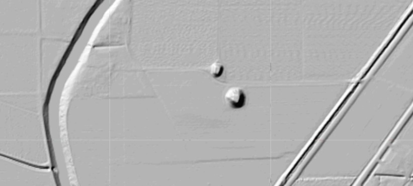
The Leland site originally included five mounds (although the illustration in the BAE Mound report indicates up to seven [Thomas 1894: Figure 161]) arranged around a roughly square plaza about 75 m on a side. Today two rectangular platform mounds remain. Mound A, the larger of the two, is on the east side of the plaza with a westward facing ramp. Mound B is perhaps 50 m northwest of Mound A. Brown (1926:79-80), based on the BAE Mound report, gives the following dimensions: Mound A is 30 ft high, and 200 by 175 ft at the base, Mound B is 15 ft high.
The area surrounding the mounds is cultivated and there is a cemetery atop one of the mounds. The site is on private property.
Location coordinates are for Mound A.
Source:
- H. Edwin Jackson 2013: Phase I Planning Document, Mississippi Mounds Trail, Middle Segment. Report submitted to the Mississippi Department of Archives and History, Jackson. Department of Anthropology and Sociology, University of Southern Mississippi, Hattiesburg.
You may be viewing yesterday's version of this page. To see the most up to date information please register for a free account.


Do not use the above information on other web sites or publications without permission of the contributor.
Nearby Images from Flickr


The above images may not be of the site on this page, but were taken nearby. They are loaded from Flickr so please click on them for image credits.
Click here to see more info for this site
Nearby sites
Click here to view sites on an interactive map of the areaKey: Red: member's photo, Blue: 3rd party photo, Yellow: other image, Green: no photo - please go there and take one, Grey: site destroyed
Download sites to:
KML (Google Earth)
GPX (GPS waypoints)
CSV (Garmin/Navman)
CSV (Excel)
To unlock full downloads you need to sign up as a Contributory Member. Otherwise downloads are limited to 50 sites.
Turn off the page maps and other distractions
Nearby sites listing. In the following links * = Image available
1.6km WSW 253° Stoneville Mounds Artificial Mound
11.5km WNW 299° Metcalfe Mounds Artificial Mound
17.6km WNW 295° Winterville* Artificial Mound
19.3km S 178° Arcola Mounds* Artificial Mound
20.4km NNE 18° Carter Mounds* Artificial Mound
36.6km S 175° Magee Mounds* Artificial Mound
36.9km SSW 196° Swan Lake Mounds* Artificial Mound
38.7km SSW 198° Law Mounds* Artificial Mound
39.8km NNW 348° Christmas Mound* Artificial Mound
42.7km ESE 118° Jaketown* Artificial Mound
48.3km S 189° Grace Mounds Artificial Mound
49.9km S 175° Anguilla Mound* Artificial Mound
52.8km S 178° Mont Helena* Artificial Mound
58.1km S 179° Rolling Fork Mounds* Artificial Mound
59.8km SW 218° Galloway Place Mound Artificial Mound
68.5km S 183° Cary Mounds* Artificial Mound
69.9km SSE 164° Lake George Mounds* Artificial Mound
75.5km NNW 335° Menard-Hodges Site* Artificial Mound
76.0km N 11° Alligator Mounds (Clarksdale)* Artificial Mound
86.4km SSW 200° Transylvania Mound* Artificial Mound
86.7km SSW 201° Julice Mound Artificial Mound
87.0km S 177° Aden Mounds* Artificial Mound
92.1km SSW 211° Mott Archaeological Preserve Artificial Mound
96.6km NNE 23° Dunn Mounds* Artificial Mound
99.1km SW 236° Caney Bayou Mound Artificial Mound
View more nearby sites and additional images


 We would like to know more about this location. Please feel free to add a brief description and any relevant information in your own language.
 Wir möchten mehr über diese Stätte erfahren. Bitte zögern Sie nicht, eine kurze Beschreibung und relevante Informationen in Deutsch hinzuzufügen.
 Nous aimerions en savoir encore un peu sur les lieux. S'il vous plaît n'hesitez pas à ajouter une courte description et tous les renseignements pertinents dans votre propre langue.
 Quisieramos informarnos un poco más de las lugares. No dude en añadir una breve descripción y otros datos relevantes en su propio idioma.