

<< Our Photo Pages >> Nedre Vist - Standing Stone (Menhir) in Norway in Nord-Trøndelag
Submitted by kenntha88 on Thursday, 27 October 2022 Page Views: 550
Iron Age and Later PrehistorySite Name: Nedre VistCountry: Norway Fylke: Nord-Trøndelag Type: Standing Stone (Menhir)
Nearest Town: Steinkjer Nearest Village: Straumen
Latitude: 63.928413N Longitude: 11.221142E
Condition:
| 5 | Perfect |
| 4 | Almost Perfect |
| 3 | Reasonable but with some damage |
| 2 | Ruined but still recognisable as an ancient site |
| 1 | Pretty much destroyed, possibly visible as crop marks |
| 0 | No data. |
| -1 | Completely destroyed |
| 5 | Superb |
| 4 | Good |
| 3 | Ordinary |
| 2 | Not Good |
| 1 | Awful |
| 0 | No data. |
| 5 | Can be driven to, probably with disabled access |
| 4 | Short walk on a footpath |
| 3 | Requiring a bit more of a walk |
| 2 | A long walk |
| 1 | In the middle of nowhere, a nightmare to find |
| 0 | No data. |
| 5 | co-ordinates taken by GPS or official recorded co-ordinates |
| 4 | co-ordinates scaled from a detailed map |
| 3 | co-ordinates scaled from a bad map |
| 2 | co-ordinates of the nearest village |
| 1 | co-ordinates of the nearest town |
| 0 | no data |
Internal Links:
External Links:
")
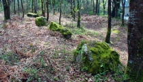
The standing stone is at the edge of a hill sloping down to the sea in the north. The surrounding hill has several rocky outcrops and high grass. Just north of the stone the terrain slopes steeply. A local road is going east to west just south of the stone and the stone is easily visible from the road.
The stone is 2,5 metres in height, 60cm wide and 30-40cm thick. It has an irregular appearance and the top ends in a sharp point.The stone had previsouly fallen over but was restored.
You may be viewing yesterday's version of this page. To see the most up to date information please register for a free account.
")
")
")
")
Do not use the above information on other web sites or publications without permission of the contributor.
Nearby Images from Flickr

The above images may not be of the site on this page, but were taken nearby. They are loaded from Flickr so please click on them for image credits.
Click here to see more info for this site
Nearby sites
Click here to view sites on an interactive map of the areaKey: Red: member's photo, Blue: 3rd party photo, Yellow: other image, Green: no photo - please go there and take one, Grey: site destroyed
Download sites to:
KML (Google Earth)
GPX (GPS waypoints)
CSV (Garmin/Navman)
CSV (Excel)
To unlock full downloads you need to sign up as a Contributory Member. Otherwise downloads are limited to 50 sites.
Turn off the page maps and other distractions
Nearby sites listing. In the following links * = Image available
4.4km NE 35° Storberget* Hillfort
4.5km ESE 114° Hommeldalen Standing Stones* Standing Stones
5.2km NNE 32° Søndre Grønnesby Boat House* Ancient Village or Settlement
5.3km NNE 30° Frammigar`n* Cairn
5.4km SE 127° Verdal Cemetery* Barrow Cemetery
5.5km NNE 31° Grønnesby Søndre* Cairn
5.6km WSW 239° Gjålåvikja* Barrow Cemetery
6.4km SE 124° Bossnes* Standing Stone (Menhir)
6.8km S 178° Hjulstad* Standing Stone (Menhir)
7.1km SSE 155° Vangsåkern* Standing Stone (Menhir)
8.4km ENE 74° Kvitvang barrow cemetery* Barrow Cemetery
9.0km SSE 149° Roel Hynne* Round Barrow(s)
9.3km ENE 60° Limbuhaugen* Cist
9.7km SSE 148° Haugum* Barrow Cemetery
9.7km NE 56° Toldnes cairns* Barrow Cemetery
10.0km SSE 155° Vikamarka-Grøtneset* Cist
10.1km SE 128° Nedre Lorås standing stone* Standing Stone (Menhir)
10.1km ENE 68° Vist burial mound* Round Barrow(s)
10.3km SSE 155° Sørvika-Grøtneset* Cairn
10.4km E 81° Lian barrow* Round Barrow(s)
10.4km SE 144° Kuru Barrows* Round Barrow(s)
10.5km E 81° Lianhøgda* Cairn
10.9km E 83° Jøremsvegen Phallic Stone* Sculptured Stone
11.0km SE 143° Kverkilhaugen* Hillfort
11.1km ENE 75° Ålberg* Barrow Cemetery
View more nearby sites and additional images


 We would like to know more about this location. Please feel free to add a brief description and any relevant information in your own language.
 Wir möchten mehr über diese Stätte erfahren. Bitte zögern Sie nicht, eine kurze Beschreibung und relevante Informationen in Deutsch hinzuzufügen.
 Nous aimerions en savoir encore un peu sur les lieux. S'il vous plaît n'hesitez pas à ajouter une courte description et tous les renseignements pertinents dans votre propre langue.
 Quisieramos informarnos un poco más de las lugares. No dude en añadir una breve descripción y otros datos relevantes en su propio idioma.