


<< Our Photo Pages >> Rønehaugen - Round Barrow(s) in Norway in Oppland
Submitted by kenntha88 on Friday, 11 September 2020 Page Views: 332
Neolithic and Bronze AgeSite Name: RønehaugenCountry: Norway Fylke: Oppland Type: Round Barrow(s)
Nearest Town: Fagernes Nearest Village: Røn
Latitude: 61.047837N Longitude: 9.048265E
Condition:
| 5 | Perfect |
| 4 | Almost Perfect |
| 3 | Reasonable but with some damage |
| 2 | Ruined but still recognisable as an ancient site |
| 1 | Pretty much destroyed, possibly visible as crop marks |
| 0 | No data. |
| -1 | Completely destroyed |
| 5 | Superb |
| 4 | Good |
| 3 | Ordinary |
| 2 | Not Good |
| 1 | Awful |
| 0 | No data. |
| 5 | Can be driven to, probably with disabled access |
| 4 | Short walk on a footpath |
| 3 | Requiring a bit more of a walk |
| 2 | A long walk |
| 1 | In the middle of nowhere, a nightmare to find |
| 0 | No data. |
| 5 | co-ordinates taken by GPS or official recorded co-ordinates |
| 4 | co-ordinates scaled from a detailed map |
| 3 | co-ordinates scaled from a bad map |
| 2 | co-ordinates of the nearest village |
| 1 | co-ordinates of the nearest town |
| 0 | no data |
Internal Links:
External Links:
")
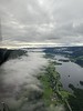
At the farm Røn is a large round barrow. It is however overgrown with tight forest and large trees and the details of the barrow is impossible to make out. There are also some old tracktors and farming machinery parked almost at the site blocking some of the view.
According to the Kulturminnesøk the barrow is around 25 metres in diameter and around 3-4 metres in height. However the shape cannot be made out. I hope someday the area and barrow can be cleaned up better!
You may be viewing yesterday's version of this page. To see the most up to date information please register for a free account.
Do not use the above information on other web sites or publications without permission of the contributor.
Nearby Images from Flickr


The above images may not be of the site on this page, but were taken nearby. They are loaded from Flickr so please click on them for image credits.
Click here to see more info for this site
Nearby sites
Click here to view sites on an interactive map of the areaKey: Red: member's photo, Blue: 3rd party photo, Yellow: other image, Green: no photo - please go there and take one, Grey: site destroyed
Download sites to:
KML (Google Earth)
GPX (GPS waypoints)
CSV (Garmin/Navman)
CSV (Excel)
To unlock full downloads you need to sign up as a Contributory Member. Otherwise downloads are limited to 50 sites.
Turn off the page maps and other distractions
Nearby sites listing. In the following links * = Image available
4.6km NNW 335° Einangssteinen* Standing Stone (Menhir)
5.3km NNW 335° Garberg* Barrow Cemetery
5.7km NW 324° Timbervegen* Round Barrow(s)
7.6km NW 324° Lysthaugen Vestre Slidre* Round Barrow(s)
7.9km NW 325° Nordre-Hausåker* Round Barrow(s)
10.0km SE 138° Lille-Strand Barrow* Round Barrow(s)
13.4km NW 317° Kitilhaugen* Round Barrow(s)
26.9km WNW 289° Vang Runestone* Carving
27.7km WNW 293° Sparstad* Standing Stones
48.7km ESE 118° Møllerstufossen Helleristninger* Carving
56.5km ESE 104° Erstadenget* Cairn
60.6km ESE 111° Nybakktåje* Barrow Cemetery
61.9km W 273° Turkestovhaugen* Cairn
62.4km W 274° Spenning Cairn and Standing Stone* Standing Stone (Menhir)
68.7km W 270° Nedre Kvame Gravfelt* Barrow Cemetery
71.5km NNE 31° Vinstra Helleristninger* Rock Art
72.0km WNW 295° Ytre Moa* Ancient Village or Settlement
72.4km E 79° Fåberg Runestone* Carving
73.0km NNE 33° Grytberget* Rock Art
74.0km W 271° Bjørkum* Ancient Village or Settlement
74.2km NE 41° Hundorp* Ancient Village or Settlement
74.7km NE 40° Sør-Fron-Prestegård* Round Barrow(s)
74.7km ENE 78° Drotten Helleristning* Rock Art
75.1km NE 40° Tingflata* Stone Circle
75.4km SW 220° Fekjo Gravplass* Barrow Cemetery
View more nearby sites and additional images


 We would like to know more about this location. Please feel free to add a brief description and any relevant information in your own language.
 Wir möchten mehr über diese Stätte erfahren. Bitte zögern Sie nicht, eine kurze Beschreibung und relevante Informationen in Deutsch hinzuzufügen.
 Nous aimerions en savoir encore un peu sur les lieux. S'il vous plaît n'hesitez pas à ajouter une courte description et tous les renseignements pertinents dans votre propre langue.
 Quisieramos informarnos un poco más de las lugares. No dude en añadir una breve descripción y otros datos relevantes en su propio idioma.