

<< Our Photo Pages >> Žírovice prehistoric graveyard and settlement - Cairn in Czech Republic in Bohemia
Submitted by ladrin on Saturday, 26 November 2016 Page Views: 2223
Neolithic and Bronze AgeSite Name: Žírovice prehistoric graveyard and settlement Alternative Name: Horní Lomany archaeological siteCountry: Czech Republic Region: Bohemia Type: Cairn
Nearest Town: Františkovi Lázně Nearest Village: Žirovice
Latitude: 50.140876N Longitude: 12.346038E
Condition:
| 5 | Perfect |
| 4 | Almost Perfect |
| 3 | Reasonable but with some damage |
| 2 | Ruined but still recognisable as an ancient site |
| 1 | Pretty much destroyed, possibly visible as crop marks |
| 0 | No data. |
| -1 | Completely destroyed |
| 5 | Superb |
| 4 | Good |
| 3 | Ordinary |
| 2 | Not Good |
| 1 | Awful |
| 0 | No data. |
| 5 | Can be driven to, probably with disabled access |
| 4 | Short walk on a footpath |
| 3 | Requiring a bit more of a walk |
| 2 | A long walk |
| 1 | In the middle of nowhere, a nightmare to find |
| 0 | No data. |
| 5 | co-ordinates taken by GPS or official recorded co-ordinates |
| 4 | co-ordinates scaled from a detailed map |
| 3 | co-ordinates scaled from a bad map |
| 2 | co-ordinates of the nearest village |
| 1 | co-ordinates of the nearest town |
| 0 | no data |
Internal Links:
External Links:
")
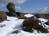
The remains of two large round cairns and 50 burial urns are hidden in the little forest above Mlýnský pond. First discovered allegedly in 1880 but serious research was carried out gradually from 1929 till 1958. Unfortunately all the site suffered much during sand mining at the beginning of the 20th century. Archaeological finds include a bronze ring fragment, jewellery, a bronze bracelet, part of a spiral, a bronze bolt and many fragments of pottery.
To the great surprise of the archaeologists, a settlement was found in the close vicinity of the necropolis, which is very unsual.
You may be viewing yesterday's version of this page. To see the most up to date information please register for a free account.
")
")
")
")
")
")
")
")
Do not use the above information on other web sites or publications without permission of the contributor.
Click here to see more info for this site
Nearby sites
Click here to view sites on an interactive map of the areaKey: Red: member's photo, Blue: 3rd party photo, Yellow: other image, Green: no photo - please go there and take one, Grey: site destroyed
Download sites to:
KML (Google Earth)
GPX (GPS waypoints)
CSV (Garmin/Navman)
CSV (Excel)
To unlock full downloads you need to sign up as a Contributory Member. Otherwise downloads are limited to 50 sites.
Turn off the page maps and other distractions
Nearby sites listing. In the following links * = Image available
4.4km E 100° Dvorek propitiatory cross* Ancient Cross
4.6km S 190° Komorní Hůrka stone cross* Ancient Cross
4.8km WSW 258° Poustka Wells* Holy Well or Sacred Spring
5.0km WNW 285° Hazlov Stone Crosses* Ancient Cross
5.9km E 97° Povodí propitiatory cross* Ancient Cross
6.9km W 280° Polná Propitiatory Cross 1* Ancient Cross
7.1km ENE 75° Milhostov 2 propitiatory crosses* Ancient Cross
7.3km WNW 295° Lipná propitiatory cross* Ancient Cross
7.7km ENE 65° Cross Stone Mostek* Standing Stone (Menhir)
7.8km ENE 77° Milhostov 1 propitiatory crosses* Ancient Cross
7.9km W 280° Polná Propitiatory Cross 2* Ancient Cross
8.9km N 358° Plesná stone crosses* Ancient Cross
9.2km NE 54° Ringval Mlýnek* Misc. Earthwork
9.6km NNE 15° Lomnička Stone Cross* Ancient Cross
9.9km SSE 160° Podhrad stone crosses* Ancient Cross
10.5km S 179° Stone Cross Háje* Ancient Cross
10.6km ENE 79° Ringval Hluboká* Misc. Earthwork
11.9km NNE 30° Ringval Božetín* Misc. Earthwork
13.2km E 85° Stone Cross Chlum II* Ancient Cross
14.0km E 87° Svatá Studánka Chlum* Holy Well or Sacred Spring
14.4km E 83° Stone Cross Chlum* Ancient Cross
15.4km ENE 58° Krajkova Stone Cross* Ancient Cross
15.5km E 87° Dasnice propitiatory cross* Ancient Cross
17.0km ESE 117° Ringval Těšov I* Misc. Earthwork
17.4km W 269° Herrgottstein (Hendelhammer)* Rock Art
View more nearby sites and additional images


 We would like to know more about this location. Please feel free to add a brief description and any relevant information in your own language.
 Wir möchten mehr über diese Stätte erfahren. Bitte zögern Sie nicht, eine kurze Beschreibung und relevante Informationen in Deutsch hinzuzufügen.
 Nous aimerions en savoir encore un peu sur les lieux. S'il vous plaît n'hesitez pas à ajouter une courte description et tous les renseignements pertinents dans votre propre langue.
 Quisieramos informarnos un poco más de las lugares. No dude en añadir una breve descripción y otros datos relevantes en su propio idioma.