


<< Our Photo Pages >> Menhir de la Fage A02 - Standing Stone (Menhir) in France in Languedoc:Lozère (48)
Submitted by holger_rix on Tuesday, 19 April 2016 Page Views: 857
Neolithic and Bronze AgeSite Name: Menhir de la Fage A02Country: France Département: Languedoc:Lozère (48) Type: Standing Stone (Menhir)
Nearest Town: Florac Nearest Village: Les Bondons
Latitude: 44.410310N Longitude: 3.577320E
Condition:
| 5 | Perfect |
| 4 | Almost Perfect |
| 3 | Reasonable but with some damage |
| 2 | Ruined but still recognisable as an ancient site |
| 1 | Pretty much destroyed, possibly visible as crop marks |
| 0 | No data. |
| -1 | Completely destroyed |
| 5 | Superb |
| 4 | Good |
| 3 | Ordinary |
| 2 | Not Good |
| 1 | Awful |
| 0 | No data. |
| 5 | Can be driven to, probably with disabled access |
| 4 | Short walk on a footpath |
| 3 | Requiring a bit more of a walk |
| 2 | A long walk |
| 1 | In the middle of nowhere, a nightmare to find |
| 0 | No data. |
| 5 | co-ordinates taken by GPS or official recorded co-ordinates |
| 4 | co-ordinates scaled from a detailed map |
| 3 | co-ordinates scaled from a bad map |
| 2 | co-ordinates of the nearest village |
| 1 | co-ordinates of the nearest town |
| 0 | no data |
Be the first person to rate this site - see the 'Contribute!' box in the right hand menu.
Internal Links:
External Links:
I have visited· I would like to visit
bishop_pam visited on 26th Aug 2018 - their rating: Cond: 4 Amb: 3 Access: 2
")
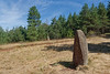
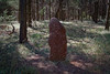
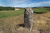
These menhirs are of medium size, located along a path in a forest.
Information with Pictures:
dolmen1.free.fr
(Numbering not official)
You may be viewing yesterday's version of this page. To see the most up to date information please register for a free account.
Do not use the above information on other web sites or publications without permission of the contributor.
Nearby Images from Flickr
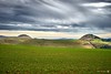
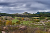
The above images may not be of the site on this page, but were taken nearby. They are loaded from Flickr so please click on them for image credits.
Click here to see more info for this site
Nearby sites
Click here to view sites on an interactive map of the areaKey: Red: member's photo, Blue: 3rd party photo, Yellow: other image, Green: no photo - please go there and take one, Grey: site destroyed
Download sites to:
KML (Google Earth)
GPX (GPS waypoints)
CSV (Garmin/Navman)
CSV (Excel)
To unlock full downloads you need to sign up as a Contributory Member. Otherwise downloads are limited to 50 sites.
Turn off the page maps and other distractions
Nearby sites listing. In the following links * = Image available
45m W 259° Menhir de la Fage A01* Standing Stone (Menhir)
347m NE 43° Menhir de la Fage A03* Standing Stone (Menhir)
653m ESE 109° Trois Pierres de Chabusse* Stone Row / Alignment
762m NE 36° Menhir de la Fage A04* Standing Stone (Menhir)
764m ESE 103° Combettes menhirs 2* Standing Stone (Menhir)
852m NE 36° Menhir de la Fage A05* Standing Stone (Menhir)
882m SSE 163° Combettes menhirs* Standing Stones
935m NE 38° Menhir de la Fage A06* Standing Stone (Menhir)
964m NE 38° Menhir de la Fage A07* Standing Stone (Menhir)
984m E 82° Combettes menhirs 1* Standing Stone (Menhir)
986m E 86° La Fage Dolmen* Burial Chamber or Dolmen
1.1km WSW 239° Nozières menhirs Standing Stones
1.2km NE 36° Menhir de la Fage A08* Standing Stone (Menhir)
1.2km NE 35° Menhirs de la Fage A* Standing Stones
1.3km ENE 68° Menhir de la Fage B01* Standing Stone (Menhir)
1.3km NE 35° Menhir de la Borie 1* Standing Stone (Menhir)
1.3km ENE 69° Menhir de la Fage B02* Standing Stone (Menhir)
1.4km ENE 67° Pierre des Trois Communes* Standing Stone (Menhir)
1.4km ENE 65° Menhir de la Fage B11* Standing Stone (Menhir)
1.4km ENE 70° Menhir de la Fage B03* Standing Stone (Menhir)
1.4km ENE 77° Menhir de la Fage B09* Standing Stone (Menhir)
1.5km ENE 69° Menhirs de la Fage B* Standing Stones
1.5km ENE 74° Menhir de la Fage B05* Standing Stone (Menhir)
1.5km ENE 70° Menhir de la Fage B04* Standing Stone (Menhir)
1.6km ENE 76° Menhir de la Fage B06* Standing Stone (Menhir)
View more nearby sites and additional images


 We would like to know more about this location. Please feel free to add a brief description and any relevant information in your own language.
 Wir möchten mehr über diese Stätte erfahren. Bitte zögern Sie nicht, eine kurze Beschreibung und relevante Informationen in Deutsch hinzuzufügen.
 Nous aimerions en savoir encore un peu sur les lieux. S'il vous plaît n'hesitez pas à ajouter une courte description et tous les renseignements pertinents dans votre propre langue.
 Quisieramos informarnos un poco más de las lugares. No dude en añadir una breve descripción y otros datos relevantes en su propio idioma.