


<< Our Photo Pages >> Coed y Bwynydd Camp - Hillfort in Wales in Monmouthshire
Submitted by Andy B on Thursday, 03 February 2011 Page Views: 18146
Iron Age and Later PrehistorySite Name: Coed y Bwynydd CampCountry: Wales County: Monmouthshire Type: Hillfort
Nearest Town: Abergavenny Nearest Village: Raglan
Map Ref: SO36500680 Landranger Map Number: 161
Latitude: 51.756272N Longitude: 2.92137W
Condition:
| 5 | Perfect |
| 4 | Almost Perfect |
| 3 | Reasonable but with some damage |
| 2 | Ruined but still recognisable as an ancient site |
| 1 | Pretty much destroyed, possibly visible as crop marks |
| 0 | No data. |
| -1 | Completely destroyed |
| 5 | Superb |
| 4 | Good |
| 3 | Ordinary |
| 2 | Not Good |
| 1 | Awful |
| 0 | No data. |
| 5 | Can be driven to, probably with disabled access |
| 4 | Short walk on a footpath |
| 3 | Requiring a bit more of a walk |
| 2 | A long walk |
| 1 | In the middle of nowhere, a nightmare to find |
| 0 | No data. |
| 5 | co-ordinates taken by GPS or official recorded co-ordinates |
| 4 | co-ordinates scaled from a detailed map |
| 3 | co-ordinates scaled from a bad map |
| 2 | co-ordinates of the nearest village |
| 1 | co-ordinates of the nearest town |
| 0 | no data |
Internal Links:
External Links:
I have visited· I would like to visit
PAB SolarMegalith would like to visit
coin visited - their rating: Cond: 3 Amb: 5 Access: 5
")
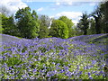
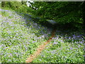
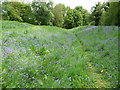
It is a popular destination for walkers, especially in bluebell time. A plaque at the entrance states that the site was “Presented to the National Trust by Captain Geoffrey Crawshay in memory of Sgt R.A.Owens, Royal Air Force, of Llanfair Kilgeddin, killed on active service on August 7th 1943 aged 21.”
Note: Castle, snowdrops and ancient hill fort walk, 5th February, also to a nearby hillfort on the 20th
You may be viewing yesterday's version of this page. To see the most up to date information please register for a free account.
")
Do not use the above information on other web sites or publications without permission of the contributor.
Nearby Images from Geograph Britain and Ireland:
©2005(licence)
©2010(licence)
©2014(licence)
©2012(licence)
©2010(licence)
The above images may not be of the site on this page, they are loaded from Geograph.
Please Submit an Image of this site or go out and take one for us!
Click here to see more info for this site
Nearby sites
Key: Red: member's photo, Blue: 3rd party photo, Yellow: other image, Green: no photo - please go there and take one, Grey: site destroyed
Download sites to:
KML (Google Earth)
GPX (GPS waypoints)
CSV (Garmin/Navman)
CSV (Excel)
To unlock full downloads you need to sign up as a Contributory Member. Otherwise downloads are limited to 50 sites.
Turn off the page maps and other distractions
Nearby sites listing. In the following links * = Image available
1.8km NW 310° Llanover Fawr Round Barrow(s) (SO351080)
2.5km SSW 192° Trostrey Stone Circle (SO35950435)
2.8km ENE 66° Camp Hill Bryngwyn Ancient Village or Settlement (SO391079)
3.3km SSE 155° Llancayo Camp* Hillfort (SO37830383)
4.2km SSW 192° Llancayo Barrow Cemetery* Barrow Cemetery (SO356027)
4.9km E 79° Raglan Cross* Ancient Cross (SO4134007660)
5.4km SE 143° Gwehelog Fawr Ancient Village or Settlement (SO397025)
5.5km WNW 289° Ffynnon Gofer (Llanover)* Holy Well or Sacred Spring (SO313087)
6.9km S 171° Twyn Bell Camp Ancient Village or Settlement (SO375000)
6.9km WSW 255° Ffynnon Angaeron* Holy Well or Sacred Spring (SO298051)
7.5km ESE 117° Great House Camp* Hillfort (SO432033)
8.2km SE 133° Earthwork Misc. Earthwork (SO424011)
8.7km W 271° Carn-y-Garnclochdy Ring Cairn (SO27780708)
8.9km WNW 283° Carn-y-Big Fach Cist (SO27790885)
9.4km SE 138° Camp Farm* Misc. Earthwork (ST427997)
9.4km NW 318° Priory Well (Abergavenny)* Holy Well or Sacred Spring (SO30231387)
9.5km W 274° Capel Newydd* Carving (SO27020763)
9.6km SW 233° Pontypool Gorsedd Circle Modern Stone Circle etc (SO2875001181)
9.7km NW 317° Abergavenny Museum* Museum (SO2995913943)
9.9km WSW 257° Garnteg Menhir* Standing Stone (Menhir) (SO268047)
9.9km WNW 288° Carn y Defaid (N)* Cairn (SO27081004)
10.0km WNW 288° Carn y Defaid (S)* Cairn (SO27040997)
10.0km WSW 257° Garnteg Barrows* Barrow Cemetery (SO267047)
10.2km S 174° St Cybi's Well (Llangybi)* Holy Well or Sacred Spring (ST3744796662)
10.2km WNW 283° Mynydd Garn Fawr* Ancient Trackway (SO2655609300)
View more nearby sites and additional images


 We would like to know more about this location. Please feel free to add a brief description and any relevant information in your own language.
 Wir möchten mehr über diese Stätte erfahren. Bitte zögern Sie nicht, eine kurze Beschreibung und relevante Informationen in Deutsch hinzuzufügen.
 Nous aimerions en savoir encore un peu sur les lieux. S'il vous plaît n'hesitez pas à ajouter une courte description et tous les renseignements pertinents dans votre propre langue.
 Quisieramos informarnos un poco más de las lugares. No dude en añadir una breve descripción y otros datos relevantes en su propio idioma.