

<< Our Photo Pages >> Jūōmae Yokoana - Rock Cut Tomb in Japan in Honshū
Submitted by Aska on Saturday, 07 November 2015 Page Views: 1351
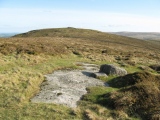
Rock ArtSite Name: Jūōmae Yokoana Alternative Name: Juomae Yokoana 十王前横穴, Kanburi Ana かんぶり穴Country: Japan Region: Honshū Type: Rock Cut Tomb
Nearest Town: Hitachi (Ibaraki pref.) Nearest Village: Jūōchō-Ishi 十
Latitude: 36.663960N Longitude: 140.701550E
Condition:
| 5 | Perfect |
| 4 | Almost Perfect |
| 3 | Reasonable but with some damage |
| 2 | Ruined but still recognisable as an ancient site |
| 1 | Pretty much destroyed, possibly visible as crop marks |
| 0 | No data. |
| -1 | Completely destroyed |
| 5 | Superb |
| 4 | Good |
| 3 | Ordinary |
| 2 | Not Good |
| 1 | Awful |
| 0 | No data. |
| 5 | Can be driven to, probably with disabled access |
| 4 | Short walk on a footpath |
| 3 | Requiring a bit more of a walk |
| 2 | A long walk |
| 1 | In the middle of nowhere, a nightmare to find |
| 0 | No data. |
| 5 | co-ordinates taken by GPS or official recorded co-ordinates |
| 4 | co-ordinates scaled from a detailed map |
| 3 | co-ordinates scaled from a bad map |
| 2 | co-ordinates of the nearest village |
| 1 | co-ordinates of the nearest town |
| 0 | no data |
Internal Links:
External Links:
")
On the cliff behind the Hitachi Electric Wire factory, 29 rock cut tombs lie. Tombs nos.2, 11 and 14 have mural paintings. Some of them is triangle pattern, like Ōzuka Kofun in far Kyūshū and rather nearby Nakata Yokoana. But it is difficult to distinguish the tomb number.
You may be viewing yesterday's version of this page. To see the most up to date information please register for a free account.
Do not use the above information on other web sites or publications without permission of the contributor.
Nearby sites
Click here to view sites on an interactive map of the areaDownload sites to:
KML (Google Earth)
GPX (GPS waypoints)
CSV (Garmin/Navman)
CSV (Excel)
To unlock full downloads you need to sign up as a Contributory Member. Otherwise downloads are limited to 50 sites.
Nearby sites listing. In the following links * = Image available
20.0km SW 225° Hata Bakke Yokoana* Rock Cut Tomb
23.9km WSW 239° Nekobuchi Yokoana* Rock Cut Tomb
25.0km WSW 243° Mi Kofun* Passage Grave
28.4km SW 225° Shirakōchi Kofungun* Passage Grave
31.7km SSW 203° Mawatari Haniwa Seisaku Iseki* Ancient Mine, Quarry or other Industry
34.4km SSW 200° Torazuka Kofun* Long Barrow
37.7km SW 231° Masui Kofun* Passage Grave
39.5km SSW 211° Yoshida Kofun* Passage Grave
43.0km SW 225° Kurefushi-no-Sato Kofun Kōen park* Passage Grave
44.7km NNE 32° Nakata Yokoana* Rock Cut Tomb
50.5km SSW 211° Obata Kitayama Haniwa Serisaku Iseki* Ancient Mine, Quarry or other Industry
52.2km SW 231° Shumpū Banri-sō* Modern Stone Circle etc
62.4km WSW 238° Hanazono Kofungun* Passage Grave
64.2km NW 325° Nojikubo Kofun* Passage Grave
64.2km NNW 328° Izumizaki Yokoana* Rock Cut Tomb
68.9km SSW 207° Ajiki Taishi Kofon* Passage Grave
73.6km W 264° Nagaoka Hyakuana* Rock Cut Tomb
75.6km W 269° KamiYokokura* Standing Stones
77.5km S 184° Kaname-ishi* Misc. Earthwork
83.1km WSW 239° Funadama Kofun* Passage Grave
91.7km NNE 17° History and Folklore Museum Futaba-Machi* Museum
99.2km W 276° Taiyū-in shrine* Modern Stone Circle etc
101.5km SSW 202° Ryūkakuji Kofungun* Passage Grave
110.6km SSW 193° Shibayama Kohun Haniwa Museum* Museum
120.0km WSW 255° Itakura Jinja shrine* Standing Stone (Menhir)


 We would like to know more about this location. Please feel free to add a brief description and any relevant information in your own language.
 Wir möchten mehr über diese Stätte erfahren. Bitte zögern Sie nicht, eine kurze Beschreibung und relevante Informationen in Deutsch hinzuzufügen.
 Nous aimerions en savoir encore un peu sur les lieux. S'il vous plaît n'hesitez pas à ajouter une courte description et tous les renseignements pertinents dans votre propre langue.
 Quisieramos informarnos un poco más de las lugares. No dude en añadir una breve descripción y otros datos relevantes en su propio idioma.